Introduction
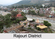 Rajouri District is a district of Jammu region in Indian state of Jammu and Kashmir which had been part of Poonch district prior to 1967. It is famous for its "kalari" (kind of cheese) and has six tehsils. The District has an area of 2630 square kilometres with peculiar physical features. Maize, wheat and rice are the main crops of the area and the main source of the irrigation is the river Tawi that originates from the mountains of Pir Panjal.
History of Rajouri District
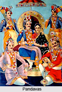 Rajouri district was a region of immense significance in ancient times. In the Mahabharata there was a kingdom known as Panchal Desa. The king of this State was Panchal Naresh whose daughter Draupadi was married to the Pandavas. The Historians identify Panchalya Desha as the area in Panchal range of mountains. Rajouri was also a part of this kingdom of Panchal Naresh. The region was then known as Rajapuri - `the land of Kings`. It finds its mention in the travel account of Chinese traveller Hiuen Tsang who visited the town in 632 A.D. and described it as a part of Kashmiri territory. Still earlier in the Buddhist period, Rajouri formed a part of Gandhar territory (Afghanistan, Gandhar and Tashkent) and later was incorporated in the province called Darabhisanga which comprised the hilly stretch from Poonch to Kashmir. Those days Laharkote in Poonch district and Rajouri had emerged as two influential states of the area.
Ancient History of Rajouri District
According to some historians, second branch of Aryan emigrants crossed Himalayas in the north and west and settled in Rajouri and Poonch area. Rajouri, Bhimber and Naushera were integrated within the territory of Abhisar, which was one of the hill states of the Punjab Kingdom. Early records of incomplete nature show that in the 4th century B.C., there existed in the north west of India a federal type of political set up in which Abhisar with its capital Rajouri was also incorporated. At the time of Alexander`s invasion, Rajouri was at the summit of its splendour. In the Mauryan period, the town of Rajouri was a great trade centre.
Medieval History of Rajouri District
During the Mughal rule, the rulers of Rajouri have embraced Islam though they retained the title of Raja. Albaurni visited Rajouri with Sultan Masud (Son of Sultan Mahmud) in 1036 A.D. In his book "India" he wrote name of Rajouri as Raja Vari. Srivar, the writer of `Raj Tirangini` written during the administration of Sultan Zain-Ul-Abdin, also named this area as Raja Vari. It is believed that Raja Vari is the changed shape of Rajapuri. Mirza Zafarulla Khan, the writer of `Tarikh Rajgan-E-Rajour` illustrated in his book that this place was in the beginning known as Raj-Avar and then altered from Rajour to Rajouri. But the old people in the villages still label the place as Rajour. With the course of time the name changed from Raja`s Raj Avar to Raja Puri, Rajpuri to Raj Vari, Raj Vari to Raj Vara, Raj Vara to Raj Avar, Raj Avar to Rajour and then Rajour to Rajouri. As per Rajtirangini of Kalhan, Rajouri emerged as principality in about 1003 A.D. The first ruler of this kingdom was Raja Prithvi Paul. From 1033 A.D. to 1194 A.D. Raja Prithvi Paul defeated Pir Panchal Pass at the time of incursion of Sultan Mehmud in1021 A.D. Raja Sangram Paul safeguarded his Principality Rajouri when Raja Harash of Kashmir assaulted his country in 1089 A.D. Sangram Paul fought so courageously that Raja Harash was obliged to return from Prithvi Paul fort without capturing Rajouri. Jaral Muslim Rajas rebuilt Rajouri city at the time of their rule. Number of Fort, Sarai, Mosque and Baradaries were constructed with the help of Mughals, on Mughal road.
Modern History of Rajouri District
The area of Rajouri principality included proper Rajouri, Thanna, Bagla Azim Garh, Behrote, Chingus, Darhal, Nagrota and Phalyana etc. After taking the charge of Rajouri from Raja Faqir Ullah in 1846, Maharaja Gulab Singh changed the name of Rajouri to Rampur. He appointed Mian Hathu as Governor of Rajouri. Mian Hathu remained in Rajouri up to 1846 A.D. He constructed a stunning temple in between Thanna Nallah in close proximity to Rajouri city. He also built Rajouri Fort at Dhannidhar village. After Mian Hathu, Rajouri was transformed into a Tehsil and affiliated with Bhimber District. In 1904 A.D., this Tehsil was bifurcated from Bhimber and affiliated with Reasi District. After Independence, Rajouri became part of the newly constituted Poonch-Rajouri District. On 1st January 1968, Rajouri emerged as a new District on the map of the State of Jammu and Kashmir.
Geography of Rajouri District
 The District has an area of 2630 square kilometres with peculiar physical features. District Rajouri is 154 kilometres away from Winter Capital Jammu. It is located in the foothills of Pir Panjal Range. The Districts Udhampur and Jammu surround the District in the East, Line of actual control passes on the Southern side, on the West it is bounded by Poonch District and Pulwama District is on the North. The climate of the region varies from semitropical in the Southern part comprising Nowshera, Sunderbani and Kalakote to temperate in the mountainous Northern part comprising the area of Rajouri, Thannamandi and Koteranka Tehsils of the District. The average rainfall recorded here is 500 mm and average temperature varies from 7.42 degree Celsius to 37.4 degree Celsius.
Demography of Rajouri District
According to the 2011 census, Rajouri district has a population of 642,415. The district has a population density of 235 inhabitants per square kilometre. Rajouri has a sex ratio of 863 females for every 1000 males and a literacy rate of 68.54 percent. The religious distribution, in accord with the 2011 census, was 402,879 Muslim (62.7154percent), 221,880 Hindu (34.5454percent), 2.4154percent Sikhs and others.
Urdu and English are the main mediums of instruction and the main native languages are Pahari and Gujari. Pahari is mainly spoken by the Malik community that forms majority of Darhal Malkan. Gujari is primarily spoken by the Gujjar and Bakarwal which add much Muslim population of Rajouri.
Urdu and English are the main mediums of instruction and the main native languages are Pahari and Gujari. Pahari is mainly spoken by the Malik community that forms majority of Darhal Malkan. Gujari is primarily spoken by the Gujjar and Bakarwal which add much Muslim population of Rajouri.
Administration of Rajouri District
The district is divided into seven Tehsils and seven blocks. Rajouri District comprises of 379 villages (375 are inhabited villages) out of which Hindu population dominates 157 villages while Muslim dominates 228 villages and Sikh population dominates 2 villages. This district consists of nine blocks: Rajouri, Doonji, Nowshera, Darhal, Manjakote, Thanamandi, Sunderbani, Kalakote, and Budhal. Each block consists of a number of panchayats.
Education of Rajouri District
 Rajouri District has a literacy rate of 57.65 percent. There are 719 primary schools and 18 higher secondary and 82 secondary schools in the district. There are three colleges in this district of Jammu and Kashmir. The government has done a lot for Gujjars and Bakerwals in the matter of education by way of permanent and mobile schools, starting of Gujjar and Bakerwals hostels at the District level with free boarding and lodging facilities up to 12th class and reservation in employment and vocational institutions.
Culture of Rajouri District
 Culture plays an important role in the lives of the people of Rajouri District. The people in the region have a distinctive cultural heritage and unique historical backdrop. The Pahari tribes of the place comprise Hindu, Muslim and Sikhs whose cultural affinity and language is binding force of their cultural heritage. Their mother tongue is a great connecting factor of pahari speaking people, which have been nourishing their age-old secular, lookout also. The life of the people of Rajouri is a blend of Poonchi, Pahari, Dogri, Gujri and Kashmiri culture.
Art and Crafts of Rajouri District
Art and crafts defines the culture of the district to a great extent. Embroidery, basket making, Blanket making, Namda, Chikri wood carving, Tilla (Copper) work, and Gabba making, etc. are the main handicrafts of the region. With the ushering of modern age, some of these handicrafts due to high cost of production as compared to the machine made articles have lost buyers and as a result of which the persons who were involved in production of these articles have abandoned manufacturing such items and have resorted to other activities of earning their source of revenue. The main items under embroidery craft consist of Shah Embroidery (both Sojni and Aari). Embroidery on bed sheets, Pillows, TV or Radio curtains, wall Hangings, covers, sofa set covers, table covers, napkins, etc.
 Folk Songs and Dances of Rajouri District
Rajouri district is a land of matchless and unimaginable beauty in the form of wonderful folk songs and folk dances. The most important languages spoken in the region are Pahari, Poonchi, Gujri, Dogri and Kashmiri. The life of the people of Rajouri is a merge of Poonchi, Pahari, Dogri, Gujri and Kashmiri culture. Folk songs and folk dances of a particular region portray the living style of people, their tastes, costumes, traditions, rituals and culture. Different cultural forms and styles of singing and dances are still prevalent in the region. Gujjars are one of the most important segments of the population of the district. Folk song Dhindi, Kenchi, Cucko, Mehndi, Baisakh, Dholan, Laari, and Bar-Shams are renowned amongst the people. Baisakh is the folk song of summer when the people migrate to Dhoks with their livestock.
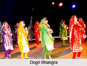
Dances express the deepest joy and contentment of a man. These are the real pictures of the life of the people and their folk culture. Dances are always associated with some fairs, festivals or worship of God or Goddess. District Rajouri touches the border of Poonch, Jammu and Udhampur, So that the main dances of Rajouri are Dogri Bhangra, Gogri Dance, Keekli, Letri Naach, Jattar, Jagarana,Chowki Naach, and Rouf etc.
Fairs and Festivals of Rajouri District
Fairs and festivals have a unique appeal of their own. These occasions give a meeting place for people from different shades of opinion. In Rajouri district, these had been a matchless heritage of celebrating fairs and festivals and the people have adopted these as a part of life. Dusshera is celebrated all over the district. In the Rajouri town Ramlila is held at Town Hall, Rajouri. Nowshera Day is another occasion of majestic and esteemed importance. The town folk and army personal recall the courage of the civilians of Nowshera in repulsing the attack of Pakistani invaders on December 16, 1975, on the day jointly. Every Year, on this day a commemoration function is held, attended by thousands of people including large numbers of civilians, ex-soldiers and army personnel. Holi, the festival of colours gives a unique charisma and is celebrated in an unparalleled style. The week long festival carries rich traditions of all Hindus, Sikhs and Muslims and this unity in diversity had been a matchless heritage of people of Rajouri district since the ancient period.
The favourite dishes of Paharies are rice, meat, and bread of maize. Pahari women wear silver ornaments like Jhumka, Long, Chhalla, Kangan, Hasieri (necklace), Payal etc. While the men wear silver and golden rings. These ornaments are of typical type, which are distinctive from the ornaments of the other tribes residing in the same belt. Kabaddi is the main indigenous game of Paharies, which is played in the whole pahari belt. The lifting of Bughdar (stone lifting) is another game of Paharies, which shows the power of young man. Thus the culture of Rajouri district is indeed unique and colourful.
Art and Crafts of Rajouri District
 Art and crafts of Rajouri District is an integral part of the culture of the place. The region is rich in forest wealth and the climate is cold during winter months. The high reaches of Pir Panjal, dividing Kashmir and Rajouri valley, experience reasonable to heavy snow fall during winter months as a result of which during the winter months, when it is not feasible for the local people to earn their livelihood outside their residences, they prefer to dedicate their time to handicraft activities, so as to add-on their meager incomes. Due to the diversity of handicrafts, it is often called the mini Kashmir or the Kashmir of Jammu region. Since the old Mughal road to Kashmir valley passes through the length of this district, the handicraft activities got a face off with the patronage of Mughal Emperors.
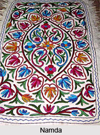
Embroidery, Blanket making, Namda and Gabba making, Chikri-wood carving, Tilla (Copper) work, basket making, etc. were the most important handicrafts of the former days. With the ushering of modern age, some of these handicrafts due to high cost of production as compared to the machine made articles have lost buyers as result of which the persons who were concerned in production of these articles have deserted manufacturing such items and have resorted to other activities of earning their source of revenue. But Embroidery, Blanket making, Namda, Gabba making, and Chikri wood crafts somehow still survive heavy odds.
Several handicraft centers have been opened by the Jammu and Kashmir Government to educate local male and females of the district in diverse crafts like Embroidery, Namda, Gabba making and Ckikri wood carving. The Handicraft centres are imparting training in remote areas of this district. The skilled persons are encouraged by the Government to form cooperative Societies, which facilitate them to earn their livelihood. The State Government, to some extent, also provides market cover to them. Embroidery on bed sheets, Pillows, table covers, curtains, TV or Radio covers, sofa set covers, wall Hangings, napkins, etc. are well known in the district.
Namda Gabba Making is facing extinction since the local manufactures are poor and not in a situation to buy the raw material in adequate quantity so as to keep themselves busy during the winter months in particular and whole year in general. This fine craft of namda, gabba making requires Governments initiative for survival by providing raw materials and market facility through out the year, if possible at par with their Kashmiri counterparts. Blanket making is the old craft and it still continues on the same old line, without the introduction of the up to date technology. Chikri Wood Carving in the real terms is a live craft with a few complaints. The artisans occupied in this craft are for the most part located at Shahdara Sharief, Thannamandi and Budhal. These areas produce a lot of articles for household use as well as ornamental purpose. It could also help if the government provides exposure to all the leading Chikri Wood Craftsmen and help them in getting new designs of their carvings, which could have better national and international demands.
Folk Art of Rajouri District
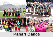 Folk art of Rajouri District comprises folk dances and songs which defines the culture of the district of Jammu and Kashmir. Rajouri is a land of matchless and inconceivable beauty in the form of exotic landscape, verdant meadows, sparkling and shimmering snow white streams, towering snow clad mountains, rich fauna and flora, ancient mountains, rich heritage, vivid cultural life and wonderful folk songs and folk dances. Folk songs and folk dances of a particular region depict the living style of people, their tastes, traditions, costumes, rituals and culture. Different cultural forms and styles of singing and dances are still prevalent in the region. Folk forms have remained the favourites of the masses.
Folk Songs of Rajouri District
Folk songs such as Dhindi, Kenchi, Cuckoo, Sopahiya, Mehndi, Baisakh, Dholan, Chann, Laari, and Bar-Shams are renowned amongst the people. Gujjars are one of the most important segments of the population of the district. The main ballads of the region are Noora and Taago. Noora was a Gujjar Chief of Gursai who was ditched by his own servant and brutally killed by his opponents. His life history is explained in the folk song Noora. Likewise ballad Taajo is a well-known number in which bravery of Taajo has been woven beautifully. Dhindi was a beautiful charming girl who falls in love with the hero of the tale Nathiya Deedarh. This song is in romantic from and talks about her immortal love. Baisakh is the folk song of summer when the people migrate to Dhoks with their livestock. The beauty of the nature, flora and fauna of the area, lush green meadows oozing and gushing springs are beautifully described in the song.
Cuckoo is a symbolic song in which the bird Cuckoo is used as a symbol. This song is very famous amongst the women folk as it is a song of separation and remembrance. Sopahiya is a song in the praise of a lover who has gone to fight war. Chann and Dholan are pahari romantic songs and are full of praise of beloved, who is compared with, Chann, (Moon). Dholan word is also used for lover. Every line of the song ends with the word, Dholan. Natt is devotional song sung in Ziarat for praise of Prophet Hazarat Mohammad. Kashmiri folk song Chakri and Rouf is also sung in the region due to Kashmiri population.
Folk Dances of Rajouri District
Dances express the innermost joy and happiness of a man. These are the real pictures of the life of the people and their folk culture. Dances are always connected with some fairs, festivals or worship of God or Goddess. District Rajouri touches the border of Poonch, Jammu and Udhampur, So that the main dances of Rajouri are Dogri Bhangra, Gogri Dance, Letri Naach, Chowki Naach, Jattar, Jagarana, Keekli and Roff etc. These dances are performed on the fairs and festivals; every action depicts the harvesting process.
Gujjri Naach is a form of dance which is very famous with the Gujjar community. Performance of the dance is arranged on the marriage ceremony of a boy. This folk dance is very simple but charming. Male dances in their traditional costumes form a line with sticks in their hands and on the other side female dances change formations on the rhythm of Dhol. Letri dance is performed while cutting the grass hence known as labour dance. Chowki Naach is similar to that of Dogri folk dance, Fummaniyan. People from all communities perform this dance jointly, which shows a nice picture of communal harmony and natural integration. This dance is purely a religious dance in the honour of the Gram-Devta or Kul-Devta. The Bindloo and the Jagarna are the dances set to the theme of marriage and martial relationships.
Keekli is a simple but entertaining dance. No instrument is used. The girls perform this dance. The main instruments played with these folk songs and folk dances are algoza, Dokra, Sarnai, Glass, Thumbak Nari, Sargi, bansuri or flute, Dholak and Dhol etc. Rouf dance is performed by women on the occasion of Id. Popular songs are Chhakri and Hafiz Naghma. The most popular instrument of Kashmiri action song is Tumbak Nari.
Tourism in Rajouri District
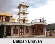
 Tourism in Rajouri District of Jammu and Kashmir is an amusement for the visitors. Rajouri district has quite a good number of charming spots. There is a wide scope for pilgrimage, leisure, and nature and adventure tourism in this district. Places worth seeing near Rajouri district are Rajouri fort, Gurudwara Chhati Badshahi, Balidan Bhavan, Rama Temple Jama Masjid and Shiv Mandir among others.
Pilgrimage Tourism in Rajouri District
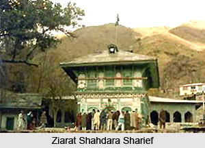
 Pilgrimage Tourism in Rajouri District in the state of Jammu and Kashmir is quite popular all across the globe. Ziarat Shahdara Sharief is about 30 Kms in the north of Rajauri and is bounded by stunning high mountain peeks, deep belt of forests, green pastures, springs and strings. Thousands of people from every religion visit the shrine every year and offer prayers. Ten thousand people can offer prayer in Jamia Masjid Shahdara Shrief. The Urs of Hazrat Ghulam Shah Baadshah is celebrated on 10th of Muharram every year. Apart from a number of Gurdwaras existing in the District, Gurdwara Chhati Badshahi Rajouri is a very significant religious place which has been constructed in the memory of 6th Guru Hargobind Sahib Ji (1595-1646 AD) who stayed at this place in 1616 AD when he was on the way to Kashmir along with Emperor Jahangir. Gurdwara Chatti Badshahi has great importance for Hindus and number of Hindu devotees each day visits the Gurdwara for offering their prayer. The main congregation is organised on Sunday and the Birthday of Guru Hargobind Ji Maharaj is celebrated with great interest jointly by Sikhs and Hindus every year.
 Mangla Mata Dev Asthan is situated near village Bhawani in Nowshera Tehsil of District Rajouri in a forest area. People come here from far and across for darshan. The asthan is located in an attractive forest area. The picturesque beauty of the area is such that this place can be developed as religious tourism by constructing Sarais, viewing desks, Dak Bungalows etc. By this way, the financial system of the area can also be developed apart from the encouragement of the visitors. Temple at Peer Badesar is situated in the restricted area. All the four sides of the temple and both the sides of the passage to the temple are enclosed with many bells which on shaking produce a harmonious resonance. It is said that this temple belongs to the Lord Shiva and Goddess Sati. This temple was got constructed by Kanishka in the memory of Veer Vadweshavar, the son of Lord Shiva. Another similarly important place of pilgrimage is the shrine of Sain Ganji Sahib Qadri situated about 10 kms, from Rajouri town over-looking Darhal nallah, which too attracts thousands of pilgrims throughout the year in particular on the eve of the annual Urs which generally takes place in the first week of October every year. The Shrine is regarded as a symbol of purity and tolerance and it is because of the sacredness of the place that a large number of people belonging to diverse religions visit there to seek the blessings of the Saint.
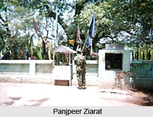
The Dera Baba Beeram Shah Ji Dutt is located on a mound. The followers of Baba Beeram Shah Ji visit the Dera every day. The most important function is organised every year on the following Sunday of Baisakhi. Hindus and Sikhs from all over Poonch and Rajouri areas are visiting the Dera and participate in the mela. Panj Peer Shrine is visited by a huge number of people including Army and Para Military personnel visit the place round the year particularly on Thursdays for seeking blessings and paying obeisance. The Ziarat of Qutab Shah Wali at Dani Dhar near Rajouri is also very popular. People of diverse religions visit the place round the year to seek blessings of the Saint whole family ancestry is believed to be the same as that of Roshan Shah Wali Sahib, whose shrine exists at Jammu. In the same way, at Banpuri temple in Sunderbani, a grand Yagya takes place on every Baisakhi which draws large number of people from Rajouri, Poonch and Jammu districts who come and participate in the religious rites. The Ziarat of Sain Walidad situated at village Bhathian in Thannamandi against the environment of the towering Pir Kalewa Mountain is also a well-known place of worship and attracts a number of pilgrims. The Ziarat at Rattan Pir also commands great reverence by people of different communities. In short, there is hardly any region in the district where there is no shrine of community or the other.
Temples in Rajouri
 Since it borders Pakistan, it is the haven of infiltration and militant activities .With intense problems of militant insurgency, Rajouri is home to affected Muslims and Hindus who try to live in unison, with religious diversification noted in the presence of temples and Islamic architecture. Quite ideally therefore a wide number of temples and mosques entwine Rajouri.
Banpuri Temple, Sunderbani, Rajouri, Jammu & Kashmir: Banpuri Temple receives a new look in Baisakhi every year, with the faithful crowding the arena to demonstrate their admiration.
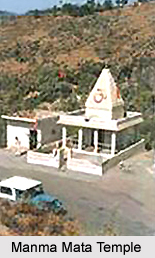
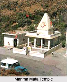
Manma Mata Temple, Kalakote, Rajouri, Jammu & Kashmir: Filled with mythical tales, Manma Mata Temple has earned a pride place in the hearts of the devotees, due to the Devi`s supposed spiritual prowess.
Peer Badesar Temple, Rajouri, Jammu & Kashmir: Built by a stalwart and dedicated to another stalwart, Peer Badesar Temple provides a magnificent view of the villages on the other side of the border.
Gurudwara Dera Baba Beeram Shahji Dutt, Rajouri, Jammu & Kashmir: Gurudwara Dera Baba Beeram Shahji Dutt is consecrated to Baba Beeram Shah, with people from other religions joining in to pay their respect.
Gurudwara Chatti Patshahi Bangla Sahib, Rajouri, Jammu & Kashmir: Gurudwara Chatti Patshahi Bangla Sahib conducts numerous charitable works, and has connections with not only Sikh Guru, but also emperor Jahangir.
Nature Tourism of Rajouri District
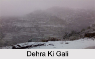
Nature Tourism of Rajouri District is indeed a delight for the travellers. Dehra Ki Gali is a beautiful picturesque spot is situated at a height of plus 6600 feet above sea level, in the Pir Panjal Range and is one of the passes connecting Rajouri and Poonch districts. It experiences profound snowfall during winter months. Thick vegetation cover attracts and charms the visitor. Kotranka at the distance of 40 kms is a gorgeous tourist spot located on the right bank of river Ans. During summer this spot affords a great attraction to the nature lovers and tourists. This is a picturesque charming and peaceful spot to retire to in the summer heat. This is the coldest place of the district Rajouri, which remains under the blanket of snow for more than four-five months. Klhad is another striking place near Budhal. It is a small and attractive plateau and the waters there remains cold in summer and hot in winter. The Pir Panjal falling under the authority of Rajouri district is a storehouse of beautiful lakes situated at an altitude between 13000 ft. to 14500 ft.
Pir Panjal area is full of lakes and meadows and a place to be well enjoyed by the tourists. Bhag Sar is the biggest lake. Most of the big lakes are located at the boundary line between Jammu division and the Kashmir valley and drain into the Kashmir valley. The important lakes are Sukh Sar, Bhag Sar, Diya Sar, Chandan Sar, Katori Sar, Akal Dakshni, Nandan Sar, Raviwalli marg group of lakes, Chamar Sar, Padyaran Sar I and II, Katori Sar in Bela Marg and Smat Sar. A visit to these lakes gives ever lasting life long memories. Nature lovers shall certainly find their heaven in these lakes.
 Leisure Tourism in Rajouri District
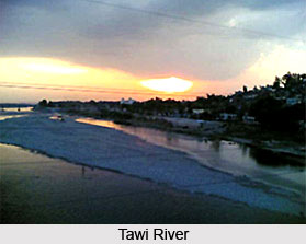 Leisure Tourism offers a lot to the tourists of Rajouri District of Jammu and Kashmir State. Rajouri lies on the majestic Mughal road leading to Kashmir. Here a small number of architectural fragments of early medieval temple of Kashmir style can be seen in Andarkot mohalla, which are the only remnants of ancient Hindu rule. Muradpur on Rajouri chingas road has the medieval sarai overlooking the green fields with lower portion of its enclosure wall having a bastion at the corners. About one kilometer from this building and on the bank of the Tawi River there are relics of a mosque and projected cell of assembly hall. The mosque is of magnificent dimension with courtyard in front raised on elevated level.
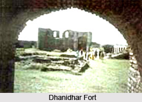
The Mughal vestiges spread on either banks of the Tawi River comprise forts cum palaces, sarais, mosques and gardens etc. The ruins of a small mosque in the market are still in existence. The garden located on the slope of a plateau is most appealing of all the Mughal remnants in Rajouri. It consists of a walled enclosure separated into four parts by two channels with a fountain at the centre. A double storied baradari stands in the middle of west wall overlooking the river. The garden wall has bastions at the corners. The main entrance to the garden is on the south side but there also exist, two entrances in the west wall and one in the north wall. On an elevated hill northeast of the town, there is a fort, which commands a panoramic view of the valley. It is locally known as Danidhar. Dhanidhar Fort was completed in 1855 AD. The key purpose for the construction of the Fort was to keep Dogra Forces in this safer place because from this place, the whole Valley of Rajouri could be inspected. This Fort has been used by the defense in the past.
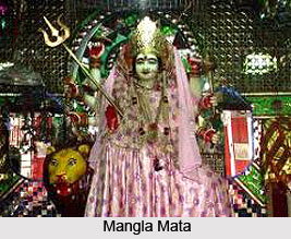
 Mangaladevi Fort lies here on east side of the region and is one of the biggest forts in Rajouri district. It is an invincible fort difficult of admission because of tremendous sublimity and well-built fortification. On three sides it is incredibly bordered by a river and on the remaining side it had a grueling uphill ascent. It is built on an asymmetrical plan with bastions at some distance. The fortification wall, survived in the most of the places is about 6 mtrs high and is strengthened by two rows of machicolations. The main gateway connected with a flight of steep steps. Inside area of the fort is uneven and is full of vegetation. It contains a treasury building a large tank in damaged condition besides a modern temple of Mangla Mata. Tourists take a great delight in visiting such historical wonders.
Chingas is a small village situated on the right bank of Tawi River on Jammu- Rajouri highway. Mughal sarai of the village is historically prominent for containing mortal remnants of Emperor Jahangir who died on his way to Kashmir. It is a well designed building with two apartments namely the residential complex and the open yard. Both the apartments have separate gateways and are also connected to each other on the inside. The residential complex is built within walled enclosure and contains arched cell with opening towards the courtyard. Its gateway in the western wall comprises a central chamber with domed roof and a small guard`s room on either flank. In construction of the building random rubbles, large pebbles and lakhauri bricks are used in lime surkhi mortar. Thannamandi was a most important halting place before entering Kashmir Valley through Rattan Shah Pir Pass. Here Mughal rulers constructed a magnificent sarai, which is distinguished for its ornamental carvings.
Nowshera is a large town in Rajouri District. Sarai of the town is more airy and diverse from others in its general design. It comprises two enclosures one within the other. The outermost enclosures have double storied bastions at the corners and are crowned by crenellated fortification. It contains a row of alcoves on the inside and has machicolations. An impressive gateway in the middle of western wall provides an admission to the sarai. It is the only gateway in Kashmir which contains square stone pillar surmounted by bracket, a feature perpetually found in the Mughal buildings of Agra and Fatehpur Sikri. Nadpur Sarai about 10 Kms. from Nowshera was used as minor halting station during Mughal period. It consists of an open rectangular patio surrounded by a walled enclosure with battlement-patterned adornment at the top. It is provided with two rows of machicolations and is entered through magnificent gateways on the east and west sides. The frontage of the gateway has alcoves at the base and is ornamented with recessed panels.
Adventure Tourism in Rajouri District
Rajouri district is a gifted place for adventure tourists. Trekking satisfies one of man`s basic impulses, the urge to travel forth and seek adventure. Rajouri town is located at the foothills of Pir Panjal Range. The snow-clad Pir Panjal Range has its own magnetism. In fact it stands out more outstanding than the Himalayas as it is nearer to the plains and its imposing slopes are awe-inspiring. The crest of Pir Panjal is covered with snow and there are numerous climbed and virgin peaks between 15290 ft. to 16000 ft. like Dhakyar-15290 ft., Brahma-15400 ft., Kotoria-15000 ft., Budhal Pir-15170 feet, Tatakuti-15557 ft. Sun set-15510 ft., Kagha Alana and Handoo Peak near Chamcchi Sar Lake calling for the mountaineer`s interest. There exist more than twelve passes on the Pir Panjal Range between the Rajouri-Poonch Valleys and the Kashmir Valley. These are Galli Medhan pass, Chor Galli, Choti Galli, Jamina pass, Noor Pur Galli, Pir Galli, Budhal Pir Pass Handoo Pass, Ruperi Pass, and Pir Panjal near Konsarnag lake (between 11500 ft. to 15000 ft.) which one can cross from one side to the other.
Visiting Information of Rajouri District
Rajouri district is situated 154 kilometres away from Jammu, the winter capital of Jammu and Kashmir. The only means to reach Rajouri is through Road. Buses, Video Coaches and shared taxis are plying on the road on regular basis throughout the day from the Jammu Bus Stand.