Introduction
 Thane District is an administrative district of Maharashtra. It constitutes a part of North Konkan Region, which lies between the Sahyadri hills in the east and the Arabian Sea in the west. It has coastal line of about 113 kms. District head quarter Thane is about 25 kms from Chhatrapati Shivaji International Airport and 35 kms from Mumbai City. The total geographical area of Thane District is 9558 sq kms which is around 3.11 percent of the total area of the state. In Thane District, there are around 4518 Primary Schools, nearly 937 Secondary Schools, 189 Higher Education Institutes and around 72 Adult Education Adivasi Ashram Schools.
History of Thane District
History of Thane District can be divided into four major periods, the early Hindu period partly mythic and partly historic, coming down to about 1300 AD and properly called Ancient period; the Muslim period lasting from 1300 to 1660 AD, the Maratha period from 1660 to 1800 AD; and the British period since 1880. From pre-historic times the Thane coast has had relation with land beyond the Indian Ocean. Thane District forms part of North Konkan also called Aprant (The western end) later known as Puri-Konkan after its capital Puri. The earliest known fact in the history of Thane coast and incidentally of Apranta belongs to engraving of Ashoka edicts. The Shilharas ruled over North Konkan for move than 400 years. During the Mughal period, Turk rulers had destroyed many temples and Churches of the region. Under the strong rule of Muhammad Bin Tughlaq the Mughal`s maintained their supremacy in north Konkan. Portuguese history would be incomplete without the mention of Vasai. The Portuguese power passed into the hands of Maratha after a long siege by Chimaji Appa, brother of Peshwa Bajirao I. For about sixty-four years, from 1739 to 1802 Vasai remained under the Maratha finally, in 1802 by the Treaty of Vasai it became a British possession and in 1818 it was incorporated in the Bombay Presidency. Under the British rule the trade of the district had developed tremendously.
Geography of Thane District
Topography of Thane District includes several important physical divisions including Sahyadri hill ranges, forest areas, cultivated lands, and two major rivers. Ulhas River and Vaitarna River are the two main rivers of Thane District. 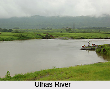 Mainly three types of soils are found in Thane District - regur soil, red soil and brownish black soil. Regur soil, which is found in Dahanu, Palghar, Vasai and Thane tehsils, is fertile and useful for horticulture, paddy cultivation and vegetables. Whereas, red soil which is found in Mokhada, Talasari and some parts of other tehsils on the eastern slopes is useful for growing coarse millets. The third type of soil found in Bhiwandi, Kalyan and Shahapur tehsils is useful, particularly for paddy cultivation. Climate of Thane District is basically tropical. However, the climate of coastal plains differs from the climate on the eastern slopes. July is the rainiest month. Minimum temperature recorded here is 17.5 degree Celsius and maximum recorded temperature is 34.4 degree Celsius. Average annual rainfall is 2,576 mm.
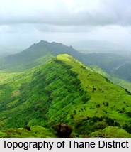 Geography of Thane District is divided into three physical divisions namely the central portion having Sahyadri ranges and its slopes is mainly forest area; the central region covering mostly paddy fields and the western part along the West coast, where horticulture, cultivation of high quality fodder and vegetables are practiced. The Sahyadri ranges having unbroken boundary run in the Eastern region of the district. There are also spurs running laterally to the main ranges. The heights of the mountains are high on the east and diminish gradually westwards. The mountain ranges also spread unevenly in the central region of the district.
The climate of Thane District is distinctly different on the coastal plains and on the eastern slopes. Being fully tropical, the climate on the coast, the coastal strip including Thane, Vasai, Palghar and Dahanu tehsils is very humid and warm. On the other hand, the climate on the eastern slopes and in the plains at the foot of the slopes is comparatively less humid. However, variation in temperature in the eastern region is more than that on the coastal strip. The maximum temperature varies between 28 degree Celsius and 35 degree Celsius and the minimum temperature ranges between 16 degree Celsius and 26 degree Celsius. Thane District gets assured rainfall of 2000 to 4000 mm from south-west monsoons during the months of June to September. Generally highest rainfall is recorded in the month of July. It is considerably more inland than on the coast. It is also less towards the north more inland than on the coast. It is also less towards the north than towards the south.
Geography of Thane District includes two main rivers, which join the sea on the west coast and these are Vaitarna River and Ulhas River. The Vaitarna River rises in the hills near Trimbak in the Nashik District and flowing southwards takes a westwards turn entering Thane district at Vihigaon in Shahapur tehsil. It is further passes across northern boundary of Shahapur tehsil to enter Wada tehsil near Nishet village and then taking East-West course through the middle of Wada tehsil. It enters Palghar tehsil and runs in north-west direction up to Manor, where-from it turns south-west and southwards up to village Navghar forming Vaitarna creek at the south of Palghar tehsil. The important tributaries of Vaitarna are Pinjal, Daherja, Surya and Tansa. The important tributaries of Ulhas River in Thane District are Bharvi, Bhatsa and Kalu rivers. The soils of Thane District can be divided into three categories, regur soil, red soil in the eastern region mostly on the slopes and brownish-black soil in the patches of the valleys mostly lying between the coastal plains and the hilly slopes of Sahyadri hills.
Demography of Thane District
Total population of Thane District as per 2001 Census is 81,31,849, of which rural population is 22,29,376 and urban population is 59,02,473. Male population in the district is 43,77,747 and female population is 37,54,102. Further, total literacy rate according to 2001 Census in Thane District is 80.67 percent, out of which male literacy rate is 87.06 percent and female literacy rate is 73.10 percent.
Yeoor Hills or Mama Bhanja Hills is a hill station in Thane district. This naturally beautiful and pollution free area attracts lot of people.
Administration of Thane District
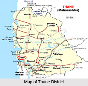
Thane District has 15 tehsils out of which Shahapur tehsil is the largest in area and Talasari tehsil is the smallest in area. Administration of Thane District includes Municipal Corporations, 9 Municipal Councils, 960 Gram Panchayats, and 61 police stations. Total Panchayat Samitis in Thane District is 13. There are altogether 37 cities and 1,748 villages in Thane District.


