Introduction
 Sirsa District is one of the 21 administrative districts of Haryana with its headquarters at Sirsa town. This district lies between 29 degree 14 minutes and 30 degree north latitudes and 74 degree 29 minutes and 75 degree 18 minutes east longitudes, forming the extreme west corner of Haryana. Sirsa District is bounded by Faridkot District and Bathinda District of Punjab in the north and north east, by Ganganagar District of Rajasthan in the west and south and Hisar District in the east. Thus, it touches the interstate boundaries on three sides and is connected with one district of its own state only in the eastern side. People here mostly speak Bagri language.
History of Sirsa District
According to the history of Sirsa District, the name of the district is derived from its headquarters Sirsa. It is said to be one of the oldest places of North India and its ancient name was `Sairishaka`, which finds mention in Mahabharata. In Mahabharata, Sairishaka is described as being taken by Nakula in his conquest of the western quarter. It must have been a flourishing city in the 5th century BC as it has been mentioned by Panini.
History of Sirsa District as an administrative unit states that Sirsa seems to be in the administrative division of Hisar Feroza during the reign of Firoz Shah Tughlaq. In the time of Akbar, Sirsa was one of the dasturs of Hisar Feroza Sarkar and much of its area lying in the present Sirsa District was covered by Mahals of Fatehabad, Bhattu, Bhangiwal (Darba), Sirsa, Bhatner (or Hanumangarh, Rajasthan) and Paniyana (Rajasthan). With the decline of Mughal Empire, the track comprising Sirsa District came under the control of Marathas. The entire territory of Delhi of which the tract formed a part was ceded by the Marathas to the British in 1810. Sirsa was part of the outlying district of Delhi territory under the charge of an assistant to the Resident. In 1819, Delhi territory was divided into three districts - Central which included Delhi, Southern including Rewari, and North-Western including Panipat, Hansi, Hisar, Sirsa and Rohtak. In 1820, the latter was again sub-divided into Northern and Western and Sirsa along with Hansi, Hisar and Bhiwani formed Western district (Haryana District later known as Hisar District).
In 1837, Sirsa and Rania Parganas were taken out of Haryana District and along with Guda and Malaut Parganas were formed into a separate district called Bhattiana. The Pargana of Darba from Hisar District and the small Pargana of Rori confiscated from erstwhile princely state of Nabha were transferred to Bhattiana in 1838 and 1847 respectively. In 1844, Wattu Pargana running up to Sutlej region was added in Bhattiana district. The whole of Delhi territory along with district of Bhattiana and Hisar was transferred to Punjab in 1858 and the district of Bhattiana was renamed as Sirsa. In 1861, 42 villages of Tibi tract of Rania Pargana were transferred to the then state of Bikaner.
Sirsa District which comprised three tehsils of Sirsa, Mandi Dabwali and Fazilka was abolished in 1884 and Sirsa tehsil (consisting of 199 villages) and 126 villages of Mandi Dabwali tehsil formed one tehsil and the same was merged in the Hisar District and the rest of the portion was transferred to the Ferozepur district (Punjab). There was no change till the independence of the country except that a village was transferred from Sirsa tehsil to the then state of Bikaner in 1906. The entire area of the district was included in the new state of Haryana on November 1st, 1966. In 1968, Sirsa tehsil was bifurcated into Sirsa and Mandi Dabwali tehsils. In 1974, three villages of Mandi Dabwali tehsil were transferred to Sirsa tehsil. On September 1st, 1975, Sirsa and Mandi Dabwali tehsils were constituted into a separate Sirsa District with headquarters at Sirsa.
Geography of Sirsa District
 Geography of Sirsa District includes flat sandy terrains. The terrain of Sirsa District may be broadly classified from north to south into three major types namely Haryana Plain, alluvial bed of Ghaggar River and Sand dune tract. The main characteristics of the three terrains are distinct from each other. Like for instance, Haryana Plain is a vast surface of flat to rolling terrain and extends southward to the northern boundary of the alluvial bed of the Ghaggar. It covers over 65 percent of the total area of the Sirsa District. The elevation of the surface from east to west varies from 190 metres to 210 meters above the mean sea level. The most diagnostic feature of Haryana Plain is the presence of palaeo channels which set the occurrence of sand dunes in this terrain unit apart from those in the dune tract. The plain is traversed by numerous dune complexes and shifting sands.
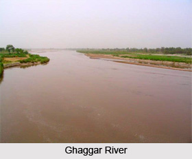
Further, the alluvial bed of Ghaggar River is characterised by a clayey surface of almost flat, featureless plain. It is bordered in the north and west by Haryana Plain and in the south along the sand dune tract, is a manifestation of the misfit nature of the present day Ghaggar. Water logging is a serious problem in many parts of this flat surface of impervious clay of great thickness. At places, swamps support a high density of tall grass. The third tract that is the sand dune tract covers the southern most part of Sirsa District. The area is northward extension of the sand dunes of Hisar District and Ganganagar District of Rajasthan. These dunes are locally called `tibbas`. All tibbas are broad based transverse ridges, some more than 3 kms long without a break. Linear to complex ridges, short to fairly long but narrow at the crests, and generally 2 to 5 meters high are also present throughout the sandy stretch of the land. These are some of the important features constituting the geography of Sirsa District.
The climate of Sirsa District is relatively dry and has extreme temperature with scanty rainfall. The year may be divided into four seasons. The cold season from November to March is followed by the summer season which lasts up to the end of June. The period from July to the mid of September and from mid September to October constitute the south west monsoon and post-monsoon seasons respectively. The average annual rainfall in the district is 32 mm to 53 mm.
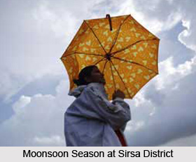 The rainfall in Sirsa District increases generally from west to east. About 72 percent of the annual normal rainfall in the district is received during the short south east monsoon period, July to September, July and August being the rainiest months. The district receives a significant amount of rainfall in the month of June, mostly in the form of thunder showers. In the rest of the year, there is very little rainfall. On an average there are 20 rainy days in a year in the district.
There is a rapid increase of temperature after February. The mean daily maximum temperature during May and June which is the hottest period varies from 41.5 degree Celsius to 46.7 degree Celsius. On individual days the maximum temperature during the summer season may increase up to about 49 degree Celsius. With the advance of the monsoon season into the district, by about the end of June, there is an appreciable drop in the day temperature and the weather becomes cooler during the day time, but the nights are warmer than those during the summer season. With the added moisture in the monsoon air, the nights are often uncomfortable. The decrease in temperature is rapid after October and drop in temperature after nightfall is particularly trying. January is generally the coldest month with the mean daily maximum temperature at 21 degree Celsius and the mean daily minimum temperature at around 5 degree Celsius. Relative humidity in the mornings is generally high during the monsoon season and during the period in between December to February it is usually 70 percent or more. Humidity is comparatively less during the rest of the year, the driest part being the summer season with the relative humidity being about 30 percent in the afternoons.
During the monsoon season, the sky is moderately or heavily clouded. In the rest of the year, the sky is generally clear or lightly clouded. Cloudy sky prevails for brief spell of a day or two in association with passing western disturbances in the cold season. Winds are generally light in the district with some strengthening in force during the late summer and monsoon seasons. During the south-west monsoon season while winds from south-west or west are more common, easterlies and south-easterlies also blow on some days. In the post monsoon and winter season while south-westerly or westerly winds are more common in the mornings, north-westerly winds are predominant in the afternoons. In summer, winds are more common from the west or south-west in the mornings. In the afternoons they are mostly from directions between west and north-west.
Geography of Sirsa District also consists of a special weather phenomenon. Some of the depressions which originate in Bay of Bengal in the south-west monsoon season, and which move across the central parts of the country reach the district during the last stages of activity and cause wide spread rain before dispersing. An occasional post-monsoon storm or depression also affects the district. Thunder storms occur throughout the year but the highest is during the monsoon season. Dust storms occur often during the hot season. Moreover, occasional fogs affect the district in the cold season.
Administration of Sirsa District
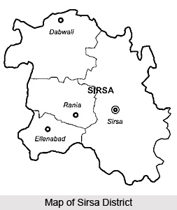
The Sub-Divisions of Sirsa District are Sirsa, Dabwali and Ellenabad. Further, administration of Sirsa District includes four tehsils namely Mandi Dabwali, Sirsa (with Kalan Wali and Nathusari Chopta as Sub-Tehsils), Rania and Ellenabad. There are seven community development blocks in Sirsa District and these are Baragudha, Mandi Dabwali, Ellenabad, Nathusary Chopta, Odhan, Rania and Sirsa.
Culture of Sirsa District
Culture of Sirsa District is vibrant and reflects the rich tradition of the district. The people in the district still continue to follow the old festivals and traditions of observing Amavasya and Purnmashi in Lunar Month. The most significant festivals celebrated here are Teej, Raksha Bandhan, Janmashtami, Dussehra, Diwali, Makar Sankranti, Vasant Panchami, Shivaratri, Holi, Id-ul-Fitr , Id ul Zuha, Muharram, Ramnavami and many more. All these festivals in the district as elsewhere are celebrated with full devotion and joy. Most of the fairs are of religious origin; however, they also exhibit a bit commercial colour as thousands of people participate. Moreover, a fair popularly known as Mela Ram Dev is held annually at this place. Another socio religious fair called Baisakhi fair is held at Sirsa town in the month of Baisakh.
Fairs and Festivals of Sirsa District
 Fairs and festivals of Sirsa District are the traditional religious events which have been followed since ancient times, while observing `Purnmashi` and `Amavasya`, during the lunar month. The full moon night is referred to as Purnmashi. Some of the most popular festivals celebrated here include `Teej`, `Gangor`, `Raksha Bandhan`, `Dussehra`, `Janmashtami`, `Shivaratri`, `Gugga Naumi`, `Sankranti`, `Diwali`, `Holi`, `Ram Navami` and `Vasant Panchami`. The other festivals observed here are those celebrated by Christians, Muslims and Sikhs.
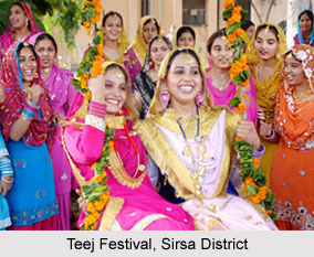
Teej Festival
The festival of Teej is an important festival of Sirsa district and is observed in the month of `Sawan`, which falls from the months of July to August. The festivities continue till another grand festival named Gangor arrives.
Kartik Snan
Kartik Snan is mainly observed by the regional girls of Sirsa district and is held during `Kartik` month, which falls during the months of October and continues till November. Girls worship Lord Krishna for an entire month, after taking bath in the village pond, at dawn. Thereafter, they go for their ritual `Ganga Snan`. Legend states that Kartik Snan is associated to Lord Krishna, who had promised `Gopis` that he would visit them during Kartik month. The girls also create an idol of `Sanjhi` on the walls of their homes, with the aide of clay and adorn it with jewels and ornaments ten days prior to Dussehra. They then sing songs, appreciating Sanjhi, until her idol is immersed into the waters of the village pond during Dussehra with great honour.
 Goverdhan Puja
This Puja is offered just after the festival of Diwali, wherein cowdung is collected in the courtyard of houses. Like Kartik Snan, even Goverdhan Pooja is connected to Lord Krishna.
Sankranti
Sankranti is celebrated in the month of `Magh` which is arranged during January to February. Taking a bath in the morning, cleansing homes and offering gifts to the elders of the family form a significant part of this festival.
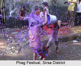
Phag
This festival is observed on the day immediately after Holi. People engage in playing with `korda`, water and colours during Phag. In Phag festival, the regional men throw colours and water on the womenfolk and are then chased by them. The women then tease the men by offering them pleasant beating. The festive fervour continues throughout the night.
Gangor
The Gangor festival is celebrated during the months of March and April and is accompanied with some festivals and fairs. During Gangor, idols of Gangor and Ishar are ushered out in a grand procession. Songs are sung until the idols are immersed in water.
Mela Ram Dev
This is a special fair which is conducted at Ellenebad, Ludesar and Kagdana in the month of `Magh` during the months of January till February. Mela Ram Dev is held in the honour of Ram Dev Ji Maharaj, who is believed to have been a saint belonging to the region of Runicha, located in the then State of Bikaner. The saint is a descendant of the Tanwar- Rajput clan.
Mela Sacha Sauda
Mela Sacha Sauda is conducted at Sirsa town on the first Sunday of every month at the areas of Jagmalwadi and Shahpur Begu. This great fair is celebrated in the memory of a `fakir` named Shah Mastana who taught the moral virtues of justice and gratefulness to people.
Mela Baba Bhuman Shah
This fair is held at the regions of Gidranwali, Moujdin, Kuta Badh and Mangala and the time of celebration of this fair differs from one place to the other. Frequently, the fair coincides with the visit of Baba Bhuman Shah, who belongs to Kamboj community.
Hola
Hola is yet another socio-religious fair which is observed at Jeewan Nagar during the month of March to April. People belonging to the Namdhari sect celebrate Hola and weddings amongst this sect are arranged during Hola.
Baisakhi Fair
The Baisakhi Fair is arranged with gaiety on 13th April, in the month of `Baisakh`. On the day of celebration of this fair, another fair known as Mela Baba Boota Singh is also observed to commemorate the Baba.
Mela Shah-Bu-Shah
This is a grand fair which is celebrated at Panihari during August till September, to honour a Muslim saint called Shah-Bu-Shah. The regional inhabitants of Sirsa district worship the Samadhi of this Indian saint during this occasion.
Gugga Fair
Gugga Fair is observed at the region of Chautala on Bhadon Badi which is observed during the month of August to September.
Forests in Sirsa District
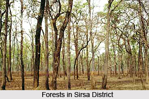 Forests in Sirsa District are known as `Northern Tropical Thorn Forest` and some of the trees existent in this Indian district include Kair (Capparis deciduas), Jand (Prosopis cineraria), Pipal (Ficus religiora), Jaal (Salvadora oleoides), Reru (Acacia lucophloea), Neem (Azadirachta indica), Beri (Zizyphus mauritiana) and Lasura (Cordia dichotoma) amongst numerous others.
A vast amount of forest lands which previously thrived in Sirsa District are presently non-existent and the main areas of vegetation are located near railway lines, in the form of strips. The Forest Department of Sirsa District has ensured that various species of trees are planted here, for instance Prosopis juliflora (Vilayati Kikar), Acacia tortilis (Israeli Kikar) and many others. Several Shisham and Eucalyptus trees have been planted near the side of canals, since the soil in those regions possess a high water level. Kikar tree grows near the roads where the soil contains lower moisture levels and higher pressure. Acacia tortilis is found alongside the border of the state of Rajasthan, as it can withstand soils which has an extremely low quantity of moisture and experiences low rainfall which is lower than 30 cm per year.
Since the water table is gradually increasing in certain portions of the district like Surtia, Nathusari Chopta, Phaggu and Rori, it renders the soil infertile and incapable of supporting the cultivation of agricultural crops. This is due to the fact that the rising water table makes the soil completely saline. Eucalyptus, which is also known as `Biodrain` thrives in such regions since it easily is capable of tolerating saline soils. Sirsa district boasts of the highest number of Shisham trees in Haryana. Numerous Shisham trees had been planted in this area during the 60`s and 70`s, which have grown into tall, beautiful trees.
India Forest Act, 1927 have proclaimed these forests as protected forests. The forest of PACCA is the one and only reserve forest located in Sirsa. According to the National Forest Policy, about 20% of the area under plains had been aimed to be covered by vegetation. Efforts are being made in order to expand the natural vegetation of Sirsa District.
The older trees of this region are constantly dying due to the excessive utilization of nitrogen fertilizers and other human activities.
Archaeological Interests in Sirsa District
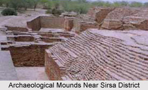 Archaeological interests in irsa District portray the ancient culture, traditions and history of this part of the country, as revealed by the excavations conducted at several sites in this district. Excavations in about 54 sites have been conducted by the Archaeological Survey of India, particularly in Ghaggar Valley during the period of 1967 to 1968. Various artefacts belonging to the Rang Mahal culture were unearthed, which include red, black and grey wares and different types of pottery.
Arnian Wali
Arnian Wali is located at a distance of 8 km from the southern part of Sirsa, on Sirsa Bhadra Road. A mound which measures 4 acres and 10 feet in height is situated at a distance of nearly 400 meters from the northern portion of the village. Remnants of pottery belonging to the ancient and medieval ages are also existent here.
Sikander Pur
Sikander Pur is based about 12 km from the eastern portion of Sirsa and this village can be accessed via Sirsa- Fatehabad Road. There are two mounds found here, which are quite famous. They are 10 km apart from each other and are present at a distance of 1.6 km from the north-eastern portion of the villages. They measure nearly 30 feet in height. Excavations have also helped discover some instances of a temple of medieval period as well as heavy stone slabs. A sculpture of Lord Indra as `Dikpala` also exists in this part of the nation. An `Ekmukhi Linga` of Lord Shiva of medieval age can also be found here. Remains of Rang Mahal culture and wares are also significant archaeological interests of Sirsa district.
Suchan
Suchan is situated nearly 16 km from the eastern part of Sirsa District and boasts of pieces of pottery wares and paintings from medieval times.
Mangiana
Mangiana is situated at a distance of about 13 km from the eastern portion of Dabwali on the Kalanwali-Dabwali Road. The mound found here is about 15 feet in height.
Amongst the several ancient objects discovered by these excavations, a mound known as `Laharonwali Theri` and utensils like bowls and dishes are worth mentioning. Apart from these, two mounds at the region of Sikanderpur bear testimony to the fact that they belong to the culture of Rang Mahal.
Tourism in Sirsa District
 Tourism in Sirsa District, which is located in the northern Indian state of Haryana involves some thrilling tourist locales which mainly comprises religious places.
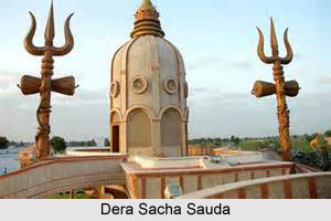
Dera Sacha Sauda
Dera Sacha Sauda is situated on Shahpur Begu Road and was believed to have been established by a saint named Shah Mastana in the year 1948. The Dera is based inside the premises of a large building and possesses 600 rooms, a gigantic ground and a hall. `Langar` or a free kitchen is also arranged at times inside Dera Sacha Sauda.
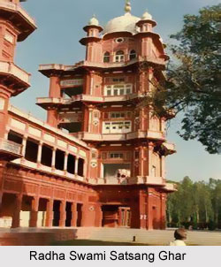
Radha Swami Satsang Ghar
At village Sikanderpur, which is located at a distance of nearly 5 km from the eastern part of Sirsa, there exists a vast Satsang Ghar known as Radha Swami Satsang Ghar. It is conducted during March to April every year.
Ram Dev Temple
This temple is dedicated to Ram Dev, a saint belonging to the western Indian state of Rajasthan. It is located in Sirsa Tehsil, in Kagdana and is one of the largest temples of the saint Ram Dev. A grand fair is conducted during the month of March every year.
Dera Jiwan Nagar
Dera Jiwan Nagar is situated at a distance of about 30 km from the western portion of Sirsa and is revered by the Namdhari sect. Initially, Dera Jiwan Nagar was referred by this name to honour Jeewan Kaur, the mother of a Namdhari saint known as Partap Singh.
Hanuman Temple
Hanuman Temple is located about 2 km from the western part of the city, particularly in Ram Nagria.
Gurudwara Guru Gobind Singh
Based in Chormar Khera village in Tehsil Dabwali, which is located on Delhi -Fazklika National Highway at a distance of nearly 36 km from Sirsa, this Gurudwara is dedicated to Guru Gobind Singh. He is said to have resided at this place for a night. The total area occupied by Gurudwara Guru Gobind Singh measures about 8 acres. The tank present here boasts of separate enclosure for women. A library and museum are also existent in the premises of this Gurudwara.
Dera Baba Sarsai Nath
Dera Baba Sarsai Nath is situated outside Hisar Gate and the construction of this ancient temple is believed to have been accomplished during the 13th century. Sarsai Nath, who was a saint of Nath sect is said to have built this temple. This saint had meditated at this place.
Saint Baba Bihari Samadhi
This Samadhi is present in the western portion of Sirsa, surrounded by a marvellous garden and a temple. A `Bhandra` is celebrated on 1st January every year, in the premises of the temple which is close to the Samadhi.
Dera Sufi Saint Baba Bhuman
Mangala, Mallewala and Sangar Saritha are some of the villages which consist of the Deras of renowned Sufi saint Baba Bhuman Shah. These Deras belong particularly to Kamboj. During `Sankranti`, a fair is conducted every year at these deras.
Tomb of Khawaja Pir
The Tomb of Khawaja Pir was built to commemorate Khawaja Abdul Shankar during the 13th century. Khawaja Pir was amongst the people who had accompanied Muhammad Ghori to the country of India and had decided to continue to dwell here. In 16th century, a mosque was erected near the Tomb. Presently, however, one will not find any remnants of the Tomb or mosque. According to a legend, Guru Nanak is believed to have resided here for a period of 40 days at the Tomb. He was accompanied by Madana and Bala, who were his disciples.
Jama Masjid
Jama Masjid was built by Sheikh Yasaf of Hisar, during the regime of the Mughal emperor, Babar, as revealed by the inscriptions on the walls of the Jama Masjid. There are two minarets on this mosque which overlooks the town.


