 Geography of Khandwa (East Nimar) district is very favourable with a pleasant and healthy climate. The district is located to the South-West of Madhya Pradesh and it is in the Indore division of the state. The minimum and maximum height above mean sea level is 180.00 meters and 905.56 meters respectively. This district is bounded on the east by Betul District and Hoshangabad district of Hoshangabad division, Burhanpur district of Indore division on south, on the west by West Nimar district of Indore division and on the north by Dewas district of the Indore division. The total area covered by this district is about 6206.45 square kilometers.
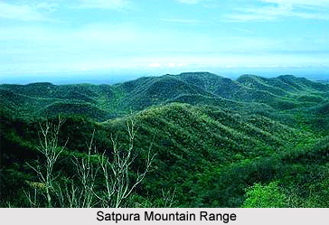
The district of Khandwa (East Nimar) is situated between the two major rivers; the Narmada River and Tapti River. These two rivers are flowing parallel to each other from east to west through this district. The Hatti hill range borders and overlooks the Tapti valley in the south throughout its length in the district. The major natural divisions of this district correspond to the two distinct physiographic divisions, viz., the Narmada Valley and the main Satpura Mountain Range.
The Narmada flows through the northern parts of the Khandwa (East Nimar) district, roughly in an east-west direction. Among the streams joining the Narmada within the district from the North are Khari and Kanar (Lohar). These are the only perennial streams in the tract. The hills in the Chandgarh and Selani tracts rise conspicuously from 61 meters to 152 meters above the adjacent plains. The general height of Selani tracts is about 228 meters and that of Chandgarh is about 285 meters. The north-south chain of hills in Chandgarh and Selani tracts continues across the Narmada in the south. The southern tributaries of the Narmada flow towards north or north-west, revealing the general slope of that part of Narmada Valley, which lies within the district. The average height in the eastern part of valley is about 243 meters. The plain country in the extreme west, below Mandhata, lies at a level of about 213.4 meters above mean sea level. The catchments area of the Chhota Tawa is at about 304.8 meters above mean sea level.
The Satpura Mountain Range is the name given collectively to a complex system of ranges and high lands about 600 miles long and 100 miles wide. It lies to the south of the Narmada River Valley from the western coast of India to the Amarkantak hills in the east. This system includes ranges as far south as the southern Maikal hill or Saletakeri hills. The Tapti River flows in a narrow valley between two parallel ranges of the Satpura in the southern parts of this district. It stretches to about 50 miles from East-North to West-Southwest.
The climate of Khandwa (East Nimar) district in the state of Madhya Pradesh is very pleasant and healthy. The district falls in the drier parts of India. The average annual rainfall received by this district is 980.75 millimetres. The northern part of Khandwa (East Nimar) district receives more rainfall than the southern part. The monsoon season starts approximately by the 10th of June every year and extends up to early October. The days are quite humid. The maximum temperature recorded in this district is in the month of May, which is 42 degrees Celsius and minimum temperature recorded in the month of December as 10 degrees Celsius.


