Home > Travel > States of India > Burhanpur District
Burhanpur District
The Burhanpur District, which was born on August 15,2003, harbours a number of mosques as signatures of the Muslim rule.

Share this Article:

Burhanpur District,Madhya PradeshBurhanpur District is a district of the state of Madhya Pradesh in the central part of the Indian subcontinent. The town of Burhanpur is the district headquarters. The Burhanpur District came into being on August 15, 2003, from the southern portion of the Khandwa (East Nimar) District.

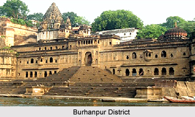
History of Burhanpur District
History of the Burhanpur District goes thus. In 1536 A.D., one of the Mughal Emperors of India, Humayun, after his conquest of Gujarat, came to Burhanpur District and Asirgarh via Baroda, Broach (Bharuch) and Surat. At that time Raja Ali Khan, was asked to surrender to Akbar, when the latter had sent an expedition to Khandesh, in the summer of 1577 A.D. Raja Ali Khan gave away his royal title of Shah and accepted the dominion of Akbar. This marked an age in the Deccan policy of the Mughals, for Khandesh was used as a foundation for the future Conquest of Deccan. Raja Ali Khan constructed many buildings like Jama Masjid in the upper portion of the fort of Asir in 1588 A.D. However, Bahadur Khan (1596-1600 A.D.) successor of Raja Ali Khan affirmed his independence and declined to pay homage to Akbar and his son Prince Daniyal, which enraged Akbar, who marched towards the Burhanpur District in 1599 and occupied the city of Burhunpur without any opposition on 8th April 1600 A.D.

Later, Prince Khurram was designated as the Governor of the Deccan in 1617 AD, by Jahangir to succeed Prince Parviz, and was bestowed the title of Shah by Jahangir. After the death of Jahangir in 1627, Shah Jahan ascended the throne of Mughal Dynasty. Due to atrocities in the Deccan, he reached the present day Burhanpur District on 1st March 1630, where he stayed for the next two years, conducting operations against Bijapur, Ahmadnagar District, and Golconda. On 6th March 1632, Shah Jahan left Burhanpur for the north, after assigning Mahabat Khan as the Viceroy of the Deccan.

During the reign of the British East India Company, it can be found that the Burhanpur district was affected by the Sepoy Mutiny 1857 against the British rule, which also spread over the rest of the country. The district was also greatly affected by the Non-Co-operation movement, the Civil Disobedience movement, the Quit India Movement and the like from the close of the 18th century until 15th August 1947.

Geography of Burhanpur District
The Tapti River flows through the district from east to west. The Satpura Mountain Range divides the district into the Khandwa District on the north, which is also the demarcating line between the Narmada River valley and the valley of the Tapti. There is a pass through the Satpuras that links Burhanpur and Khandwa. This pass is one of the main routes linking northern and southern India. The pass has the Asirgarh fortress, which is also known as the "Key to the Deccan".


Share this Article:

Related Articles

More Articles in States of India


East Indian States
East Indian States comprises of Bihar, Jharkhand, West Bengal, Odisha and also the Union Territory of Andaman and Nicobar Islands. It defines the cultural heritage, rich historical background and the linguistic unity.
Erode District
Erode District is one of the districts in the state of Tamil Nadu. The district of Erode is having a land-locked area with no sea coast.
Purnia District in Bihar
Purnia District is located in Bihar and extends from River Ganga to Nepal. The district has a rich Hindu history and glorious past.
South Delhi District
South Delhi District is the third largest district of Delhi as far as its area is concerned. South Delhi District is known for its economic, historical, cultural and social significance.
North Indian States
North Indian States formed the cultural and religious unity in spite of having many foreign invasion and the political disturbances from the early era till the British gained supremacy in Indian sub continent.
Kendujhar District
Kendujhar District, spread over an area of 8,240 sq kms, is as varied as the whole of Orissa with waterfalls roaring gorges, mountains and minerals. The manifold expressions of nature in Kendujhar District are considered as unique.
Hooghly district
Hooghly District along the bank of the river Hooghly is one of the principal trading ports of West Bengal.
Districts of South Tamil Nadu
Districts of South Tamil Nadu consist of many tourism destinations like archaeological sites and the history of Pandyas and Cholas. Considering their proximity to the sea, many districts also boast of serene beaches and coastal beauty.
Flora of Arunachal Pradesh
Flora of Arunachal Pradesh includes infinite species and is a subject of great interests for the botanists.
Districts of South Gujarat
Districts of South Gujarat are the epicenter of Jain pilgrimages and the early Hindu kingdoms.
North West States of India
North West States of India consist of three states, which are Rajasthan, Punjab and Haryana. All of them are culturally and traditionally diverse and they have been ruled by different dynasties in historical time.
Geography Of Chittoor District
Geography of Chittoor district is spread along the topography of the land which is divided into two natural divisions; Chittoor has a dry and healthy climate.
Districts of North Rajasthan
District of Northern part of Rajasthan is dotted with ancient forts and medieval villages.
Districts of North Odisha
District of North Odisha has Bengal boundary and shares the same culture. These are reachable if one pays a weekend visit to Digha.
Districts of West Bihar
Districts of West Bihar is comprised of medieval monuments that were built by the different governors of Mughal era.
Districts of South Haryana
Districts of South Haryana consists of many cities of industrial excellence. These districts are dotted with popular tourism destinations.
Medieval History of Assam
Medieval history of Assam narrates the advent and rule of a number of kingdoms in the region. The prominent dynasties of the kingdom left an everlasting imprint on the socio cultural heritage of India.
Geography of Meghalaya
The suitable climate, highland plateaus, rivers and the flora and fauna together forms the geography of Meghalaya.
Districts of Rayalaseema
Districts of Rayalaseema in Andhra Pradesh state has urban population and rural settlements as well.
Districts of South Punjab
Districts of Southern part of Punjab depict medieval history of Punjab and the rise of Sikhs.