Introduction
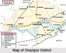 Ghazipur District forms the eastern part of the Varanasi Division in Uttar Pradesh. Ghazipur is the district headquarters. It lies to the east and north of Jaunpur and Varanasi district respectively. Ghazipur District is situated between the parallels of 25 degree 19 minutes and 25 degree 54 minutes north latitude and 83 degree 4 minutes and 83 degree 58 minutes east longitude. This location is around 67.50 metres above the sea level. The length of district from east to west is 90 kms and width from north to south is 64 kms. Ganga River from one side and Karamnasa River from other side divide it from Bihar. It is bounded by Ballia District and Bihar in the east, Jaunpur, Varanasi and Azamgarh in west, Mau in north and Chandauli District in the south. The boundaries are generally conventional though at places they are marked by natural features. The common language used by the people is Bhojpuri language.
History of Ghazipur District
Ghazipur District was constituted a separate district in 1818. Originally the district was very big, including not only modern Ballia but also Narwan of Varanasi, Chausa of Buxar (Bihar) and Pargana of Sagari, Ghosi, Mau and Muhammadabad in Azamgarh District. Early history of Ghazipur District dates back to Vedic and Ramayana era. It states that this region was covered with dense forests and many Ashrams were situated here. It was an important centre of Lord Buddha`s preaching.
 According to the history of Ghazipur District (that is known as Gadhipuri) this region was known as Garjpuri in ancient times. Eventually, it changed to Ghazipur and it was an important centre for British rule and it also played an important role in Indian National Movement. Interestingly, Ghazipur does not figure as such in ancient Indian History. Further, historical accounts state that Ghazipur District was covered with dense forests in Vedic era and it was a place for Ashrams of Saints during that period. This place is also associated with Ramayana period. Famous Rishis Gautam and Chyavan were given teaching and sermon here in ancient period. Lord Buddha gave the first sermon in Varanasi, which is not very far from here. The Aurihar area of Ghazipur District became the main centre for teaching of Lord Buddha. Many remnants and pillars are the main evidences of that period. Ghazipur District was an important centre during Buddhist period.
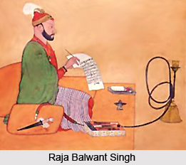
Moreover, the history of Ghazipur District says that this place was the main centre in medieval period from Sultanate period to Mughals. In Tughlaq period Muhammad Bin Tughlaq established Jaunpur as the capital under which Ghazipur was ruled. Further, in his regime, Syed Masood Ghazi established this town by defeating Raja Mandhata. In Lodi Period, Naseer Khan Nuhani was the administrator of Ghazipur who changed its conditions. This region was the main centre during Mughal period when Babur took over the charge of Ghazipur and Muhammad Khan Nuhani became its administrator. In the reign of Akbar, Afghan Ali Kuli Khan took over the charge of Ghazipur and developed the town Zamania. After the death of Aurangzeb this area was taken by Jamindar Mansa Ram. Thereafter, Ghazipur came under the sovereignty of Banaras state and Raja Balwant Singh, son of Mansa Ram became the king of Ghazipur. Ghazipur District came into being in the year 1818.
After the attack of Warren Hastings, the then Governor General of British rule, this area was ruled over by several British rulers. Ghazipur District played an important part in the freedom struggle of the country. This is the native land of several freedom fighters like Mangal Pandey. Famous Nilha Sahib Revolt is associated with this place where the farmers revolted against the British rulers. After the independence of the country, Ghazipur District could not develop as it used to be in the past.
Geography of Ghazipur District
Ghazipur District is garlanded by Ganga, Karamnasa and Gomti, that makes this region stronger in economic and geographic condition. The total geographic area of this district is 3384 sq kms. Ghazipur is embellished with picturesque geographical environs. Geography of Ghazipur District is a part of mid Gangetic plains. Total area is approximately 3, 33,209 Hectares in which 2, 52,824 Hectare is for agriculture purpose. Approximately 38 percent of soil is cattle field. This district does not contain any forest area.
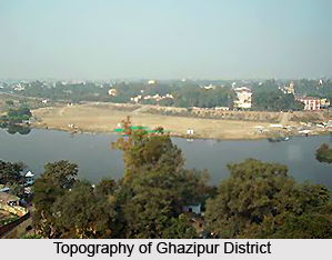 Geography of Ghazipur District includes general slope from north-west to south-west. This being the direction generally taken by subsidiary drainage lines though the Ganga River itself leaves the district in higher latitude than at its point of entry, while north-easterly course of Karamnasa River points to the existence of a reversed slope on the south bank of the Ganga. The soil and the general topography of Ghazipur district depends directly on the drainage lines.
Ghazipur District is situated in eastern part of Uttar Pradesh; hence the climate of Ghazipur is not very hot or cold. The coldest months here are December-January and the hottest months are May-June. The temperature varies from 5 degree Celsius to 17 degree Celsius in winters and 30 degree Celsius to 42 degree Celsius in summers. The south-west monsoon advances and covers the district around June-end and rainy season begins and lasts till October. The average annual rainfall in Ghazipur District varies between 800 mm to 1200 mm. Further, during July and September the relative humidity is high being over 70 percent. During the Post-Monsoon and winter season the humidity is high in the morning and in summer season, relative humidity become very low almost less than 25 percent.
Ghazipur District can be divided in three physical divisions - northern uplands, central lowlands and southern uplands. The northern uplands which comprise the northern portion of Ganga, with exception of parts of Saidpur and Ghazipur and the greater portion of Muhammadabad mostly resemble the ordinary uplands of Gangetic plain. The higher levels are sandy and on the slopes in and from banks of streams the soils become fertile loam but in the depression this merges into stiff clay. The light sandy soil is generally known as Balua, the loam as Doras and clay as Matiyar. In most parts of the uplands there is a large amount of kankar in subsoil. The alluvial lowlands, generally known as terai, comprise a small portion of Saidpur and Ghazipur, and Zamania and Muhammadabad tehsil. Here the soil varies from the sand found on the banks of Ganga to fine loam deposits left by rivers and the characteristic dark soil. The central portion of Zamania constitutes the southern uplands of the district which have the ordinary loam and clay soils of the northern uplands. There is a stretch of fertile Karail on the north of Karamnasa River from the boundary of Varanasi on the west of village Dewal on the east.
Several perennial rivers traverse through the district. The main rivers are River Ganga, Gomti River, Beson, Magai, Bhaisai, Tons River and Karamnasa River. Forest area in Ghazipur District is very small. All the forests in the district are under the control of Gram Sabha. The trees which are found in these forests are of the ordinary varieties common to entire Gangetic plain. As the district lacks dense and extensive forests the number of wild animals and variety of species are small. The birds of the district are the same as those of adjoining district.
Administration of Ghazipur District
 Administration of Ghazipur District has five sub-divisions namely Sadar, Saidpur, Zamania, Muhammadabad and Jakhania each also forming a tehsil of same name. Tehsil Saidpur constitutes the western sub-division of the district. Tehsil and sub-division Ghazipur constitutes the central part, tehsil Muhammadabad forms the north eastern subdivision and extends eastward from the border of Ghazipur to boundary of Ballia. Tehsil Zamania forms the south western subdivision, Jahkhnia sub-division, a newly constructed tehsil located in north western part of the district. Ghazipur District consists of 16 Development Blocks, 193 Panchayats and 1046 Gram Sabhas. It also includes a total 2583 inhabited villages and 781 uninhabited villages. In Urban sector there are 3 Nagar Paika Parishad (Ghazipur, Muhammadabad, and Zamania) and five towns (Saidpur, Jangipur, Dildarnagar, Sadaat and Bahadurganj). There are 23 Police Stations in Ghazipur District.
Education in Ghazipur District
Literacy rate in Ghazipur District is around 59.55 percent, out of which male literacy rate is 74.87 percent and female literacy rate is 42.36 percent. Education level is also standard in the district. Ghazipur District has several Post Graduate College, Government Homeopathic College, Government Poly-technique College, Government Industrial Training Institute, Technical Education Research Institute, Unani Medical College and many other educational institutes.
Culture of Ghazipur District
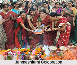
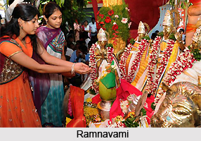
Culture of Ghazipur District is rich and vibrant. It is composed of traditional beliefs, fairs, festivals, music and folk dances. Makar Sankranti, Janmashtami, Ramnavami, Ganesh Chaturthi, Holi, Id Ul Fitr, Muharram, Id Ul Zuha are some of the main festivals celebrated in the district. Near about 32 fairs are held in different parts of the district on various occasions.
 Ghazipur District has a rich cultural heritage and it is also known for its bravery and spiritual glory. Culture of Ghazipur District including its music and dances is quite similar with that of Bihar. Dhobia and Purbi Nautanki are very famous folk dances of Ghazipur District. Ghazipur is the native land of several renowned musicians. Among the communal dances Phari or Pharia is organized at the time of marriages and other occasions. This district of Uttar Pradesh is known for producing dancers of national repute. Among the rural folk, recitation of stories and legends and singing are very common. Performances like Nataks and Nautanki, Bhajan Kirtan, recitation from Ramayana and other religious stories, etc. constitute the vibrant and colourful culture of Ghazipur District.
As Ghazipur District is the main centre of Ganga-Jamuni culture from its past, so festivals of all religions are celebrated in this district. Raksha Bandhan, Baisakhi, Ganga Dussehra, Nag Panchami, Makar Sankranti, Janmashtami, Ramnavami, Ganesh Chaturthi, Vijaya Dashami, Diwali, Kartik Purnima, Vasant Panchami, Shivaratri, Holi, Id Ul Fitr, Muharram, Id Ul Zuha, Barawafat and Shab-e-Barat are the main festivals celebrated here. Buddha Jayanti, Mahavir Jayanti, Guru Nanak Jayanti are also celebrated. Ghazipur District also reflects a touch of rural culture so many local level festivals and fairs are celebrated with full enthusiasm and joy.
In Ghazipur District near about 32 big and small fairs are held annually. Celebrations of most of the festivals are accompanied by local fairs as well. Of these the Dhanush Yagya fair is a prominent fair of this district held at village Katghara in Saidpur. Ramlila fair is another important one. Govind Dashami fair at Jafarpur, Navratri Fair, Trimohini fair at Jalapur and Goril Baba fair are also considered prominent. Fair at Jamdagni Rishi Ashram is also very popular. Large numbers of devotees come here on the occasion of Kartik Purnima and Makar Sankranti every year. Mauni Baba fair at Chochakpur holds tremendous significance. It is held at the temple of Mauni Baba that is situated on the banks of Ganga River in Chochakpur just 17 kms from district headquarters at Ghazipur and a large number of devotees assembles on the day of Kartik Purnima.
Tourism in Ghazipur District
In Ghazipur District there are several places worth exploring. It is one of the popular tourist destinations of Uttar Pradesh. Aunrihar, Bhitari, Bahadurganj, Ghazipur, Dildarnagar, Gauspur and Zamania are some of the noteworthy places of interest in this district. These places have historical as well as religious importance.
 Tourism in Ghazipur District offers visits to various places having historical and religious importance. The tourism options offered by Ghazipur District attract people from all corners of the country. Tourism in Ghazipur District offers a memorable and enriching experience to the travellers.
Some of the prominent places of interest of Ghazipur District are as follows -
Aunrihar: Aunrihar is situated is situated in the west of Ghazipur city and about 3.2 kms from Saidpur. This place is archaeologically interesting. Moreover, it is one of the oldest and most important sites in the district. The whole surface of the ground of Aunrihar is strewn with fragments, large carved stones and fine pieces of sculpture. Every few yards traces of ancient masonry wall can be seen.
Bahadurganj: Bahadurganj town is situated on the bank of River Saryu. It is at a distance of about 35 kms from Ghazipur. The place is said to have been founded in 1742 AD by Sheikh Abdullah, who also built a large fort here. A small fair is held in this ancient town on the occasion of Ramnavami.
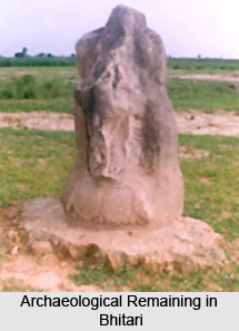
Bhitari: Bhitari is situated about 32 kms form Ghazipur near Saidpur town. The name Bhitari is popularly derived from Bhimutri. Bhitari is archaeologically very important. It is a place of great antiquity and contains many remains of great archaeological value. It is probable that Bhitari was at one time in hands of Buddhists but it probably attained its chief importance during Gupta Era. The most noticeable relic of that era is the famous monolith of red sandstone standing in the fort enclosure on the block of ruff stone. Bhitari was probable one of the royal residences of Gupta Kings.
 Dildarnagar: Dildarnagar lies on the road from Varanasi and Zamania to Buxar and 20 kms from Ghazipur. This is an ancient town of Ghazipur District.
Gauspur: Gauspur, a large village, is situated 14 kms from Ghazipur. In Gauspur traces of Hindu civilization, large masses of stone and old bricks have been discovered. Several striking pieces of Hindu sculpture are also found.
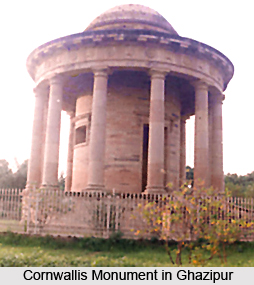
Ghazipur: History of Ghazipur dates back to the days of its traditional foundation by Syed Masood in 1330. According to legend the ancient name of city was Gadhipuri. The Cornwallis monument is one of the major attractions of this town. It is a heavy structure with a domed roof supported on twelve Doric columns. The floor is around four metres higher than the ground and is of gray marble. In the centre there is a cenotaph of white marble. As Ghazipur is situated on the banks of River Ganges, hence there are some beautiful ghats to be explored in this city.
Zamania: It is an old town founded in 1560 by Ali Quli Khan. According to Hindu tradition, it derived its name from the name of Rishi Jamadagni.
These are some of the historical towns of Ghazipur District. These places are worth visiting.
How to Reach Ghazipur District
Ghazipur District is situated in the eastern most part of Uttar Pradesh, close to holy city Varanasi. It is well connected with major cities of the country by railways. This place is about 75 kms from Varanasi. Nearest airport is Babatpur in Varanasi, which is just 70 kms away from here, from where daily flights for all the major cities are available. Bus service from Varanasi, Allahabad, Lucknow and Gorakhpur is available frequently. As it is situated on the main route from Varanasi to Chhapra on Broad Gauge Line, hence it is well connected with Delhi, Mumbai and Lucknow through train.


