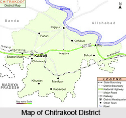
 Chitrakoot District, an administrative district of Uttar Pradesh, is a part of Chitrakoot Division. It lies between latitude 24 degree 48 minutes to 25 degree 12 minutes north and longitudes 80 degree 58 minutes to 81 degree 34 minutes east. Chitrakoot District is bounded in the north by Kaushambi, in the south by Satna (Madhya Pradesh) and Rewa, in the east by Allahabad and in the west by Banda. Total area of Chitrakoot District is 345291 sq kms. Farming is the main business of Chitrakoot District and majority of the people depend on it. However, some small scale industries also exist in the district. Distance covered by Chitrakoot District from east to west is 62 kms and from north to south is 57.5 kms.
History of Chitrakoot District
Chitrakoot district was created on 6th May, 1997 and had been carved out from Banda district. It falls in the northern Vindhya Range of mountains spread over the states of Uttar Pradesh and Madhya Pradesh. The larger part is included in this district. The word `Chitrakoot` has been used to refer to this larger area and symbolises its rich and varied cultural, religious, historical and archaeological heritage. Chitrakoot is a holy place famous both for its natural scenery and its spiritual altitude.
Geography of Chitrakoot District
The main rivers of Chitrakoot District are Yamuna River, Mandakini River, Gunta River, Bagein River, Ohan River, Balmiki River and Bardaha River. There are many mountains in Tehsils Karvi and Mau of the district. Main mountains are Madfa Pahar (this mountain is situated in Karvi Tehsil), Chitrakoot Parvat Mala and Balmiki Pahar. In Chitrakoot District, mainly five types of soils are found namely Kankirili Soil, Kabar Soil, Balui Soil, Rakad Soil and Padua Soil. The district has there main seasons; winter, summer and rainy.
Administration of Chitrakoot District
Administrative set-up of Chitrakoot District includes two Tehsils; Karwi and Mau. Further, there are five Development Blocks in Chitrakoot District, and these are Chitrakoot Dham Karwi, Ramnagar, Mau, Manikpur and Pahadi. Deputy Commissioner is the head of the administration of Chitrakoot District.
Ramayan Mela, Chitrakoot Mahotsava and Diwali Mela are some of the main fairs organised on different occasions in the district.


