Home > Travel > States of India > Saiha District
Saiha District
Saiha District is located in Mizoram with its headquarters at Saiha town. Initially this district was known as Chhimtuipui District. Pala Tipo Lake is the biggest lake of Mizoram located at Saiha.

Share this Article:

Saiha District, Mizoram
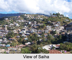
Saiha District is one of the districts of Mizoram. It is situated on the southernmost fringe of the North-eastern region of India and is bordering Myanmar on the eastern and southern side. It has its administrative headquarters at Saiha town. Saiha District is surrounded by Lunglei district on the north and northwest and by Lawngtlai district on the west. It covers an area of 1399.9 sq kms. Saiha District has a total population of 60,000 as per the 2001 census. Saiha, the district headquarters, is the third most developed and also the third most populous town in Mizoram. It is also the capital of the third largest tribe, the Maras in Mizoram.

Administration of Saiha District
Administratively, Saiha District is divided into two blocks namely Saiha and Tuipang. Saiha block has 37 Village Councils and Tuipang block has 41 Village Councils. The district area comes under Mara Autonomous District Council under the Sixth Schedule of the Constitution of India. The Councils function like mini- Legislative Assemblies with powers to pass their own laws and rules, subject to approval by the Administrator (Governor of Mizoram).

Tourism in Saiha District
Saiha District is known for its scenic beauty. There are several tourist spots as well. Some of the popular attractions of Saiha District are as follows:

Pala Tipo (Lake): Pala Tipo or Pala Lake is the biggest Lake in the state of Mizoram and it is situated in the western part of Maraland near Phura. The Lake is surrounded by thick forests.

Saikao: This place is popular for the Missionaries House, which was built around 60 years ago. It is still intact and is one of the most visited tourist places.

Mt. Mawma: It is one of the most visited sites along with the cemetery of the Maraland missionaries.

Visiting Information on Saiha
Saiha is easily accessible from Aizawl as well as other district headquarters like Lawngtlai, Lunglei etc. Lumding Junction Railway Station and Sethlun Heliped at Lunglei are the nearest to Saiha. National Highway 54 passes through Saiha.

This article is a stub. You can enrich by adding more information to it. Send your Write Up to [email protected].


Share this Article:

Related Articles

More Articles in States of India


East Indian States
East Indian States comprises of Bihar, Jharkhand, West Bengal, Odisha and also the Union Territory of Andaman and Nicobar Islands. It defines the cultural heritage, rich historical background and the linguistic unity.
Erode District
Erode District is one of the districts in the state of Tamil Nadu. The district of Erode is having a land-locked area with no sea coast.
Purnia District in Bihar
Purnia District is located in Bihar and extends from River Ganga to Nepal. The district has a rich Hindu history and glorious past.
South Delhi District
South Delhi District is the third largest district of Delhi as far as its area is concerned. South Delhi District is known for its economic, historical, cultural and social significance.
North Indian States
North Indian States formed the cultural and religious unity in spite of having many foreign invasion and the political disturbances from the early era till the British gained supremacy in Indian sub continent.
Kendujhar District
Kendujhar District, spread over an area of 8,240 sq kms, is as varied as the whole of Orissa with waterfalls roaring gorges, mountains and minerals. The manifold expressions of nature in Kendujhar District are considered as unique.
Hooghly district
Hooghly District along the bank of the river Hooghly is one of the principal trading ports of West Bengal.
Districts of South Tamil Nadu
Districts of South Tamil Nadu consist of many tourism destinations like archaeological sites and the history of Pandyas and Cholas. Considering their proximity to the sea, many districts also boast of serene beaches and coastal beauty.
Flora of Arunachal Pradesh
Flora of Arunachal Pradesh includes infinite species and is a subject of great interests for the botanists.
Districts of South Gujarat
Districts of South Gujarat are the epicenter of Jain pilgrimages and the early Hindu kingdoms.
North West States of India
North West States of India consist of three states, which are Rajasthan, Punjab and Haryana. All of them are culturally and traditionally diverse and they have been ruled by different dynasties in historical time.
Geography Of Chittoor District
Geography of Chittoor district is spread along the topography of the land which is divided into two natural divisions; Chittoor has a dry and healthy climate.
Districts of North Rajasthan
District of Northern part of Rajasthan is dotted with ancient forts and medieval villages.
Districts of North Odisha
District of North Odisha has Bengal boundary and shares the same culture. These are reachable if one pays a weekend visit to Digha.
Districts of West Bihar
Districts of West Bihar is comprised of medieval monuments that were built by the different governors of Mughal era.
Districts of South Haryana
Districts of South Haryana consists of many cities of industrial excellence. These districts are dotted with popular tourism destinations.
Medieval History of Assam
Medieval history of Assam narrates the advent and rule of a number of kingdoms in the region. The prominent dynasties of the kingdom left an everlasting imprint on the socio cultural heritage of India.
Geography of Meghalaya
The suitable climate, highland plateaus, rivers and the flora and fauna together forms the geography of Meghalaya.
Districts of Rayalaseema
Districts of Rayalaseema in Andhra Pradesh state has urban population and rural settlements as well.
Districts of South Punjab
Districts of Southern part of Punjab depict medieval history of Punjab and the rise of Sikhs.