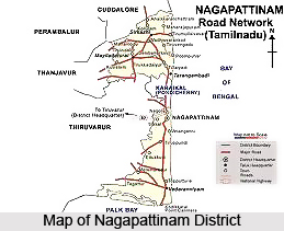
 Nagapattinam district is one of the coastal districts of the state of Tamil Nadu in India. There is the Bay of Bengal on the eastern coast. This district is three hundred and twenty six kilometres away from Chennai, the capital of Tamil Nadu. The Nagapattinam district is located between 10.7906 degree north latitude and 79.8428 degree east longitude. This district of Tamil Nadu is famous for its rich religious heritage and communal harmony. The district of Nagapattinam was carved out by the bifurcation of the previous composite Thanjavur district on 18th October 1991. Nagapattinam is a unique district with all its historical and cultural significance. The district possesses two revenue divisions, seven taluks, four municipalities, eleven panchayat unions, eight town panchayats, and four hundred and thirty four Panchayats. The coastline of this district stretches about one hundred and eighty seven kilometres.
History of Nagapattinam District
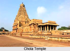 The district of Nagapattinam is one of the constituents of the Cholamandalam, acclaimed as the most prominent among the ancient Tamil Kingdoms. Its salient features more than anything else have contributed to the glory of the Cholamandalam. This region has been named after Kshathiriya sigamani, one of the titles of Raja Raja Chola. Nagapattinam was also known as `Cholakula Vallippatinam`. The heritage of this district is found in the Burmese historical text of the 3rd century B.C. The same text also gives evidences of a Buddha Vihar constructed by the great ruler Ashoka. The Chinese traveler Hieun Tsang also mentioned the Buddha Vihar in his book. Nagapattinam is mentioned as Padarithitha in ancient Buddhist literature.
Geography of Nagapattinam District
The district of Nagapattinam was carved out by the bifurcation of the Thanjavur district in the year 1991. This district has traditionally been referred to as East Thanjavur and Paddy granary of South India. The Nagapattinam District lies on the shores of the Bay of Bengal. This is a peninsular delta district surrounded by Bay of Bengal on the East, Palk Straight on the South and land on the West and Northern side. It is predominantly, a coastal district having a large coast line and the entire district is having an area of 2715.83 square kilometres. The maximum temperature of this district is 32 degree centigrade and the minimum temperature is 24.60 degree centigrade.
Administration of Nagapattinam District
 The Collector of Nagapattinam district in Tamil Nadu is the supreme authority and he controls the Revenue unit and Panchayat Development units of the district administration through his Personal Assistants, General and Panchayat Development at his Head Quarters. District Supply officer, manages the Public Distribution System in co-ordination with the Joint Registrar of Co-operatives, while the Special Deputy Collector for Public Grievance Redressed Cell attends to the grievances submitted to the Collector. District Collector has two district level officers, one for the welfare of the Adi Dravidar and another for the Minorities and the Backward Classes.
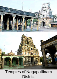
Tourism of Nagapattinam District
The district of Nagapattinam was formed in the year 1991 with it`s headquarter as Nagapattinam. Its long stretch of beach runs along the Bay of Bengal boasts of having one of the most thriving harbours of India. It has Shri Kayahorana Swami Neelayathatchi Amman Temple, Sowriraja Perumal Temple, and Nellukkadai Mariamman Temple. The mini museum, the towering lighthouse and the long beautiful beach are some of the worth visiting places in the district of Nagapattinam.
Having a long coastline, this district possesses a booming harbour in India. With the presence of long and beautiful beaches, church, dargah, etc, this district forms a most favourable destination in the state of Tamil Nadu.


