Introduction
 Kolhapur district is the southernmost district of Maharashtra. Its headquarters is at Kolhapur which is an ancient city. Kolhapur is the seat of Goddess Mahalaxmi and is one of the Shaktipeeths of India. Kolhapur was ruled by Silaharas, Yadavas, Rashtrakuta dynasty and Chalukya dynasty in the medieval times. The growth of the district in modern times is fascinating. Chhatrapati Shahu Maharaja is the architect and the founder of modern Kolhapur. The district is abundant in natural resources- water, soil, natural vegetation, animal wealth and minerals. As a result, Kolhapur is one of the most agriculturally advanced districts of not only Maharashtra but also India. It is fast becoming an industrialised district as well and is already a front runner in agro-based industries. Kolhapur district is one of the shining examples in the Co-operative Movement of India. The district has the highest per capita income in the Maharashtra State and one of the highest in the country. Kolhapur has a distinct culture developed as a result of a rich history and its quality of people who have been front-runners in various fields.
Location of Kolhapur District
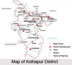
Kolhapur is a district newly formed after the merger of Kolhapur and other Indian States with the State of Bombay. It lies between 15 degrees and 17 degrees north latitude and 73 degrees and 74 degrees east longitude. It consists of 956 villages of the former Kolhapur State, five villages of the former Kurundwad State, one village of the former Miraj Senior State and seven villages that were formerly in the Belgaum district. It has an area of 3,188.4 square miles. It is bounded on the north by the district of Satara; on the west by the district of Ratnagiri and on the south and the east by the Belgaum district of Mysore State. For administrative purposes the district is divided into two parts, Northern and Southern.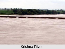
History of Kolhapur District
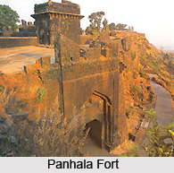
Kolhapur is famous from pre-historical times. Since 5000 years Kolhapur, has had trade relations with Rome and other countries. Evidences of the same can be seen in the Town Hall Museum. In the early 10th century, Kolhapur was the capital of the Shilahar dynasty. Many inscriptions are found in and around Kolhapur to provide evidence of the great kingdoms of the Kolhapur region. During the 11th century, Raja Bhoj the 1st built many forts in this region. The great king Chatrapati Shivaji extended his kingdom in the Konkan and Sanhyadri. Kolhapur region, lying on the boundary of Konkan and the other part of Maratha kingdom, Shivaji concentrated on this region. Forts like Panhala fort, Vishalgad, Bhudargad, Rangana, Shivgad, Gagangad etc. were specially constructed during Shivaji`s reign. Kolhapur continued to be the headquarters of many activities during the rule of the Marathas. In November 1710, Tarabai established a separate court at Panhala and declared it as a capital. During this period, Kolhapur saw many ups and downs. Kolhapur flourished in all the sectors such as art and crafts, sports, culture etc. under Chatrapati. Shahu Maharaj. In fact he is known as the architect of modern Kolhapur. His keen interests in development of agriculture and industry can even be seen in today`s era.
Geography of Kolhapur District
To a great extent, the landscape of the district of Kolhapur is influenced by the Deccan trap. Geographically, the district can be divided into three regions. This includes the Sahyadrian watershed region, the residual hill ranges and the river valleys. 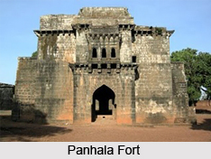 The district, on the whole, is a part of the Deccan table-land with an average height of 1800 ft. above sea level, with the Sahyadrian Scarp forming the most prominent feature along its western administrative boundary. The climate of Kolhapur is temperate. In the western part of Kolhapur near the Sahyadris it is always cooler than that in the eastern part which is liable to hot winds during April and May. The nights over the whole district are generally cool due to the influence of the sea breezes which set in during the afternoons and continue till late in the evening.
 Geography of Kolhapur district is influenced by a great extent by the Deccan traps. Only in the southern extremities the rocks of the Dharwar and Lower Kaladgi series introduce a change in the topography. The district, on the whole, is a part of the Deccan table-land with an average height of 1800 ft. above sea level, with the Sahyadrian Scarp forming the most prominent feature along its western administrative boundary. Geographically, the district can be divided into three regions.
Sahyadrian Watershed Region
In the west lies the Sahyadrian watershed-a region about 10 to 15 miles wide and running throughout the length of the Sahyadris lying in this district from the Malkapur tract in the north to Samangad in the south. The very edge of this long belt consists of the precipitous scarps of the Sahyadries that is marked by occasional terraces, steep basaltic walls and magnificent amphitheatres through which the monsoonal waters of innumerable streams are drained away to the Arabian Sea. This scarp acts both as a natural and administrative division boundary to the newly formed district of Kolhapur. This region of the Sahyadrian water-shed is thinly populated, people living in small hamlets and depending for their livelihood partly on agriculture but mostly on forest occupations. Quite a large area is under forest cover and is exploited under Governmental supervision. Human attention naturally is directed along the upper tracts of the main valleys, as for example, along the valley leading to the Ambaghat, the Kumbhi valley, the Bhoga-wati and the Vedaganga. East of this Sahyadrian watershed the landscape consists of two striking contrasts, the residual hill ranges separated by the intermediate valleys.
The residual hill ranges
From the Sahyadrian watershed several hill ranges run to the east and are separated by intermediate valleys. These are developed on the Deccan lavas and form erosional remnants having a characteristic landscape summit plateaus with rounded peaks above and structural benches below. The Panhala-Alta range is the northernmost one of the district. On the whole this is a thinly populated region. Panhala fort (3,127 ft.) is a famous historical fort and a good hill station. Pavangad is yet another fort in the vicinity. Villages on the plateau are few but at the junction of the hills and the valleys below a string of hamlets has made its appearance as for example, Pishvi, Borivade, Padali on the north and Kotoli, Porle, Nagaon and Alta in the south. The other hill ranges too participate in this general regional characteristic of the Panhala range. In all these ranges the monsoonal forest cover is gradually replaced towards the east by grasslands. Population is thin and is settled at selected localities. The typical Deccan lava topography is a characteristic feature of all these ranges.
River Valleys
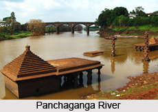 A succession of river valleys draining the land towards the east characterises the landscape of the district from the Varna valley in the north to the upper tributaries of the Ghatprabha in the south. From the human point of view these are the most important areas of the district. Well cultivated and densely peopled, Malkapur, Kasba, Sarud and Kodoli are more important villages of the Varna valley. East of Prayag which marks the confluence of the Kasari and Bhogawati lies the Panchaganga river valley proper. This is a region of rich agriculture and population. A substantial area is utilized for sugarcane. East of Kolhapur several commercially important crops are raised. Sugarcane continues to dominate the banks of the river. A little in the interior it is succeeded by tobacco, cotton, millets and wheat. Betel leaves flourish wherever well irrigation is possible. Pulses and spice crops play an important secondary role. Large sized nucleated village are typical of this region. Hatkanangale, Shirol and Ichalkaranji are local markets and taluka towns. As compared with the northern valleys the valley of the Dudhaganga River is wider and also correspondingly well-developed. Its upper regions are partly wooded and partly rice-growing areas. Towards Kagal cultivation of millets and several other crops increases. The agricultural development of this valley is well reflected in the numerous large sized villages like Valve, Solankur and Kagal.
The climate of the Kolhapur Plain is temperate and similar to the other districts of the Mumbai Deccan adjoining the ghats. In the western part of Kolhapur near the Sahyadris it is always cooler than that in the eastern part which is liable to hot winds during April and May. The nights over the whole district are generally cool due to the influence of the sea breezes which set in during the afternoons and continue till late in the evening. The year in respect of Kolhapur district may be divided into three periods as follows:-hot weather period from March to May; rainy period from June to October; and cold weather period from November to February. April is the hottest month of the year whereas December and January are the coolest. The average annual rainfall in the district varies widely from about 20 inches in the Kurundwad-Shirol area in the north-east to over 240 inches in Gaganbavada area near Sahyadri in the west.
Tourism in Kolhapur District
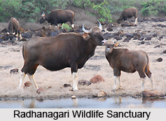
Kolhapur district has a number of attractive tourist spots to offer its visitors. Jungles, waterfalls, religious destinations, dams, hills, forts, etc. are scattered everywhere in the district. The plateau region lies along the eastern side in the basin of the Krishna River. This region of the district contains many religious tourist destinations such as Narsobawadi, Bahubali, Ranling etc. The western side of the districts is occupied by the Western Ghats mountain range. There are many forts situated here along the Sahyadri hills, such as the Panhala, Vishalgad, Shivgad, Bhudargad, Rangna, etc. The Radhanagari Wildlife Sanctuary has many species of plants and animals.
 Tourism in Kolhapur, situated on the border of Konkan, has much to offer the tourists. Jungles, waterfalls, religious destinations, dams, hills, forts, etc. are scattered everywhere in the district. On the eastern side there is the plateau in the region of the basin of the Krishna River. The soil here is highly productive. This region of the district contains many religious tourist destinations such as Narsobawadi, Bahubali, Ranling etc.
Shree Mahalaxmi, the goddess, symbolises power and prosperity. Shree Mahalaxmi is one of the prime Shaktipeeths in India, the seat of power. The devotees flock from all over India to have darshan of this deity. It is also known as Dakshin Kashi (Southern Kashi). The huge carved pillars, foliated arches in wood and graceful sculptures mesmerize the visitors.
Jotiba temple is situated 15 kms to the north of Kolhapur on the green mountains with black precipices. On Chaitra Purnima a big fair is held, when lacs of devotees flock to the temple with tall Sasan sticks and Gulal. Narsinha Saraswati Swami`s Temple is situated on the confluence of the Krishna and Panchaganga River, to the south of Shirol. Swami Narsinh was one of the 16 descents of Lord Datta.
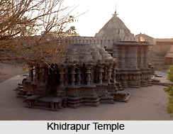
 Khidrapur, situated 65 km towards the south east of Kolhapur in Shirol tahasil is famous for the temple of Kopeshwar. The Khidrapur temple is an ancient and artistic temple, a unique example of the ancient Hemadpanthi sculpture and architecture. There are different destinations like Kumbhoj, Kaneri, Pandavdara caves, Katyayani etc. for the devotees of all castes and sects.
On the western side, the region is mainly occupied by the world famous Western Ghats mountain range. The famous Sahyadri hills carry many forts. Some of them are Panhala fort, Vishalgad, Shivgad, Bhudargad, Rangna, etc. The Western Ghats are occupied by rain forests. A variety of flora and fauna can be seen here. Rare species of plants and endangered species of animals are present here in their natural habitat. Indian Gaur is mainly seen in the region of Radhanagari Wildlife Sanctuary. Many rare birds and their endemic species can be easily seen in this region.
Administration of Kolhapur District
 Administration of Kolhapur district is carried out by the district collector. Rearrangement of the boundaries of various talukas and mahals was effected in 1949 and 1950 and Chandgad taluka from the Belgaum district was included in this district with effect from 1st October, 1956. The district now covers an area of 3184.44 square. It is divided into two prants, comprising 9 talukas and 3 mahals. The Collector is the pivot on which the district administration turns. Not only is he at the head of the Revenue Department in the district, but, in so far as the needs and exigencies of the district administration are concerned, he is expected to superintend the working of the offices of other departments. Broadly speaking, the various functions of the district collector include matters relating to Revenue, Inams, Public Utility, Accounts, Quasi-judicial functions in revenue matters, Local Self-Government, Officers of Other Departments, As District Magistrate, As District Registrar, Sanitation and Public Health, District Development Board and District Soldiers`, Sailors` and Airmen`s Board.
Collector`s Office
The Collector`s Office at Kolhapur is divided into many branches, each of which is usually in charge of a person in the grade of Mamlatdar. The Home Branch deals with all magisterial work, the administration of the Bombay Entertainments Duty Act (I of 1923), the Arms Act (XI of 1878), and political work connected with the maintenance of law and order. The English Branch deals with the District Local Board, municipalities and village panchayats, passports, political work, prohibition and excise, public works, petroleum, medical affairs, fairs, Backward Class Board meetings, etc. The Chitnis Branch deals with matters like land revenue, land grants, watans, cash allowances, tagai, establishment, encroachments, dues of co-operative societies, tenancy, execution of decrees of civil courts (darkhast), audit of village accounts (jamabandi audit), and inspection of talukas and public offices. The District Registration Office is one of the branches and is in charge of the Headquarter Sub-Registrar. The Treasury Branch is in charge of the Treasury Officer. There are separate branches dealing the Court of Wards, the District Soldiers`, Sailors` and Airmen`s Board and the District Development Board. There are branches dealing with Elections, Refugees and Evacuees, but these are purely temporary.
Prant Officers
Under the Collector are the Prant Officers who are either Assistant Collectors (Indian Administrative Service Officers) or District Deputy Collectors. The two Prants in the District have each a separate Prant Officer in charge. The Prant Officer in charge of Kolhapur or Northern Division has his head-quarters at Kolhapur. The Prant Officers form the connecting link between the Mamlatdar and the Collector. A Prant Officer exercises all the powers conferred on the Collector by the Land Revenue Code and by any other law in force or by executive orders, in regard to the talukas and mahals in his charge, except such powers as the Collector may specially reserve to himself. His main functions deal with revenue matters, magisterial matters and other duties.
Mamlatdars and Mahalkaris
The Mamlatdar is the officer in executive charge of a taluka and the Mahalkari has the executive charge of a mahal. There is a sub-treasury in every taluka or mahal, and there is practically no difference of kind between the functions and duties of a Mamlatdar and those of a Mahalkari. Each taluka or mahal has on the average two or three head clerks (or aval karkuns), 15 or 18 clerks, 60 talathis, two Circle Officers and two Circle Inspectors. The duties of Mamlatdars and Mahalkaris fall under various heads. Functions here deal with revenue, Quasi-judicial functions, magisterial matters, treasury and accounts and other administrative duties.
Circle Officers and Circle Inspectors
In order to assist the Mamlatdar in exercising proper supervision over the village officers and village servants and to make local enquiries of every kind promptly, Circle Officer in the grade of Aval Karkuns and Circle Inspectors in the grade of Karkuns are appointed. The Circle Officer certifies entries in the record of rights, and thus relieves the Mamlatdar of a good deal of routine work. There are from 30 to 50 villages in charge of a Circle Officer or Circle Inspector. These officers form a link between the Mamlatdar and the village officers. There are generally two Circle Officers and one Circle Inspector in each taluka.
Patil
The Patil is the principal official in a village. The duties of the Patil mainly deal with revenue, quasi-magisterial and administrative matters.
Talathi
The office of village accountant used generally to be held by hereditary kulkarnis. With effect from 1st May 1951, all kulkarni watans along with the right of service were abolished by the Bombay Pargana and Kulkarni Watans Abolition Act (LX of 1950). If the villages are small one talathi is appointed for two or more villages, which are called his charge or saza.
Village Servants
In addition to the village officers mentioned above, there are some hereditary village servants. They are of two kinds (i) those useful to Government, and (ii) those useful to the community. The village servants useful to Government are the Mahars and the Ramosh`s (Ramosis). They are remunerated by watans, which take the form of grants of land either entirely free of assessment or subject to an annual reduced assessment (called mamul judi) or cash payment from the Government treasury, or both. The Mahars help the village patil and the talathi in the collection of revenue and do all duties in connection with village administration. The village servants useful to the community are known as balutedars. Under the baluta system, the balutedars have certain rights and privileges at ceremonies, etc. Their services are remunerated by the cultivators in the shape of an annual payment in sheaves of corn and a few seers of other grain grown in the field, such as wheat, hulga, gram, tur, groundnut, etc.
This is the administrative layout of the district of Kolhapur from the level of the district collector right down to the grassroots level.


