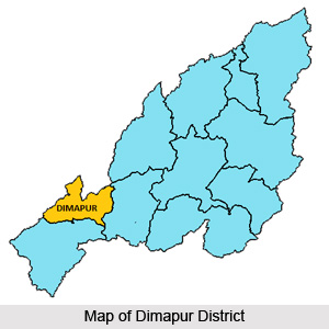
 Dimapur District was inaugurated as the eighth district of Nagaland in December, 1997, with its headquarters located at Dimapur. Earlier it was a sub-division under Kohima District. Besides being referred to as a gateway of Nagaland and Manipur, main commercial activities of the state, is centered on Dimapur. Dimapur District is bounded by Kohima District on the south and east, Karbi Anglong District of Assam on the west, Karbi Anglong and Golaghat District of Assam, in the west and in the north. Dimapur city, the district headquarter is distinct in its character where all the different communities have congregated, portraying a mini India.
History of Dimapur District
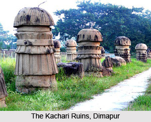
Dimapur is the ancient capital of Kachari tribe, who ruled till 13th century AD. Reminiscences of the glory of this kingdom can be found in the ruins that are scattered in and around the town. These ruins give evidence of a culture that were predominantly Non-Aryans. Dimapur District draws its name from the Kachari dialect; `di` - meaning river, `ma` - meaning great or big, and `pur` - meaning city, together connoting `the city near the great river`. Kachari kingdom flourished in Dimapur is evident from the existence of Kachari Rajbari Fort ruins, housing the ancient stone monoliths, and the many excavated tanks.
 Geography of Dimapur District
A large area of Dimapur District is in the plains with an average elevation of 260 metres above the sea level. Dimapur is situated at 25 degree 54 minutes 45 seconds north Latitude and 93 degree 44 minutes 30 seconds east longitude. Climate is hot and humid in the plains of Dimapur District during summer (reaching a maximum of 36 degree Celsius, with humidity up to 93 percent) while the winter months are cool and pleasant. The average annual rainfall in the district is around 1504.7 mm.
Administration of Dimapur District
Administration of Dimapur District is headed by a deputy commissioner. This district has four sub-divisions; Nuiland and Medziphima with Additional Deputy Commissioner as the administrative head and Kuhuboto and Dhansririphar sub-divisions headed by Sub-divisional Officer.
Tourism in Dimapur District
Tourism in Dimapur District means exploring the scenic beauty of the place through its waterfalls and parks. Some of the major tourist attractions of Dimapur District include Zoological Park, Diezephe Craft Village, Green Park, Kachari Ruins, Triple Fall, Shiv Mandir and Science Park. Tourism in Dimapur District offers a tranquil and memorable experience for the visitors coming from various parts of the country.
The only railhead and airport of the state is located in Dimapur, the district headquarters.


