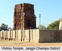
 Janjgir-Champa District of Chhattisgarh came into existence on 25th of May, 1998. This district is situated in the central region of the state and so it is considered as the `Heart of Chhattisgarh`. District headquarters of Janjgir-Champa District are at Janjgir, which is popularly known as the city of Maharaja Jajawalya Dev of Kulchury dynasty. Janjgir-Champa District is a major producer of food grains in Chhattisgarh. Janjgir is 65 kms away from Bilaspur and 175 kms from state capital Raipur. Vishnu Mandir of this district reflects the golden past of this district. Vishnu Mandir of Janjgir-Champa District is an ancient artistic sample of Vaishnava community. Further, the Hasdeobango project has been considered as life supporting canal for the district. Under this project three-fourth of the total area of the district will be covered for irrigation. As per Census 2001 the total population of Janjgir-Champa District is 1,317,431.
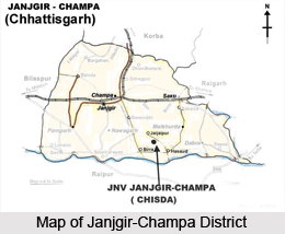
 Location of Janjgir-Champa District
Janjgir-Champa District is located between the longitudes 21.6 degree to 22.4 degree towards the north and latitude 82.3 degree to 83.2 degree towards east. The altitude of this district is 294.4 metres above the sea level. Janjgir-Champa District is bounded by Raigarh District in its east, by Bilaspur District in its west, by Korba in its north and by Mahanadi River, Raigarh District in its south. Total area of Janjgir-Champa District is 4,46,674 sq kms.
Administration of Janjgir-Champa District
Administration of Janjgir-Champa District includes five sub-divisions and these are Janjgir, Pamgarh, Champa, Sakti and Dabhara. The 10 tehsils of this district are Janjgir, Akaltara, Baloda, Nawagarh, Champa, Pamgarh, Sakti, Jaijaipur, Malkharoda and Dabhara. There are around 913 revenue villages under the administrative set-up of Janjgir-Champa District.
Tourism in Janjgir-Champa District
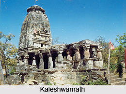 There are several tourist attractions in Janjgir-Champa District. One can experience nature as well as pilgrimage tourism during a visit to this district of Chhattisgarh. Some of the major tourist attractions of this place are Vishnu Mandir, Madanpurgarh, Rishabhtirth, Shivarinarayan, Kaleshwarnath (Pithampur), Chandrahasini (Chandrapur), Ashtabhuji (Adhbhar), Laxmenshwar (Kharod) and more.
Janjgir-Champa District has a huge portion of its total area covered by forests. Major forest produce are Tendu Patta, Salseed, Harra, Mahua and Sagon. Several crops are cultivated in this region like paddy, wheat, etc. The main industries of this district include Iron, Cement and Paper industries. This district also has several educational institutions and healthcare facilities.


