 Satara district is located in the western part of Maharashtra. It lies between the north latitudes of 17.5 and 18.11 and east longitude of 73.33 and 74.54. It is bounded by the district of Pune in the North, Solapur district in the east, Sangli district in the south and Ratnagiri district in the west. Raigad district lies to its north-west. Satara district is situated in the river basins of the Bhima River and the Krishna River. The physical settings of Satara shows a contrast of immense dimensions and reveals a variety of landscapes influenced by relief, climate and vegetation. The variation in relief ranges from the pinnacles and high plateaus of the main Sahyadari range having a height over 4500 feet above mean sea level to the subdued basin of the Nira river in Phaltan tahasil, with an average height of about 1700 feet above mean sea level.
The climate ranges from the rainiest in the Mahabaleshwar region, which has an average annual all of over 6000 mm to the driest in Man tahsil where the average annual rainfall is about 500 mm. The average rainfall in the district is around 1426 mm. The minimum temperature in the district hovers around 11.6 degree Celsius whereas the maximum temperature reaches around 37.5 degree Celsius. The vegetation cover also varies from the typical monsoon forest in the western parts to scrub and poor grass in the eastern parts. The district covers a total geographical area of 10484 Sq.Kms.
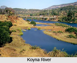
The main rivers of Satara district are the Koyna River and the Krishna River. The Krishna is one of the three largest sacred rivers of southern India. Approximately 172 kms of the river course falls inside the district. The Krishna River begins on the eastern brow of the Mahabaleshwar plateau and the source is about 4500 ft. above sea level. Kudali, Urmodi, Venna and Tarali are small feeder rivers of Krishna. Koyna is the largest tributary of the Krishna in the district. Neera and Manganga rivers are the two tributaries of the Bhima in the north and north eastern parts of the district. There are 10 Major , 13 Medium and 80 minor irrigation projects ( total - 103 ) which are in progress undertaken by the Krishna Valley Development Corporation. Among the major crops grown in the district are bajra, jowar, wheat, rice, ghewada, gram, sugarcane, groundnut, potato and soyabean. Sugarcane is the annual crop of the district.


