Introduction
 Chandrapur district was the largest district in all of India before it was split into the two separate districts of Gadchiroli and Chandrapur. It is currently a part of the Napur division of the state of Maharashtra. The district is famous for its super thermal power plant which is one of the biggest in Asia and it has vast coal reserves. It is one of the largest reservoirs of limestone and therefore there are a lot of cement factories like Larsen and Tubro (now Ultratech) Gujarat Ambuja (Maratha Cement Works), Manikgard and ACC. The district covers a total area of 11,443 Sq. Kms which constitutes 3.72 percent of the total area of the state. Among the major languages spoken in the district are the Marathi language, Gondi language, Kolam and Hindi language. Further details about the district are furnished below.
History of Chandrapur District
In the past Hindu and Buddhist kings ruled the area for a long time. In 1854, Chandrapur formed an independent district and in 1874 it comprised the three tehsils Mul, Warora and Bramhpuri. A new tehsil with headquarter at Gadchiroli was created in 1905 by the transfer of zamindari estates from Bramhpuri and Chandrapur tehsil. In 1907 a small zamindari tract from Chandrapur district was transferred to the newly formed districts. After India`s independence in 1947, the former Central Provinces became the new Indian state of Madhya Pradesh. No major changes occurred in the boundaries of the district or its tehsils between 1911-1955. In 1956, during the linguistic re-organisation of states, the Marathi-speaking district of Chandrapur was transferred from Madhya Pradesh to become part of Bombay State. Rajura tehsil, a part of Adilabad district of Hyderabad state, was transferred to Nanded district subsequently it was transferred to Chandrapur district in 1959. The district became part of Maharashtra since its creation in May 1960. In order to lessen the administrative burden in 1981 this district was again divided into Chandrapur and Gadchiroli. Chandrapur district now comprises the tehsil of Chandrapur, Bhadravati, Warora, Chimur, Nagbhir, Bramhpuri, Sindhewahi, Mul, Gondpipri, Pomburna, Saoli, Rajura, Korpana, Jivati and Balharshah.
 History of Chandrapur district has traced a long path. The district of Chandrapur was earlier known as `Chanda`. According to tradition and legend the name of the place was `Lokapura` which was first changed to ` Indpur` and subsequently to Chandrapur. During the British colonial period it was called Chanda district, which was again changed to its original name `Chandrapur ` around 1964. Other places of the region in ancient times include Wairangad, Kosala, Bhadravati and Markanda. Hindu and Buddhist kings are said to have ruled the area for a long time. Later on Gonds overtook the Dana Chiefs who ruled Chandrapur around the 9th century. The Gond Kings went on to rule the area till 1751 following which the Maratha period started. Raghuji Bhosale, the last king of the dynasty, died heirless in 1853 and Nagpur province, together with Chandrapur, was declared annexed to the British Empire.
In 1854, Chandrapur formed an independent district and in 1874, it comprised of three tehsils viz. Mul, Warora and Bramhpuri. In 1874, however, the upper Godavari district of Madras was abolished and four tehsils were added to Chandrapur to form one tehsil with Sironcha as its headquarters. A new tehsil with headquarter at Gadchiroli was created in 1905 by the transfer of zamindari estates from Bramhpuri and Chandrapur tehsil. A small zamindari tract from Chandrapur district was transferred to the newly formed districts in 1907. In the same year an area of about 1560 sq. km. comprising of three divisions of the lower Sironcha tehsil namely Cherla, Albak and Nugir were transferred to Chennai State.
No major changes occurred in the boundaries of the district or its tehsils between 1911-1955. Consequent upon reorganization of the states in 1956, the district was transferred from Madhya Pradesh to the Mumbai state. In the same Rajura tehsil, a part of Adilabad district of Hyderabad state, was transferred to the Nanded district and subsequently it was transferred to Chandrapur district in 1959. The district became part of Maharashtra since its creation in May 1960. For administrative convenience and industrial and agricultural development, this district was again divided into Chandrapur and Gadchiroli district after 1981 census. Chandrapur district now comprises of the tehsil of Chandrapur, Bhadravati, Warora, Chimur, Nagbhir, Bramhpuri, Sindhewahi, Mul, Gondpipri, Pomburna, Saoli, Rajura, Korpana, Jivati and Balharshah.
Geography of Chandrapur District
The climate of the district can be classified as tropical hot climate with high temperatures throughout the year. The two prominent seasons of the district are the very hot summer and moderate winter. Winter season is short and mild while the summers are hot and prolonged. After the summer, comes the monsoon, which lasts till late September. 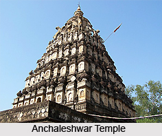 There is no drought prone area in the district as the southwest monsoon brings a lot of rainfall. The average annual rainfall is about 1420 mm. The eastern part receives more rainfall than the west. Average no of rainy days is 60 to 65 through out the district. The humidity level in the district is very high during the monsoons, which fall down during the summer season. The temperature starts decreasing from the month of October. December is the coldest month. During the summer season the temperature rises as high as 46 degree Celsius, and the district is amongst the highest temperature in the South Asian region. Usually the wind blows from south to north. In summer the wind blows from east to and south and during the monsoon from south to east. During winter, the wind direction changes from north to east. The region is a part of the Godavari basin. The three tributaries of the Godavari flow in this region. They are the Wardha, the Wainganga and the Penganga rivers. The main river of the district is the Wainganga River, which flows along the border of Chandrapur and Gadchiroli district. The Wardha is the only perennial river in the district. The Penganga River that flows along the western border takes east west course and then joins the Wardha River at Wadha near Ghugus.
 Geography of Chandrapur District is determined by its location in the state of Maharashtra. Physiographic ally, the district is situated in the Wainganga and Wardha river basin. The eastern and western boundaries of the district are well defined by the Waingabga River and Wardha, the tributaries of the Godavari River. The district is located along the eastern edge of the state, between the latitudes of 19.30 degree North to 20.45 degree North and the longitude of 78.46 degree East. Chandrapur district occupies an area of 11,443 sq. Kms which constitutes 3.72 percent of the total area of the state.
Topography of Chandrapur district can be divided into two parts on the basis of district physiographic features.
1. The plain and the fertile region lying in the river valleys of the Wardha river , the Penganga river and the Wainganga river:
The widely spread and flat terrain exhibits mostly rolling topography with residual knolls of the hills in the southern portion while in the northern portion, that is in the Brahmapuri tahsil, fairly wide flood and alluvial plains covered with fertile loams are observed. The flat terrain of Chandrapur district on the whole lies generally between 250 m above sea level. In the Penganga valley, flat terrain covers very little area in the south western portion of the district. The area occupied by the Penganga basin in the south-western parts of the district in Rajura and Chandur tahsils exhibits mostly hilly topography. The hills are known as Gadchandur and Manikgarh hills, and the altitude in general rises to 500m above mean sea level.
2. The upland hilly region:
The upland hilly region lies between the Wardha and the Wainganga rivers comprising parts of Warora, Chandrapur and mojor part of Brahmapuri tahsils. It has sandy soil. The mills in Wardha, Brahmapuri and Brahmapuri district are low altitude hills called `Chimur-Perjagarh-Mul hills`. The altitude of these hills is on average 300 m. above mean sea level.
 As a result of the geographical location and physical features, the climate of the district can be classified as tropical hot climate with a high range of temperature throughout year.
There are two main seasons in the district- very hot summer and moderate winter. The summer months are very hot and prolonged while winter is short and mild. The monsoon season commences immediately after summer and continues till late September. A lot of rainfall is brought by the south-west monsoons and there is no drought-prone area in the district. The temperature starts decreasing from the month of October. December is the coldest month when mean maximum temperature is around 28.2 degree Celsius, and mean minimum is 11.6 degree Celsius. The daily mean temperature starts rising from the month of February and may is the peak summer month when mean maximum temperature goes up to 43 degree Celsius and minimum temperature is 28 degree Celsius to 29 degree Celsius. In severe heat condition temperature rises up to 46 degree Celsius. The average annual rainfall is about 1420 mm. The eastern part receives more rainfall than the west. Average no of rainy days is between 60 to 65 throughout the district. The relative humidity is very high during monsoon season, when it exceeds 70 percent, but after monsoon season it falls down rapidly and in summer it is only 20 percent. The prominent wind direction is from south to north. In summer the wind direction is from east to and south and monsoon from south to east. During winter, the wind direction changes from north to east.
As a result of the geographical location and physical features, the climate of the district can be classified as tropical hot climate with a high range of temperature throughout year.
There are two main seasons in the district- very hot summer and moderate winter. The summer months are very hot and prolonged while winter is short and mild. The monsoon season commences immediately after summer and continues till late September. A lot of rainfall is brought by the south-west monsoons and there is no drought-prone area in the district. The temperature starts decreasing from the month of October. December is the coldest month when mean maximum temperature is around 28.2 degree Celsius, and mean minimum is 11.6 degree Celsius. The daily mean temperature starts rising from the month of February and may is the peak summer month when mean maximum temperature goes up to 43 degree Celsius and minimum temperature is 28 degree Celsius to 29 degree Celsius. In severe heat condition temperature rises up to 46 degree Celsius. The average annual rainfall is about 1420 mm. The eastern part receives more rainfall than the west. Average no of rainy days is between 60 to 65 throughout the district. The relative humidity is very high during monsoon season, when it exceeds 70 percent, but after monsoon season it falls down rapidly and in summer it is only 20 percent. The prominent wind direction is from south to north. In summer the wind direction is from east to and south and monsoon from south to east. During winter, the wind direction changes from north to east.
The soils of Chandrapur district are of various types. Each type covers a well-defined tract which displays cropping pattern of totally different level. The soils occurring in the Wardha and the Wainganga valleys are generally most fertile. The soil of the district is well defined and conductive for growing crops of various kinds. The most fertile soils are found in the Wardha district and Wainganga valleys. The soil conditions along Wardha-Painganga valleys are rich with black regur loams and clay loams along the river bed. These soils locally known as kali soils are very productive and suitable for rabi crops due to high moisture retention capacity. However water logging is very common during monsoon and it is therefore not suitable for kharif crops.
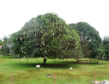
The vegetation of the district is characterized as southern Tropical Dry Deciduous Forest where teak is the dominant species. Other associated species are ain, bamboo, bijja, dhada, haldu, semal, tendu etc. depending upon the physiographic features. Jamun tree, Mango tree and Arjun tree are found in moist areas. The slopes of the hills have poor and low density vegetation. The plains of the tract have luxuriant forest.
Location of Chandrapur District
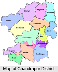
Chandrapur district is located in the eastern edge of Maharashtra in Nagpur division and forms the eastern part of `Vidharbha` region. It is located between the latitudes of 19.30 degrees north and 20.45 degrees north, and 78.46 degrees east longitude. It is the easternmost district of the state of Maharashtra. The district is bounded by Nagpur, Bhandara and Wardha on the northern side, Yavatmal district on the western side, Gadchiroli on the eastern side and Adilibad district of Andhra Pradesh on the southern side. Physiographically, the district is situated in the Wainganga and Wardha river basin. The eastern and western boundaries of the district are well defined by the river Waingabga river and the Wardha, the tributaries of Godavari river. Chandrapur district occupies an area of 11,443 sq. Km. which constitutes 3.72 percent of the total area of the state.
Education in Chandrapur District
In Chandrapur district, a large variety of educational facilities exists to cater to the needs of a population of 17.71 lakh (as per the Census of 2001). In 2001, there were 2246 primary schools, 422 middle schools, 212 secondary schools, 37 higher secondary/PUC/intermediate schools, 29 colleges, 77 adult literacy centres and 49 vocational training institutions. They are distributed all over the district while higher order facilities like colleges, vocational training institutions etc, are mostly found in towns, the primary schools, middle schools, adult literacy centres etc predominate in the villages.
Tourism in Chandrapur District
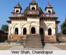
There are a number of ancient temples located in Chandrapur, such as the temples of Ankleshwar (Lord Shiva) and Mahakali (Goddess Mahakali). 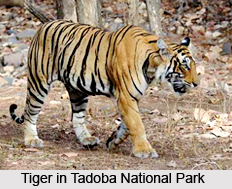 Tadoba National Park near Chandrapur is one of India`s 28 Project tiger reserves and one of the famous tourist spots in all of Maharashtra. Other tourist places are Ramala Tank, Junona Tank at Chandrapur, Ghodazari Project, Satbahini Tapovan at Naghbir, Adyal Tekari at Bramhpuri, Ramdegi at Chimur.
Tourism in Chandrapur district is a relaxing experience. There are many places located here where one can go in to soak in the atmosphere and to relax in the calm and beauty of the place. One of the most famous tourist attractions located in the district, which in fact is a major tourism site in all of Maharashtra, is the Tadoba - Andhari Tiger Reserve. Apart from the tigers, there is a great variety of animal species found here such as Nilgai, sloth bear, chital, sambar etc. Another major tourist attraction in the district, especially among foreign tourists is the Anandwan Ashram at Warora. 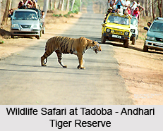 It is the Ashram of the renowned social worker Baba Amte, who has done much for the care of leprosy patients. There are many other tourist spots located in the district of Chandrapur which are discussed below:
Pilgrimage Tourism in Chandrapur District
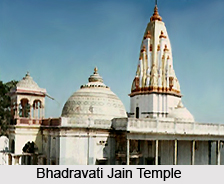
Bhadravati Jain Temple
This temple in the town is very popular with the Jain community. It has very beautiful sculptures. This temple is located as Bhadravati village, 32 kilometres from Chandrapur town on Central Railways. This temple is said to be extremely old, but the exact time of its construction is not known. There are several other idols in the temples, which were recovered in digging the earth.
Ganesh Temple
This is also an ancient temple of Lord Ganesha and is visited by a large number of devotees throughout the year. The temple architecture and sculptures are a major tourist attraction.
Vijasan Hills
There are several temples here which are very attractive. The atmosphere here is very serene and calm and one can come here to soak in the religious significance of the place as well as to relax in the serenity of the environment.
Nature Tourism in Chandrapur district
Tadoba - Andhari Tiger Reserve (TATR)
 It represents a unique habitat for wildlife in Central India. Tadoba Andhari Tiger Reserve comprises of the Tadoba National Park and Andhari wildlife Sanctuary. The National park derives its name from the local tribal god "Taru" whereas the Andhari River flowing through the forests gives the sanctuary its name. The forests mainly consist of teak and bamboo interspersed with grassy meadows while Tadoba is a rugged hilly terrain. The area has a wide and rich range of flora and fauna. Teak and bamboo trees dominate southern deciduous forests. There is vast diversity in fauna and various types of species are found here. The major attraction in this place is the presence of tigers. The large herds of Chital and the stately Sambar are often seen in the forest. Other attractions include the barking deer, the chausinga, the gaur, nilgai, sloth bear, wild dogs, wild boar, leopard etc. As night falls the small Indian civet, palm civet, the rattle and flying squirrel make their presence felt. In the backdrop of the famous Ram degi Temple, nature is as its best at Tadoba.
Leisure Tourism in Chandrapur District
Ghora Jhari Development Scheme
This lake is situated in Nagbhir tehsil. It is 6 kms away from the main Nagpur - Chandrapur highway, 106 kms from Chandrapur town and 97 kms from Nagpur. The capacity of the reservoir is 45 cusecs of water.
Junona Development Scheme
This spot is 15 kms away from the town of Chandrapur. Here, there are well developed facilities for boating, and there are also restaurants and parks located here.
Anandwan Ashram at Warora
Warora town has come into prominence due to the location of the `Anandvan Ashram`. It is the ashram of the well-known social worker and Maharashtrabhushan Shri Baba Amte whose services and efforts for the rehabilitation and care of leprosy patients have earned him worldwide recognition. Foreign tourists in large numbers often visit the Anandvan Ashram.
Thus mentioned are the various tourist attractions located in the district of Chandrapur.


