Introduction
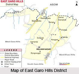 East Garo Hills District is an administrative district of Meghalaya. It was advanced from a sub-division to a separate district in 1976 after the erstwhile Garo Hills District was reorganized with a view to bring the administration closer to the people. East Garo Hills District is bounded by South Garo Hills on the south, by West Garo Hills on the west, by East Khasi Hills on the East and by Assam on the north. Williamnagar is the districts headquarters. The headquarter-complex is a neatly planned township. It has been christened as Williamnagar after the name of Captain Williamson A. Sangma, the first chief minister of Meghalaya. Williamnagar now has all the amenities of a modern town and is the largest growth centre in Garo Hills, next to Tura. East Garo Hills District occupies a total area of 2603 sq kms. This district lies between 25.24 degree north and 26.10 degree north latitude and 90 degree east and 91.3 degree east longitude.
History of East Garo Hills District
 Early history of East Garo Hills District is vague and unclear because of lack of written records prior to the coming of the British. Moreover, some of the past records suggesting the history of Garo Hills depend entirely on the indigenous legend and oral traditions, folklore and folksongs, and other circumstantial evidence of Garo tribe which are, however, most uncertain and reliable sources of information. Indigenous traditions of Garo Tribe relate that they originally came from Tibet. Later on, they crossed Brahmaputra River and advanced towards Guwahati, where they settled along the Brahmaputra valley. Eventually, Garo Kingdom was established.
History of East Garo Hills District further suggests that with the passage of time in the medieval period the Garos in the hills were divided into a number of petty Nokmaships. However, the plain tracts along the fringes at the foot of the hills were included in the many Zamindari Estates, which eventually developed into fewer but larger complexes. During the mediaeval era and the Mughal period, important estates bordering the Garo Hills were Karaibari, Kalimalupara, Mechpara and Habraghat in Rongpur district, Susang and Sherput in Mymensingh district of Bengal and Bijini in the Eastern Duars. Early records describe the Garos as being in a state of intermittent conflict with Zamindars of these large estates.
According to the modern period of the history of East Garo Hills District, contacts between the British and the Garos started after the British East India Company had secured the Diwani of Bengal from the Mughal Emperor. Consequently, all the estates bordering Garo Hills were brought under the control of the British. The Zamindars were not disturbed in the internal management of their estates. In fact, they were entrusted, as they had been by the Mughals, with the responsibility of keeping the hill Garos in check with help of their retainers. Thus in the beginning, the intermittent conflict between the Zamindars and the Garos went on unabated until the situation deteriorated further. This condition led ultimately to the annexation of the Garo Hills in the year 1873. Captain Williamson was the first Deputy Commissioner of the unified district. The district was bifurcated into two districts namely East Garo Hills and West Garo Hills in October, 1979.
Geography of East Garo Hills District
Geography of East Garo Hills District is spread over hilly terrain. The hills are highly dissected and one major formation is the Arbella Range, which cuts through the south-central part of the district. The range consists of peaks with an average height of 700 metres above sea level. Another important physiographic feature is the Simsang Valley which runs through the southern part of the district.
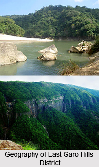 River Simsang is the longest river in Garo Hills, which originates in West Garo Hills and flows through East Garo Hills and South Garo Hills. The topography of the rest of the district is of undulating low hills, with altitude ranging from 150 to 600 metres above sea level, with plain fringes in the northern areas neighbouring Assam. Besides Simsang River, other rivers flowing through East Garo Hills District are Manda (Dudhnoi), Ildek, Didram and Damring (Krishnoi). Other than Simsang which drains south-eastwards, others run north or northwest towards the Brahmaputra River.
Demography of East Garo Hills District
As per Census 2001, total population of East Garo Hills District is 2,50,582. The population of this district consists of two major groups - tribal and non-tribal. The tribal population of the district amounts to near about 96.54 percent of the total population. The majority of the tribal populations are the Garos, while the other indigenous inhabitants are the Hajongs, Rabha Tribe, Koches, Rajbonshies, Kachari and Dalus. The small non-tribal population, including the Scheduled Castes is mostly concentrated in the urban settlements of Williamnagar and Resubelpara and the northern plain fringes of the district. The distribution of population in East Garo Hills District is uneven and is mostly governed by its topography. The population of the district is mainly concentrated on the northern fringe plain area. Since the economy of the district is primarily agricultural, the topography and soil type have a great influence on the population distribution. Also the uneven topography which also influences factors such as accessibility to the areas causes the low density of population in the interiors of the district.
People of East Garo Hills District
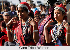
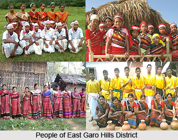
People of East Garo Hills District are mainly the Garo Tribes and when it comes to the people the social life, the language and other features are taken into account. Garos constitute the majority in the East Garo Hills district as is evident from the name of the district. The district also is home for a sizeable population of Rabha Tribes, Hajong Tribes, Koch Tribes, Dalus, Banais and Boros.
As history exemplifies the Garos are the second largest tribe after the Khasis in Meghalaya and they refer themselves as A`chik or Mande and their language converged to the Bodo language branch of the Bodo-Naga-Kachin family of Sino Tibetan phylum. This Garo populace is basically distributed over the three Garo Hills districts of Meghalaya, the Mymensingh District of Bangladesh and the Kamrup, Goalpara and Karbi-Anglong districts of Assam. They can even be seen scattered in a few numbers in Tripura and Nagaland.
As the Garos are and were scattered far and wide since time immemorial and since these scattered units were in isolation from each other over the bridges of time it is obvious that they have developed their own separate identities and dialects. Even then features like their traditional political setup, social institutions, and marriage systems, inheritance of properties, religion and beliefs are frequent between these groups. Moreover, these groups are endogamous generally. The various dialect groups that comprises the Garos are the Ambeng, Atong, Akawe (or Awe), Duals, Matchi, Matabengs, Chibok, Chisak Megam or Lyngngam, Ruga, Gara-Ganching. However the most significant and striking difference is that between the groups who live closer to the plains and the hill dwellers that constitute the remaining groups. The Garos of the hills practice slash-and-burn agriculture or Jhum-cultivation while the Garo of the plains practice wet-rice agriculture and live in a cultural and ecological environment entirely different from that of the Garo of the hills.
 Society of East Garo Hills District
One interesting feature of the Garo society is that it is entirely a casteless society which even sets the democratic parameter of the clan. It is matrilineal and inheritance is through the mother. All children, as soon as they are born, belong to their mother`s Ma`Chong, whence Dalton`s Term "motherhood". Inheritance of property among the Garos is generally linked with matrimonial relations, and although men may have no property to pass on, they have an important say in deciding to whom it should pass. The heiress is generally, the youngest daughter or the "Nokna". If the Nokna is unmarried, as she often is, since selection generally takes place before she get married, the father will try to get a young man from his own lineage, commonly the son of his own sister, as the husband of the heiress. The nokna`s husband is called the "Nokrom".
Settlement of East Garo Hills District
The Garos live in semi-permanent villages varying in size from 10 to 60 houses. Village populations rarely exceed 300. There are five named, exogamous, matrilineal prairies called "Chatchi". Only two of these, Sangma and Marak, are found throughout. The other three viz. Momin, Shira and Arengh are not widely distributed. The Phratries are divided into many named, matrilineal sibs, each of which is restricted to a specific locality. The sibs are divided into unnamed lineages referred to as Mahari. Each village is built around one or two of these lineages, and most of the lineage women, with their husbands, live in the village, as do some of the men with their wives. One household is usually considered to be the most senior, and the other houses are thought to have branched out from it. This household holds all the village land, and the husband of the heiress is considered to be the headman of the village or the Nokma.
Economy of East Garo Hills District
Historically, the Garos were hardly land owners and whatever land they hold in possession, it is without ownership documents and the land belonged to the tribe as a collective property, cultivated under a cooperative system. Theoretically, land is owned by the Nokma, and new sections are distributed among the households each year. Among the hill Garos, all subsistence is based on Jhum Cultivation. Dry rice is the primary crop, and millet is also important. In addition, bananas, papaya, maize, manioc, taro, squash, large-pod beans, sorrel, gourds, and many other vegetables are grown to supplement the diet. Important cash crops are cotton, chilli peppers, and ginger. Wet rice has been grown more recently in some of the low areas, and this has changed the land tenure system to one of individual ownership, a situation which has had profound implications for the social structure.
Sports in East Garo Hills District
There are no organized games such among the Garos, though this does not imply that they have nothing to amuse themselves with. Games are generally played occasionally. Jumping contests and other competitions are indulged in more as tests of strength. The young males, members of the Nokpantes or Bachelor`s Dormitories, may organize themselves into groups and engage in such contests as the Wa`pong Sika, the Garo version of the tug-of-war, in which a stout bamboo pole replaces the rope and the contesting teams try to push each other beyond a marked line instead of pulling. Again, the villages may turn out in strength to take part in communal fishing.
Culture of East Garo Hills District
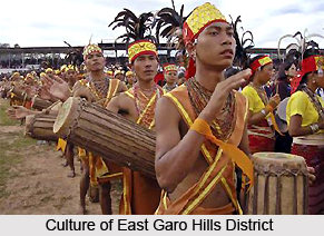 Culture of East Garo Hills District is mainly influenced by the indigenous traditions and beliefs of the tribal people. Garos comprise the majority of the population in this district of Meghalaya. Other tribal groups constituting the population of East Garo Hills District include the Rabha tribe, Hajongs, Koches, Dalus and Bodo tribe. Garos use a language that belongs to the Bodo branch of the Bodo-Naga-Kachin family. The various dialect groups that comprises the Garos are the Ambeng, Atong, Akawe (or Awe), Duals, Matchi, Matabengs, Chibok, Chisak Megam or Lyngngam, Ruga, Gara-Ganching. The Garos of the hills practice slash-and-burn agriculture or jhum-cultivation while the Garo of the plains practice wet-rice agriculture.
Garo society is principally matrilineal. Inheritance of property among the Garos is generally linked with matrimonial relations. People belonging to the Garo tribal community live in semi-permanent villages varying in size from 10 to 60 houses. Village populations rarely exceed 300. Historically, the Garos did not own land - whatever land they hold in possession, they do so without any ownership documents and the land belonged to the tribe as a collective property, cultivated under a cooperative system. Among the hill Garos, all subsistence is based on jhum cultivation. Dry rice is the primary crop, and millet is also important. In addition, bananas, papaya, maize, manioc, taro, squash, large-pod beans, sorrel, gourds, and many other vegetables are grown to supplement the diet. Important cash crops are cotton, chili peppers, and ginger.
Religious and traditional beliefs of Garo tribe heavily influence the culture of East Garo Hills District. Garos traditionally follow their own religion known as Songsarek. They also have a belief system with an underlying principle of fear and dread of the supernatural powers. Appropriate sacrifices are offered to them as occasions demand. In fact, in all religious ceremonies, sacrifices were essential for the propitiation of the spirits. The Garos also show reverence to their ancestors by offering food to the departed souls and by erection of memorial stones. Like other religions, the Songsarek religion ascribes to every human being the possession of a spirit that remains with him throughout his lifetime and leaves the body at death.
Garos normally do use many ornaments. The basic ornaments used by them are string of beads and earring (worn both by men and women). Culture of East Garo Hills District also includes festivals, celebrations, songs and dance performaces. Interestingly, there are no organized games as such among the Garos. However, games are generally played occasionally. The common and regular festivities are, of course, those connected with agricultural operations. Biggest Garo festival is `Wangala` which is more a celebration of thanksgiving after harvest. There is no fixed date for the celebration, it varies from one village to another, but usually, Wangala is celebrated in October. Preparations start well in advance. Dance performances add more charm to the entire celebration of this festival.
Festivals of East Garo Hills District
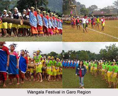
Festivals of East Garo Hills District reflect the ethno religious copious culture of the place, the festivals being Wangala and others. The Garos traditionally follow their own religion known as "Songsarek", which has roots in agriculture. They also have a belief system with an underlying principle of fear and dread of the supernatural powers, which led many scholars and researchers to wrongly think that the Garos are animists. The Songsarek belief is presided over by the Godhead known as "Dakgipa Rugipa Stugipa Pantugipa or Tatara Rabuga Stura Pantura", or the Creator.
Saljong is another deity which is more intimately concerned with human affairs. He is basically a Sun God, the source of all gifts to mankind. Saljong is honoured with the Wangala celebrations. Another benign deity is Chorabudi, the protector of crops. The first fruits of the fields are offered to him. He is also honoured with a pig sacrifice whenever sacrifices are offered to Tatara-Rabuga.
 Living so close to nature, the early Garo people the world around them with a multitude of spirits called mite, some of them good and some of them capable of harming human beings for any lapses they might commit. Appropriate sacrifices are offered to them as occasions demand. In all religious ceremonies, sacrifices were essential for the propitiation of the spirits. They had to be invoked for births, marriages, deaths, illness, besides for the good crops and welfare of the community and for protection from destructions and dangers. Garos also show reverence to their ancestors by offering food to the departed souls and by erection of memorial stones.
Like other religions, the Songsarek religion ascribes to every human being the possession of a spirit that remains with him throughout his lifetime and leaves the body at death. There appears to be a belief in reincarnation, people being reborn into a lower or higher form of life according to their conduct in their lifetime. The greatest blessing a Garo looks forward to is to be reborn as a human being in his or her original ma`chong or family unit. The Garo normally do use many ornaments. The common ones are string of beads and earring worn both by men and women. The latter ornaments are considered to be very essentials as they serve as guarantees of the safe journey of the soul to the other world, being offered to the spirit Nawang should he try prevent the soul from going to the land of the dead. The Garo prefer simple food. They gradually avoid spiced food, and usually with rice they take boiled meat and vegetables. They boil this curry quite plainly, adding a kind of alkaline Kalchi vegetable "salt" to it just as it comes to the boil. It has been suggested that this practice account for the comparatively low incidence of gastric ailments in these hills.
The common and regular festivities are, of course, those connected with agricultural operations. Greatest among Garo festivals is the Wangala which is more a celebration of thanksgiving after harvest in which Saljong, the God who provides mankind with Nature`s bounties and ensures their prosperity, is honoured. There is no fixed date for the celebration; this varying from village to village, but usually, the Wangala is celebrated in October. Preparations take place well before the date; items of food are among the first to be collected. The Nokma of the village takes the responsibility to see that all arrangements are in order. Rituals in his house and in the individual fields precede the feasting at which guests are literally force-fed by the hosts. A large quantity of food and rice-beer must be prepared well ahead. The climax of the celebrations is the colourful Wangala dance in which men and women take part in their best clothes. Lines are formed by males and females separately and to the rhythmic beat of drums and gongs and blowing of horns by the males, both group shuffle forward in parallel lines. Variety is added by the performance of a skilled dancer who ties a large fruit to the end of a string about half a metre in length and by a skilful manipulation of his body sets it swinging round and round behind him. This part of the dance usually wins enthusiastic applause.
Administration of East Garo Hills District
Administration of East Garo Hills District includes one Civil sub-division namely Resubelpara. Further, it includes five Community Development Blocks namely Dambo-Rongjeng, Kharkutta, Resubelpara, Samanda and Songsak. In East Garo Hills District there are 891 Revenue Villages. Administrative set-up of East Garo Hills District is headed by Deputy Commissioner.
Economy of East Garo Hills District
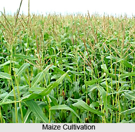 Economy of East Garo Hills District is basically agrarian and rural based. Agriculture is the mainstay of about 90 percent of the population of this district of Meghalaya and most earn their livings directly or indirectly from agriculture. Traditionally, agriculture in the district mostly includes cultivation of food crops and it is only in the recent years that cash crop agriculture has gained popularity. It is estimated that there is a great potential for agro-based industries in East Garo Hills District. Rice is the most important food crop of the district that is grown abundantly, both in the plains as well as in the hills. Other food crops that are widely grown in the district are tapioca or manoic, yam, maize and millets. Wheat is also grown but because of the low demand, much of the yield goes to markets outside the districts.
East Garo Hills District produces substantial quantities of fruits like oranges, pineapples, bananas and jackfruit and spices like chillies, ginger, turmeric and bay leaves. In recent years there has been an increase in the coverage of plantation crops like rubber, coffee, tea and cashew nuts. The increased demand for jute, mustard, ginger, cotton, rubber and other cash crops has also encouraged farmers to increase the area of cultivation for these crops. Improved road communication and marketing facilities as well as improved methods of cultivation and crop protection have also contributed to the increase in the production of food and cash crops. Irrigation has so far played only a minimal role in agriculture in the Garo Hills. The latest horticultural introduction in the district is vanilla vines. There is also scope for floriculture or flower farming to flourish, due to favourable climate enabling low cost cultivation. East Garo Hills District is ideal for growing orchids and tropical blooms like anthurium and bird of paradise (Strelitzia Reginae).
Although the economy of East Garo Hills District is largely agrarian, agriculture and agro-based industries has not been fully exploited in the district. There is tremendous potential for investment and development in food processing and ample scope for setting up a viable large scale fruit processing units in the district. Besides agriculture, a small part of the economy of East Garo Hills District is occupied in small-scale industries such as sericulture and weaving, animal husbandry and dairy farming, carpentry and bamboo-working, brick-making, etc. Mining is another important industry. The district has fairly large reserves of coal, limestone and clay.
Tourism in East Garo Hills District
Tourism in East Garo Hills District offers visits to several places of historical importance. Further it also includes those places of interest that have an association with the cultural traditions of Garo tribe. This region is also known for its magnificent scenic beauty. Tourism in East Garo Hills District includes falls and lakes that enhance the charm of the travelling experience of the visitors.
Some of the main attractions of East Garo Hills District are as follows -
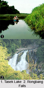
Ta`sek Lake: Formed by River Damring, this lake was believed to be the habitat of a huge water serpent called Sangkini by the locals. Located near Songsak block, this beautiful, natural inland lake is a popular camping site. The lake has an immense potential for pisciculture.
Rong`bang Falls: Locally known as Rong`bang dare, this waterfall is situated 25 miles away from Tura. It is a tributary of the Simsang River. This lively fall, though perennial, is at its best during the monsoon months. This waterfall is clustered on either side by vast evergreen hills of bamboo`s which sway that gives an ecstatic pleasurable experience.
 Domre Falls: Located just off the Williamnagar-Songsak road, near Dadengpara, this pleasant looking waterfall is small and is only of moderate size during monsoon.
Mokma Dare: Located at Mejolgre village, this beautiful waterfall falls from a great height and makes a deafening sound.
Nongalbibra: This important place is situated near the confluence of the Nongal and the Simsang Rivers in East Garo Hills District. There are rich deposits of coal in and around this place.
Naphak or Napak: It is situated about 6 km away from Songsak, the headquarters of the Songsak Development Block. The local Inspection Bungalow stands close to a beautiful lake called Ta`sek Lake, one of the most beautiful natural lakes found in the Garo Hills. The lake which is located in the middle of the village is very wide and deep. There are many varieties of fish in this lake.
Nongchram: This large village is situated on the Khasi Hills border in the eastern part of East Garo Hills District. It is 6 kilometers away from Rongjeng, the headquarters of the Dambo-Rongjeng Development Block.
Rajasimla: Located in the north-eastern corner of the district, Rajasimla is one of the earliest villages to be visited by the American Missionaries. The name Rajasimla was given to this place to commemorate the treaty between the Zamindar of Bijni and the villagers which recognized this particular spot as the boundary between the territory of the Rajah and the independent Garo villages. The place is of particular interest to Garo Christians as here American Baptist Missionaries laid the foundation of a church in the year 1867.
Williamnagar: It is the district headquarters of East Garo Hills District. Williamnagar is situated on the upper reaches of the Simsang River, and for this reason it was originally called Simsanggre, the name being changed in 1976 to Williamnagar, after the name of the first chief minister of Meghalaya, Captain Williamson Sangma.
 This place is becoming an important centre for cultural, educational and socio-economical activities.
Darugiri: At Darugiri, one comes across a vast expanse of Reserve Forest, covering an area of approximately ten-and-a-half square kilometres. The Darugiri Reserve Forest located between Songsak and Rongjeng consist of Sal plantations which stand elegant and tall, spreading an eternal canopy of emerald green over vast areas. It is considered as a paradise for the nature lovers.
How to Reach East Garo Hills District
Means of communication in East Garo Hills District are not much developed as it is a land-locked hilly terrain with sparse population. However, two National Highways pass through the district, forming the backbone of the road communication in the district. There are no railway heads and airports within the district and the rivers here are also not navigable. The nearest railway station is Guwahati in Assam. The nearest airport is the Lokpriya Gopinath Bordoloi International Airport at Guwahati.
Dainadubi, Mendipathar, Resubelpara and Rongrenggiri are some of the other attractions of East Garo Hills District. These tourism options of East Garo Hills District attract the people from different parts of the country. Tourism in this district of Meghalaya means a memorable and tranquil experience.