 Akola district is one of the districts located in the state of Maharashtra. Akola District, with the rest of Berar was assigned to the British East India Company by the Nizam of Hyderabad following the Treaty of Assignment of 1853. After the Province was assigned to the Company it was divided into two districts, East Berar and West Berar, Akola being the headquarters of the latter. In 1903 the Treaty of Assignment was superseded by an agreement under which the Nizam ceded Berar to the Government of India in perpetuity. Administration of Berar was then transferred from the Resident of Hyderabad to the Chief Commissioner of Central Provinces. The area which now forms the present Akola district was created by the transfer of Murtizapur tahsil from Amravati to Akola district and by the transfer of Khamgaon and Jalgaon tahsils from Akola to Buldhana district. Washim district was broken up and two of its tahsils, viz., Washim and Mangrul, were included in Akola district. The famous `Mahabeej` factory, producing super-quality seeds is located here. Vidarbha`s only Agricultural University is also situated here. Narnala fort in Akot taluka, Parshwanath Jain Temple of Shirpur, Rajrajeshwar temple, power generation plant of Paras, the irrigation project in Mahan on Katepurna river are among the places of tourist attraction.
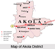
Location of Akola District
The district of Akola lies in the western parts of the Nagpur Division of Maharashtra State and is surrounded by Amravati district in the north and north-east, Yavatmal district in the south-east, Parbhani district in the south and Buldhanat distric in the west. The district lies between 19 degrees 51 minutes and 21 degrees 16 minutes latitude and 76 degrees 38 minutes and 77 degrees 44 minutes longitude. It has a total area of 10,567 square kilometres.
History of Akola District
History of Akola District has seen it undergoing a long process of organisation and re-organisation till it was finally constituted into present-day Akola. Akola district was initially a part of the Nizam`s dominion. It was assigned in 1853 to the British East India Company in liquidation of the large debt due on account of arrears of pay on the Hyderabad contingent and as a security for future payment of that force. At that time Berar was divided into two districts, South and North. In 1857 Berar was reconstituted into two districts, West Berar with headquarters at Akola and East Berar with headquarters at Amravati.
The administration of Berar was transferred from Hyderabad to the then Chief Commissioner of Central Provinces. In 1864, when the district of Buldhana was constituted, a part of the west Berar district was transferred to Buldhana district. In 1875, again when the Washim district was created some parts were transferred and the district and tahsil boundaries were completely overhauled in 1905. Murtizapur tahsil was transferred from Amravati to Akola district and Khamgaon and Jalgaon tahsils were transferred from Akola to Buldhana district. The Washim district was broken and two tahsils of Washim and Mangrulpir were included in the newly constituted Akola district. There were no major changes in the boundaries of the district between 1911 and 1955. In 1956, with the Reorganisation of the States, the district was transferred from Madhya Pradesh to the then Bombay State and in 1960 it became a part of the State of Maharashtra.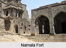
On first July 1998, Akola district was divided to form two new districts - Akola and Washim. Akola district now consists of Akola, Balapur, Patur, Barshitakli, Murtizjapur, Akot and Telhara talukas. The district headquarter is Akola.
Akola city is located in north-central Maharashtra state, western India, on the Morna River. An important road and rail junction in the Purna River valley, it is a commercial centre trading chiefly in cotton. There are also textile and vegetable-oil industries. Akola is an important educational center with several colleges affiliated with the University of Amravati.
 Geography of Akola District
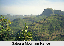
Akola district lies between 19 degrees 51minutes and 21 degrees 16 minutes latitude and 76 degrees 38 minutes and 77 degrees 44 minutes longitude. In relief, the district shares a similarity of topographical arrangements as found in Buldhana district. It also falls into three physical units- a narrow northern strip in the Akot tahsil in the Satpura foot-hills, the Payanghat or Purna plains in the middle, occupying nearly half the district area in the tahsils of Akot, Balapur, Akola and Murtizapur and the Balaghat on the top of the Ajanta ranges comprising Washim and Mangrulpir tahsils to the south.
The landscape in the district though not highly hilly, still offers interesting contrasts between the plateau and the plains, further enriched by a forested ghat country and a bad land topography joining the Mun river. The two main rivers of the district are the Purna River and the Penganga River, the other less important rivers being the tributaries of these two rivers. They are the Katepurna, Shahanur River, Morna, Mun, Nand, Man and Uma, which are the tributaries of the Purna, and the Adan River, the Arna and the Pus which are the tributaries of the Penganga.
The climate of this district is characterized by a hot summer and general dryness throughout the year except during the south-west monsoon season. The year may be divided into four seasons. The period from about the middle of November to the end of February constitutes the winter season. The summer season extends from March to June. This is followed by the south-west monsoon season which extends up to the end of September. October and November constitute the post-monsoon season. Temperature rises rapidly after February till May which is the hottest month of the year. In May, the mean daily maximum temperature at Akola is 42.4 degree Celsius and the mean daily minimum temperature is 27.5 degree Celsius.
The heat in the summer season is intense during the day and the nights are comparatively tolerable. During the period from April to June, on individual days, the day temperature raises upto about 46 degree Celsius or 47 degree Celsius With the arrival of the south-west monsoon in the district by about mid-June there is an appreciable drop in the day temperature and the weather becomes pleasant. Both day and night temperature decreases rapidly from October till December, which is the coldest month in the year. The mean daily maximum temperature during this month is 29.3 degree Celsius and the mean daily minimum temperature is 11.9 degree Celsius. In the rear of the western disturbances, which move across north India in the winter months, cold waves affect the district at times and night temperatures may go down to about 2 to 4 degree Celsius. Except during the south-west monsoon season when the humidity is between 60 to 80 per cent, the air is generally dry over the district. The summer months are the driest when the relative humidity is even less than 20 per cent in the afternoons on many days.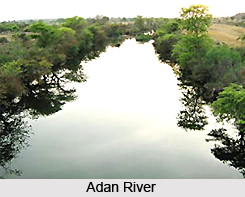
Economy of Akola District
Agriculture dominates the rural economy and even the urban landscape to a considerable extent. Manufacturing and household industry barely account for 15 percent of the working population while services, trade and commerce account for a greater proportion in this district. Factory manufactures are insignificant and relatively recent. Industries are agro-based, viz. cotton ginning and pressing, spinning and weaving, and flour mills, oil crushing and dal mills.


