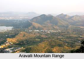
 Dausa district is located in the state of Rajasthan, in the Jaipur Division. It is surrounded by 6 districts, namely- Tonk, Sawai Madhopur, Karouli, Bharatpur and Alwar. Occupying a total area of 3404.78 sq. kms, the district is roughly semicircular, or C-shaped, tapering towards the eastern and western corners. The hills found in the district belong mainly to the Aravalli Mountain ranges. The Lalsot-Bayana Hill range, runs from Lalsot to Bayana, and demarcates the boundary between Dausa and Sawai Madhopur districts. The Aravalli exposures have a perfect concordant sequence of beds from Lalsot to Bayana ridge. A belt of crystalline quartzite is found in the hills from Dausa to Bhankari, schistose quartzite is also predominately exposed. Morel and Ban Ganga are the major rivers located in the district.
The soil of the district is yellowish to dark brown, mostly fine textured, generally suitable for all type of crops. Further, a watershed scheme has been implemented in the district to avoid erosion. The district has 219575 hectares of arable land of which about 128169 hectares 58.92 percent is under irrigation. Crops are grown here according to the Kharif and Rabi season. The principal crop of the district in Kharif is Bajra. The most important food grain crop in Rabi is wheat. During Kharif season; groudnut is produced in irrigated areas. Maize also requires irrigation. Generally other crops are sown at the commencement of the rainy season. Groundnut, maize and cotton are sown by broadcasting the seeds. Fertiliser is applied before sowing of groundnut and cotton. During Rabi, mustard and gram is sown from September to October, in unirrigated land, while in the irrigated land, barley, gram and mustard are sown in October-November and wheat in November-December. The district has 94652 hectares of double cropped area with crop cycles of moong-wheat, groundnut-wheat, moong-mustard, bajra-mustard, bajra-gram etc. The major sources of irrigation in the district are wells and tube wells. A large part of the irrigation in the area is covered by these sources. Besides this, a very limited area is irrigated through small rivers and ponds. There are a total of 36 dams in the district. The most important ones are Sainthal Sagar, Kalakho Bandh, Madhosagar Bandh and Moral Bandh.
Dausa district falls under the Indus Plains floristic region of India. Each region has its distinctive species. This district is endowed with Acacia nilotica ( Babool ), Asenegal (Kumta), Anogeissus (Dhok), Prosopis (Khejadi), Capparis(Kair) and Caotropis (Ak). This vegetation is typical of tropical thorn forests. The district is endowed with a variety of habitats. Although not rich in dense forest growth, Dausa sustains considerable biological diversity. As far as the fauna is concerned, the district falls under the Oriental region. Of the characteristic wildlife of the region, the wild animals still surviving in the district include the monkey, lemur (langur), panther, black buck and peafowl.


