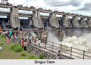
 The government of India completed work on the Singur Dam by 1989 in Andhra Pradesh. World Bank-supported Hyderabad Water Supply and Sanitation Project was in charge of the dam and its functions later. The reservoir created by the dam was the chief source of irrigation water, electric power and drinking water in the surrounding areas.
Owing to the construction of the dam, thousands of people had to relocate their dwellings, and therefore lost their livelihoods. Later, the Hyderabad Water Supply and Sanitation Project extended its responsibilities to the resettlement and rehabilitation of people displaced by the rising water. The project also helped to relocate 3,600 households and identified 4,600 families that needed support to re establish their economic productivity.
This article is a stub. You can enrich by adding more information to it. Send your Write Up to content@indianetzone.com


