 Barakar River is the prime tributary of Damodar River. It is one of the tributaries of River Damodar. The main tributaries of Damodar River are Barsoti and Usri that flow in from the south and north respectively. Apart from the two main tributaries of Damodar River, around fifteen medium and small streams also join it. Barakar River flows in all rage during the rains and has washed away two bridges constructed successively on the Grand Trunk Road.
Course of Barakar River
Barakar River starts near Hazaribagh district of Jharkhand, flows for 225 kilometres across the northern part of the Chota Nagpur plateau, mostly in a west to east direction. It finally joins the Damodar River near Dishergarh in Bardhaman district of West Bengal. It has a catchment area of around 6159 kilometres.
Geography of Barakar River
The Barakar River flows in the boundary of the northern portion of Parashanth Hill at an elevation of 1350 metres or 4470 feet. The highest hill in the region is located in Giridih district of Jharkhand which is a centre of Jain pilgrimage.
Fisheries of Barakar River
The reservoirs at Tilaiya Dam and Maithon Dam had ample scope for development of fisheries. The plans did not follow accordingly largely due to the alarming presence of predatory catfish W. attu and other predators such as Notopterus chitala, Barilius bola at Tilaiya, catfishes Wallago attu and Aorichthys aor, at Maithon. These predators are ferocious and eat the stocked carps Trash and fishes form Tilaiya reservoir. The main species of catch at both the places are catla, mrigala, rohita and calbasu.
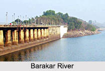
Dams and Bridges on Barakar River
Barakar River flows ferociously during the monsoon months. The great stone bridge across the river near Barhi, in Hazaribagh district was built around 1848, was washed away in 1913. The small iron bridge was again built to replace it. This bridge withstood the strains of troop movement during the Second World War, but gave way in 1946, with another great flood. Tilayia was DVC`s (Hydroelectric Power Plant) first dam was across the Barakar at Tilayia, in Hazaribagh district of Bihar, which is now in Jharkhand.


