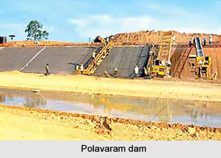
 The Polavaram Dam is strategically located on Latitude 170 13` N and Longitude 810 46` E. Sited near Polavaram village of the west Godavari district of Andhra Pradesh, this Dam is 2310 m long and 48.32 m high. The catchment area of the Polavaram Dam is 306643 sq km. The Polavaram Dam site experiences around 1023 mm rainfall annually. The live storage of the dam is 75.2 TMC. Other than irrigational purposes, the dam is also used for the purposes like water supply to Vizag (23.44 TMC), Chhatisgarh (1.5 TMC), Orissa (5 TMC) and Godavari Delta (274.57 TMC). The installed capacity Power 12x80 MW
Several organizations in Andhra Pradesh and other communities raised their voices against the Polavaram Dam project due to some adverse effects. The project was said to bring misery to more than 2.0 lakh people, by submerging and displacing 276 villages, mainly the tribal villages in an area of about one-lakh acres including forestland. However, the centre and the state governments adopted the project and its estimated cost was Rs 9 265 crores but recently the amount was added by the chief minister upto 20,000 crores.
After certain modifications, the design of the Polavaram Dam was made in a way so that the ecology and the lifestyle of the people are not hampered. The Dam is constructed straight across the Godavari River some 15 km north of Rajmundhry in east Godavari district. The Dam will be constructed at a level of 150 feet (47 m). The Right Main Canal will supply 226 MCM water to Budameru in Vijayawada. This canal opens into Krishna River upstream of Prakasam barrage. Thus this 174 km long canal will connect the Godavari and Krishna rivers. This canal will be navigated through freight boats. The Left Main Canal will cater to the water requirements of the 12 lakh acres in north coastal districts besides providing drinking water in the surrounding urban and rural areas. It will also supply irrigational water to the north coastal districts of Visakhapatnam, Vizianagaram and Srikakulam.


