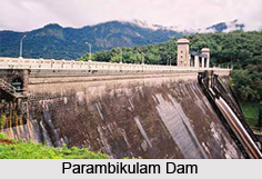
 Parambikulam Dam is designed as an embankment dam on the Parambikulam River, included in the Palakkad district in the Western Ghats of Kerala, India. The dam is located near Udumalaipettai city in Kerala. Parambikulam Dam is known as one of the finest dams in India as well as one of the best embankment dams in the world in volume capacity as recorded in the year 2000.
Kerala was supposed to receive 7.25 TMC feet of water per year from the Parambikulam Aliyar Project, according to the state agreement with Tamil Nadu. The Parambikulam Dam is a part of Parambikulam Aliyar Project. In 2004, Kerala did not receive any water until February. Thus paddy in thousands of acres in Chittur taluk dried. The agreement of Parambikulam Aliyar Project started officially since July 2006; Kerala Water Resources Minister has called for a review of the project agreement for better execution.
This article is a stub. You can enrich by adding more information to it. Send your Write Up to content@indianetzone.com


