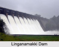
 The Karnataka State Government constructed the Linganamakki dam in 1964. This dam is located at a distance of 6 km from the world famous Jog falls in the premises of Sagara taluk near Kargal town. Linganamakki dam has a length of 2.4 km, extending across the Sharavathi River with a higher water storage capacity than any other dam.
Structure of Linganamakki Dam
The dam was designed to hold 4368 million cubic meter of water in an area of around 300 sq. km, submerging 50.62 sq. km of swamp land and 7 sq. km of arid land, with the remaining forest land and wasteland. The dam rises to a height of 1819 feet above sea level. The Linganamakki dam receives water mainly from rainfall and also from the Chakra and Savahaklu reservoirs, which are linked to Linganamakki through a canal. The water from the Linganamakki dam flows through a trapezoidal canal into the Talakalale Balancing Reservoir. The discharge capacity of this canal is around 175.56 cumec. This channel is about 4318.40 m long with a submersion of 7.77 sq. km. Encompassing a catchment area of about 46.60 sq. km, the gross capacity of the reservoir is 129.60 cu meter. There is a large reservoir behind the dam and the discharge from the dam can be quite heavy.
Tourism in Linganamakki Dam
Many tourists also visit this spot, when the dam`s sluice gates are kept open. While the gates are closed upstream from Jog Falls, often nature lovers walk down into the fall`s ravine. The dam generates 27.5 MW power.
Visiting Information to Linganamakki Dam
The best time to visit this place is in monsoon season because of the heavy rainfall. Nearest airport of this place is in Mangalore and nearest railway station is in Shimoga.
This article is a stub. You can enrich by adding more information to it. Send your Write Up to content@indianetzone.com


