There is enormous potential for Tourism in West Godavari District, because of its convenient location and easy internal transportation of religious Monuments, Temples and endowed with rich historical or archaeological legacy. The places of religious temples, institutions and historical or archaeological significance in the district are presented briefly hereunder. All hard works are done by the District Authorities for bringing about complete tourism development in the district, keeping in mind its vast potentiality and ample scope in this regard. Some of the places of pilgrimage near River Godavari are as follows -
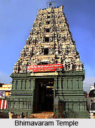
Bhimavaram -The place is best known for the big Naturopathic Hospital located amidst an extensive garden. Among the several temples in this place, Bhimeswara and Someswara are the vital ones. The Sivalingam in the temple of Bhimeswara is said to be Swayambhu Lingam and the Sivalingam in Gunupudi Someswara temple is also said to be a Swayambhu. The place is one of the five Aramas or the Pancharamas, while the other four are the Amaravathi, Bheemarama near Samarlakota and Draksharamam both in East Godavari and Kshira Ramalingeswara of Palacole in the District.
Dwaraka Tirumala - This place is considered for its religious importance in Hinduism. The deity of this temple is of the Lord Venkateswara which also locally known as "China Tirupathi" at a distance of 40 Kms from Eluru.
Palacole - Palacole was previously known as Palakota and Palakolanu and is situated 10 Kms from Narasapur. The most important spot of interest in this town is the Kshira Ramalingeswara Temple, which is one of the Pancharamas.
Pattisam - Pattisam is situated at a distance of 25 Kms from Kovvuru Railway Station. It is one of the prehistoric and sacred places in South India. The religious importance is due to the shrines of Veerabhadra and Bhavanarayana located on the Devakuta Parvatam hanging on the Papi Hills in the heart of River Gowthami - a branch of River Godavari.
Juttiga and Natta Rameswaram (Dakshina Kasi) - Juttiga and Natta Rameswaram are twin villages retaining religious importance because of the presence of the temples of Swayambhulingam known as Sri Uma Vasuki Ravi Someswara Swamy at Juttiga Village. The lingam that is made of shells and cones is called the Natta Ramalingeswara Swamy at Natta Rameswaram Village. On every Shivratri festival day "Edurukolotsavam" is celebrated at the border of two villages. Thousands of pilgrims attend those celebrations. It is one of the important piligrim centers in the District.
Penugonda - This place is the Mandal Headquarter and the importance is owed to be the birthplace of Kanyakaparameswari, the goddess of the Vaisyas. The temple of Kanyakaparameswari is the most significant religious institution in the town.
 Pedavegi - Pedavegi is originally known as Vengi. The capital of the Salankayanas, Vishnukundins and the East Chalukyas was a flourishing city at the time of Satavahanas. It is a petty village now with a few noticeable landmarks.
Khandavalli - This village stands at a distance of 12 Kms from Tanuku. Khandavalli is an antique village situated on the banks of Vasista Godavari. This village is also called the panchalingakshetram owing to the existence of five Sivalingam in the temple of Markandeswara - Mrukandeswara. This strange occurrence of five lingams in a temple is found only at Benaras and Rajahmundry. Hence this place is considered to be of religious importance.
Tanuku - Tanuku is the Headquarters of the Mandal and is best known for being the birthplace of Adikavi Nannaya Bhattaraka, who was the famous translator of telugu. He translated the Mahabharatha written by Sage in Vedavyasa Sanskrit.
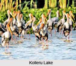
Kolleru Lake - Kolleru Lake is one of the fresh water and natural formed huge lake in the country, this is partly situated in West Godavari District and the remaining part is situated in Krishna District. Four decades back, it was found that nearly 193 varieties of birds existed here. However, presently most of the varieties of birds are not seen there due to increase of water pollution and also atmosphere due to various reasons.
Jainism spots - The Temple of Pradhama Teerthankara or Adhinadhudu of Jainism at Pedamiram village near Bhimavaram town and on a big stone image of sitting posture statue of a Jaina Tirthankara at Penumanchili of Achanta Mandal are instances of existence of Jainism in West Godavari District. In every year the anniversary day of Adhinadhudu at Pedamiram village is celebrated on Karthika Poornima day with grandeur, pomp and show.
Budhism spots - The remains of ancient `Sangharam` at Jeelakarragudem, H/o Guntupalli Village of Kamavarapukota Mandal, include a group of Rock-cut Chambers i.e. Caves, remains of a Brick-built Chaitya Hall and many "Sthupas" in different sizes, mostly rock-cut and a few structural, reveals that Buddhism was existed here some centuries ago. This place is picturesquely positioned amidst hills of charming beauty.
The history of Guntupalli caves dated back to 200 B.C. Thousands of people still visit this historical place and it is believed that the entire development and expansion of its growth was during the centuries of 2nd B.C. to 3 rd A.D. In the entire Sangharam of this place, either in rock-cuts or in structures, Gautama Buddha picture impressions are not found. So it is evident that "Heenayanam" Buddhist culture i.e. early ages of Buddhist culture still prevails in this place.


