The origin of Indian rivers actually trace back to their source of flow from the Himalayas. The origin of Indian Rivers dates back to the birth of Indus River and the formation of Indus Valley civilization. The Rivers of India can be categorized as Himalayan, peninsular, coastal, and inland-drainage basin rivers. Himalayan Rivers are snow fed and sustain a high to medium rate of snow flow throughout the year. The heavy annual average rainfall levels in the Himalayan catchment areas additionally increase their rates of flow. During the monsoon months of June to September, the catchment areas have the possibility of flooding.
The Indian River Systems can be divided into four sections - the Himalayan, the rivers traveling across the Deccan Plateau, the Coastal and those in the inland drainage basin. The Himalayan Rivers are perpetual or perennial as they are fed by melting glaciers every summer. During the monsoon months, these rivers assume shocking volume. Swollen with rainwater, these rivers often engulf villages and towns in their path. The Gangetic basin is the largest river system in India, draining almost a quarter of the nation.
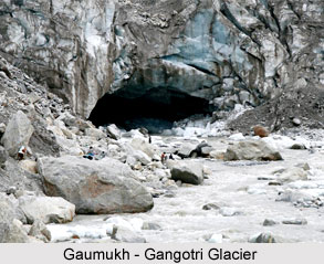
 The Ganga River basin is India`s largest and comprises an integral part of discussion in the history of Indian rivers. This basin includes around 25 % of the nation`s surface area. The Himalayas in the north and the Vindhya Range to the south surround the Gangetic basin. The Ganga has its source in the glaciers of the Greater Himalayas, which form the frontier between India and Tibet in northwestern Uttar Pradesh. Many Indians believe that the legendary source of the Ganga, and several other significant Asian rivers is in the sacred Mapam Yumco Lake or well known to the Indians as Manasarowar Lake of western Tibet. This lake is located approximately 75 kilometers northeast of the India-China-Nepal convergence point. In the northern part of the Ganga River basin, practically all of the tributaries of the Ganga are perennial streams. However, in the southern part, located in the states of Rajasthan and Madhya Pradesh, most of the tributaries are not permanent.
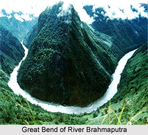
The Brahmaputra has the maximum volume of water of all the rivers in India because of heavy annual rainfall levels in its catchment basin. At Dibrugarh the annual rainfall averages 2,800 millimeters, and at Shillong it averages 2,430 millimeters. Rising in Tibet, the Brahmaputra flows south into Arunachal Pradesh after breaking through the Great Himalayan Range and drops rapidly from great altitude. It continues to fall across the gorges that are impenetrable by man in Arunachal Pradesh until finally entering the Assam Valley where it moves westward on its way to merge with the Ganga in Bangladesh.
The Mahanadi River rising in the state of Madhya Pradesh is an important river in the state of Orissa. The upper drainage basin of the Mahanadi is centered on the Chhatisgarh Plain, episodic droughts seems to be a contrast with the situation in the Oriya delta region where drastic floods often damage the crops in what is known as the rice bowl of Orissa. Hirakud Dam that was constructed in the middle reaches of the Mahanadi. This has helped in rectifying the adverse effects by creating a reservoir.
 The source of the Godavari is in the northeast of Bombay in the state of Maharashtra, and the river follows in the direction of southeast and along a course for 1,400 kilometers to its mouth on the Andhra Pradesh coast. The Godavari River basin area is second in size next to the Ganga; its delta on the east coast is also one of the country`s major rice-growing areas. River Godavari is popularly known as the "Ganga of the South," but its free flow, despite the large catchment area, is moderate because of the moderate levels of annual rainfall. About 700 millimeters rainfall at Nasik and 1,000 millimeters at Nizamabad is the average picture of the region.
The Krishna River rises in the Western Ghats and flows eastwards into the Bay of Bengal. It has a deprived flow because of low levels of rainfall in its catchment area, around 660 millimeters annually at Pune. In spite of its medium discharge, the Krishna River is the third longest river in India.
The source of the Kaveri lies in the state of Karnataka, and the river flows southeastward. The waters of the river have been a source of irrigation since ancient times; in the early 1990s, an estimated 95 %of the Kaveri River was abstracted for agricultural use before emptying into the Bay of Bengal. The delta of the Kaveri is so mature that the main river has almost lost its link with the sea, as the Kollidam, the distributaries of the Kaveri, bears most of the flow.
The Narmada and the Tapti Rivers are the only major rivers that flow into the Arabian Sea. The Narmada rises in Madhya Pradesh and crosses the state, passing swiftly through a narrow valley between the Vindhya Range and spurs of the Satpura Range. It flows into the Gulf of Khambhat (or Cambay). The shorter Tapti follows a generally parallel course, between eighty kilometers and 160 kilometers to the south of the Narmada, flowing through the states of Maharashtra and Gujarat on its way into the Gulf of Khambhat.


