Home > Indian History > Geography of India > Indian Bauxite Mines
Indian Bauxite Mines
The major impurities in bauxite are clay minerals and iron oxides.

Share this Article:

Indian Bauxite MinesA rock mainly comprising minerals that are hydrous is aluminum oxides. These minerals are gibbsite, boehmite, and diaspore. Bauxite is a weathering product of aluminous rock that results from intense leaching in tropical and subtropical areas, a process called laterization. Bauxite deposits are generally found on plateaus in stable areas where they had sufficient geologic time to form and were protected from erosion. Bauxite is the primary ore of aluminum. The two types of bauxites that are used commercially as aluminum ores are laterite and karst. Lateritic bauxites constitute more than three-fourths of the world`s bauxite resources.

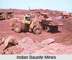
Karstic bauxites are formed on a carbonate ground and are concentrated in sinkholes and solution depressions on the surface of carbonate rocks. Bauxite used to produce alumina is called metallurgical grade; approximately 90% of the world`s production is for this purpose. Other major uses are in refractories, abrasives, chemicals, and aluminous cements. The compositional requirements are much more rigid for these uses. The alumina content must be higher, and the iron, silica, and titanium contents significantly lower, than for metallurgical-grade bauxite. World resources of bauxite are many tens of billions of tons, so an adequate supply is assured for hundreds of years. Bauxite does not require complex processing because most of the bauxite mined is of an acceptable grade or can be improved by a relatively simple and inexpensive process of removing clay.


Share this Article:

Related Articles

More Articles in Geography of India


Geography of Uttar Pradesh
The fourth largest State in India UP is located in the Northern part of India whose area is 2,36,286 sq Kms.
Geography of Maharashtra
Covering an area of 308,000 sq. km, Maharashtra, the third largest state in India.
Geography of Kerala
Geography of Kerala includes plains, hills, valleys and coasts. With the Arabian Sea in the west, the Western Ghats in the east and networked by several rivers, Kerala enjoys diverse geographical features.
Geography of West Bengal
The geography of West Bengal is unique with high peaks of the Himalayan range in the north, the Bay of Bengal in the south and the remaining region is covered with both plains and plateaus.
Geography of Jharkhand
Geography of Jharkhand is comprised of the rich mineral resources and the highly agricultural prospect in this state.
Geography of Sikkim
Geography of Sikkim is characterised by a vast array of magnificent hillock that extends from one corner of the state to the other.
Geography of Meghalaya
The suitable climate, highland plateaus, rivers and the flora and fauna together forms the geography of Meghalaya.
Geography of Mizoram
Mizoram is surrounded by hills, valleys, rivers, waterfalls and lakes. The hills range from 1000 meters to 2000 meters. Rivers, lakes and waterfalls also play major role in forming the land of Mizoram.
Geography of Jammu & Kashmir
Jammu and Kashmir is encompassed by valleys. Some of the dominant valleys of the state are Kashmir Valley, Tawi Valley, Chenab Valley, Poonch Valley, Sind Valley and Lidder Valley etc. Jhelum River is the only major Himalayan River which flows through the Kashmir valley. Indus, Tawi, Ravi and Chenab Rivers are the major ones flowing through the region.
Geography of Daman and Diu
Daman and Diu is situated on the west coast of India and are the smallest union territories of India.
Geography of Goa
Geography of Goa occupies a prime location along the Konkan coastal belt on the western coast of India. The state is bordered by Maharashtra in the north and Karnataka in the south. The Western Ghats in the east contribute to the flora and fauna of Goa.
Geography of Arunachal Pradesh
Geography of Arunachal Pradesh reveals that it is a hilly tract nestled in the foot of Himalayas.
Geography of Kutch
Geography of Kutch District is covering an area of 45,612 km. Kutch District is the largest district in the state of Gujarat.
Geography of Ladakh
Geography of Ladakh mainly comprises the huge Karakoram Range with long stretch of cold desert which mark the region separately from the rest of the states of Indian subcontinent. Surrounded with the mountain ranges from all corners this small region separates Indian subcontinent from rest of the Asian continent.
Geography of Rajasthan
Geography of Rajasthan defines the dry topography with arid climate of the western mountain region.
Geography of Tamil Nadu
The Indian state of Tamil Nadu is located in the Northern hemisphere in the hot zone.