 Puri District is the coastal district of Odisha and it is known for the famous temple called Jagannatha Temple. The district of Puri holds wealth of attraction for the visitors and at the same time boasts of a continuous history from the 3rd Century BC and its unique monuments like those of Lord Jagannath at Puri, the Sun God at Konark, which attained prominence and reputation not only in India but throughout the world. However, Puri District is known as the holy as the holy seat of the celebrated Lord Jagannath.
Puri District
Puri District is famous and the popular destination in Eastern India. It is popular for its historic antiquities, religious sanctuaries, architectural grandeur, seascape beauty and moderate climate, which is alluring to every Bengalese people.
Introduction
Puri District is the coastal district of Odisha and it is known for the famous temple called Jagannatha Temple. The district of Puri holds wealth of attraction for the visitors and at the same time boasts of a continuous history from the 3rd Century BC and its unique monuments like those of Lord Jagannath at Puri, the Sun God at Konark, which attained prominence and reputation not only in India but throughout the world. However, Puri District is known as the holy as the holy seat of the celebrated Lord Jagannath.History of Puri District
 History of Puri District, Odisha asserts the development and growth of this region ever since pre-historic times, continuing through the medieval period and also traces the nomenclature of this Indian district. Various kinds of stone tools derived from Puri, Odisha District suggest about the ancient pre-historic life existent in this portion of the country. Stone tools have been discovered from numerous areas which include Sundargarh, Mayurbhanj, Keonjhar and Dhenkanal, which have yielded formations of `murrams`, river gravels, secondary laterite pits and so on.
Etymology of Puri District : The headquarters town of Puri has inspired the nomenclature of the district `Puri`. The Chinese traveller Hieun Tsang had claimed that the old name of this place was `Charitra`, which he had referred to as `Che-li-ta-lo`. This particular fact had also been mentioned by Cunningham.
Medieval History of Puri District : Following the erection of the temple of Jagannath at Puri District, the significance of Puri as a crucial centre of Vaishnavism was enhanced, particularly after the establishment of the deities of Lord Jagannath, Devi Subhadra and Lord Balabhadra. Soon afterwards, Puri became renowned as the `Purusottama Kshetra`. The `Nagari` plate of Anangabhima III belonging to Saka year 1151 to 1152 or 1229 to 1230 A.D, reveals that this area was termed as the Purusottama Kshetra.
The Marathas, Mughals and also the early British governors used the word `Purusottama Chhatar` while mentioning Puri. Kalika Purana and `Yogini Tantra` both have suggested that the district was called Purusottam, though this region was also referred to as `Utkal`. Sometimes, Purusottama Kshetra was also known as `Purusottama Puri` or shortened into `Chhatra` or `Kshetra`. Certain British records have indicated that Puri District was also termed as `Pooree` but currently, the name Puri is the most popular.
Odisha was subdivided into three `circars` under the Mughal regime (1592 to 1751) which was titled as `Kataka`, `Jaleshwar` and `Bhadraka`. Each of the circars was further classified into `Bishis` and Kataka circar`s portion was Puri District. Certain transformations were introduced by the Marathas in Puri, after they conquered this region during 1751.
Modern History of Puri District : Thereafter, Odisha was divided into five `Chalakas` of Balasore, Pipli, Soro and Kataka. Large tracts of land of Puri belonged to Pipli Chalaka. Chalakas were again classified into `Parganas` which were again subdivided into `Taluqs` or `Mahals`. When the British invaded Odisha during 1803, more changes were incorporated in the revenue divisions of Odisha and in 1804 Northern and Southern Divisions were the two final divisions of this province, wherein Mahanadi River acted as the boundary. However within 1805 both divisions were merged together.
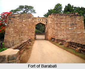
The Raja of Khurdha rebelled in 1804 and consequently he was imprisoned at Cuttack, in the Fort of Barabati. He was duly released after his empire was captured and he was allowed to reside in Puri, at Balisahi. During that time he served as the superintendent of the Jagannath Temple at Puri. Till the year 1816, Puri functioned as the capital of Odisha and the official headquarters of the collector. During 1806, the headquarters was proposed to be shifted to Jajpur but it failed to receive the sanction of the Government. The establishment of the collector was then moved to Cuttack during August 1814 which was again changed to Puri in the month of December. Yet again the headquarters was moved to Cuttack during the reign of Marathas and Mughals. Puri was under the jurisdiction of a joint Magistrate which supervised Kiran, Thana of Pipli, Hariharpur and Gop from 1813 to 1819. By the year 1819, Khurdha was entrusted the responsibility of taking care of the above `thanas`. However, Odisha was again divided into two divisions on 11th February, 1822 and the office of the joint magistrate was declared null and void.
Odisha was yet divided into three districts consisting of Jagannath, Balasore and Cuttack during 23td October, 1828 which was later referred to as Puri. H. Ricketts, R. Hunter and W. Wilkinson were the very first magistrate and collectors of the regions of Balasore, Cuttack and Puri respectively. Odisha became an independent province in 1936. Khandapara, Nayagarh, Daspalla and Ranapur were included as portions of Puri District which possessed its headquarters at Puri. Nayagarh, Khurdha, Bhubaneshwar and Puri Sadar were the sub divisions of the old Puri District. Four `tehsils` known as Krushna Prasad, Pipli, Nimapara and Sadar made up the District of Puri.
Puri District was again divided into three different districts by 1995 which included Puri District which comprised Puri Sadar Sub-Division, Khurdha District which comprises Bhubaneshwar and Khurdha Sub-Division and Nayagarh District which comprised Nayagarh Sub-Division.
Geography of Puri District
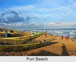
Geography of Puri District may be divided into two dissimilar natural divisions - littoral tract and level alluvial tract. The littoral tract lies between the alluvial tract and the Bay of Bengal. The level alluvial tract is full of villages and rice fields. There is no hill in Puri District except a small cultivate land are under plough. The length of the sea-coast of the district is nearly 150.4 km. All the rivers of Puri District have a common characteristic. In the hot weather they are beds of sand with tiny streams or none at all, while in the rains they receive more water than they can carry. Generally all rivers are distributaries of Mahanadi River. By virtue of its geographical location, the climate of Puri District is equable through out the year.
Demography of Puri District
Puri district has a population of 1,697,983. This gives it a ranking of 291st in India out of a total of 640. The district has a population density of 488 inhabitants per square kilometre (1,260/sq mi). Its population growth rate over the decade 2001-2011 was 13%. Puri has a sex ratio of 963 females for every 1000 males, and a literacy rate of 85.37%.
Education of Puri
 Ghanashyama Hemalata Institute of Technology and Management, Gangadhar Mohapatra Law College, Shri Jagannath Sanskrit University, Samanta Chandra Sekhar College are the popular educational institutions here.
Economy of Puri
The economy of Puri is dependent on Jagannath Temple and Puri Beach. Ratha Yatra and other festivals are the most important which are attended by millions of people every year. The Sand art and applique art are some of the important crafts that generate revenue to Puri.
Art and Culture of Puri District
Art and culture of Puri District, Odisha is a unique combination of the colourful cultural heritage which has been prevalent in this part of the country since times immemorial. It is believed that since 3rd century BC, Puri is enriched with rich cultural tradition and customs, in the form of its various types of art-forms, dances, folk dances, music, fairs and festivals. Moreover, Puri is often referred to as the cultural capital of the eastern- Indian state of Odisha. The regional inhabitants of Puri engage in numerous activities which reflect their purity in the sphere of arts and culture. Puri Beach Festival, Gosani Yatra, Gundicha Utsav and different cultural events portray the vibrant culture of Puri District.
Puri District is also revered for its rich artistic heritage which manifests itself through wonderful palm-leaf paintings, `tussar` paintings, pottery -ware, toys, `Patachitra` paintings, mache products, applique crafts and the unique sand art.
Sculptural Art in Puri District : Puri has earned repute amongst travellers, pilgrims and tourists who keep pouring into this district to catch sight of the magnificent architectural grandeur and sculptures existent in the well-known temples located here. Architectural styles of the Jagannath Temple, Sun Temple at Konark, Mangala Temple, Jambeshwar Temple, Lokanath Temple, Gundicha Temple, Sakhigopal Temple, Harihar Temple, Mohabir Temple, Amareswar Temple and numerous others. The stone sculptures found here are worth mentioning.
Performing Arts of Puri District : Odissi is the traditional dance of Odisha, and has been practised in Puri and other parts of this Indian state since ancient times. Currently, this dance has developed into a highly matured and elegant dance form. Odissi was practised by the temple dancers or `Devadasi` according to the `Mahari` tradition, since it is believed that Lord Jagannath is quite fond of songs, music and dances. Some folk dances are also performed here which comprise Naga and Medha dance, Gotipua Dance, Navrang Dance, Pala Dance, Bhalunacha Dance, Daskathia Dance, Dhudki Dance, Ghoda Dance and others.
An important theatre known as Annapurna Theatre presents frequent theatrical performances and opera is a popular dance-drama show which is practised here. This organization coordinates with organizations like Odisha Sangeet Natak Academy and Odisha Sahitya Academy which are notable institutes of arts and culture in Puri, and together they organise different cultural performances. The District Council of Culture conducts cultural events every month at the Urban Haat Conference Hall to encourage talented personas.
Cuisine of Puri District : The cuisine of Puri District is varied and appeals to the taste of food lovers. Many kinds of seafood, fruits, vegetables and sweets are available in this Indian district. `Mahaprasad` is offered before the idol of Lord Jagannath, at the Jagannath Temple, and this serves as the holy `bhog`. It is said that the temple kitchen of Jagannath Temple is the largest one in the entire world.
Festivals of Puri
Puri, the land of Lord Jagannath is far famed as the City of Festivals. Throughout the year about sixty-two festivals are feted in great spirit and exuberance. Fascinatingly, all these festivals are associated with Lord Jagannath. Due mention of these festivals are found even in the ancient scriptures of Puranas like Brahma, Skanda and Padma. For instance in Niladri Mohadayam, one can find a detailed account of these festivals that are related to Purusottam Jagannath.
Amongst the festivals of Puri quite a few can be described as
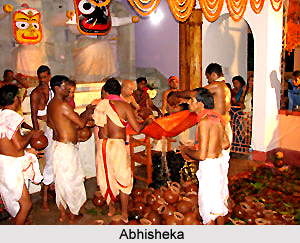 Abhisheka : Abhisheka marks the start of the chain of all those festivals of Puri related to Lord Jagannath. Abhisheka, also known as `Avhisheka` marks the coronation ceremony of the Lord, held on the full moon day in the month of `Pausha` i.e. months of December and January. Keeping in mind the time of its celebration, people also call it Pushyavisheka, meaning `coronation done in Pausha month`.
Dolayatra : Dolayatra, or the festival of colours, is celebrated from the tenth day of the bright fortnight of Falguna (March to April) till the full moon day. Just like the entire nation, residents of Puri also go gaga with the fervour of festivity. Truly it is one of the famous festivals of Puri where people abide by rituals in their true spirit. Dolagobinda or Madan Mohan is enshrined on a swing and also coloured powder or abira is put on his feet.
Chandanyatra : Starting on the 3rd day of the bright fortnight of Baisaksh Akshay Trutiya , this spectacular festival continues for twenty-one days the time period being from April to May. At the time of the festival idols of deities namely Krishan , Rama, Madan Mohan , Saraswati and Laxmi are taken out in a beautiful procession to Narendra Tank. Along with them five Shivas or Pancha Pandavas like Lokanath, Yameswar, Markandeya, Kapal Mochan and Nilakanth are brought outside. Idols of Madan Mohan, Laxmi and Saraswati are placed in a boat, nicely decorated . Rama, Krishna and all the five Shivas are placed in another boat. Cruising of the celestial gods are done in accompaniment of music and songs. Thus it is called the outer Chandan Yatra.
Snana Yatra :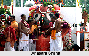 Popularly acclaimed as Snana Yatra , this counts among the popular festivals of Puri. It is held on the auspicious full moon day of Jyestha ( May- June). This is the day when the three deities along with Lord Madan Mohan and Sudarshan are taken outside. At the end of a colourful procession, they are taken to the outer enclosure of the temple. Snana Vedi is the bathing platform where they are placed to perform the holy rite of bathing accompanied by 108 pitchers of water drawn from a well near the Northern Gate.
Anasara : Anasara follows the of Snana Yatra. After the completion of holy bathe, the deities remain in the Anasar House for a period of fifteen days. At that time nobody, not even the priests or Pandas, are allowed to enter the house. It is believed that the deities are infected with fever due to exposure to prolonged bathes. At that time only a class of `Sevaks` of the temple, called Daitas are allotted the duty of revering them secretly.
Chitalagi Amavasya : It is observed on the new moon day of the month of Srabana, i.e. July. No grand rituals and festivities are associated with Chitalagi Amavasya. However numerous people assemble in the temple premises to catch a glance of the gaudy ornaments of the three idols, exhibited during the festival of bathing.
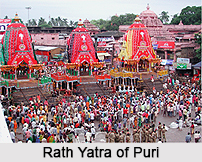
Sri Gundicha or Car festival : Every year the coastal area comes alive with the celebration of Sri Gundicha or Rath Yatra. This is one of the most admired festivals of Puri. It has worldwide fame. Millions of devotees gather in Puri to behold the grandness of this festival. Usually held on the 2nd day of the bright fortnight of Asadha, it falls in the months of June and July. On this day, the 3 deities of Jagannath, Balabhadra and Subhadra are brought out from the main temple of Lord Jagannath for public viewing. Travelling on three newly built huge chariots made up entirely of wood, they move forward to the Gundicha Temple, lying almost three km away.
Nava Kalebara : Nava Kalebara is another ritual associated with this car festival of Puri. It implies a process of renewal of body. It is believed according to the Hindu calendar, once in every twelve years, gods and goddesses discard their old frames and metamorphose into new idols.
It is a sacred ritual, feted by the illustrious temple priests. Choosing and dropping of the tree, cutting and drawing new images and most importantly transmission of the celestial spirit from the old to the new frame are some of the ritualistic functions that they need to perform with reverence.
Bahuda Yatra :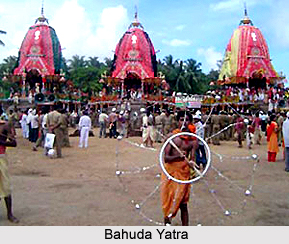 After staying in the Gundicha Temple for 7 days the idols are brought back to the main temple on the chariot. This occasion is popular as Bahuda Yatra. On the way, the chariots halt at various spots. Mausima Temple is one such stop where deities are offered with baked cakes, popularly known as Podapitha. On the auspicious day of Ekadeshi, the deities reach the Lion`s gate of the Jagannath temple. They wear beautiful gold ornaments or Suna Vesa. Special sarbat , known as Adharpana is offered to them. In the following day the deities are taken into the temple to `Ratna Vedi`. Its popular name is Niladri vije. This marks the end of the car festival.
Jhulan Yatra : The whole region decks up in new colours and vivacity, when the time of celebrating Jhulan Yatra draws near. In the true sense, Jhulan Yatra is one of the important festivals of Puri. Feted every year in the premises of `the Temple` and in several `Maths in Puri`, this festival lasts for six days. It starts from the tenth day of the dazzling fortnight of Shrabana (June-July) till the 1st day of Bhadraba (July-August). Jhulan Yatra is the occasion of joy when idols of deities like Vishnu and Laxmi are placed on a swing of `Jhulan Mandap` with full decorations. They are swung to and fro to the rhythm of beats of music and songs.
Satapuri Amabasya Festival of Puri : The month of August, known as Bhadraba in Hindu calendar, is the time to celebrate Satapuri Amabasya, one of the significant festivals of Puri.
Radhastami Festival of Puri : Radhastami Festival of Puri is a joyous occasion when devotees revere the idol of Sudarsana. It is the festival that is closely associated with Lord Krishna`s consort, Radha. On the auspicious day of Radhastami, Sudarsana circumvallates the inner area of the Temple.
Ananta Chaturdarshi Festival : In the vista of Puri festivals, Ananta Chaturdarshi Festival holds a place of special significance. Ever year in the Bhadrava month (August) people enthrall in the joyful mood of this festival. On the very day a social ceremony is observed in the Ananta Basudev temple.
Sahasra Kumbha Avisekha : It marks the celebration of consecrating thousand vessels, which begins on the eighth day of the murky fortnight in `Aswina` or October. On this auspicious day goddess Vimala along with few other goddesses are revered following the Sakta or Tantric rites. The famous Autumnal festival also commences with Sahasra Kumbha Avisekha.
Dasahara Festival :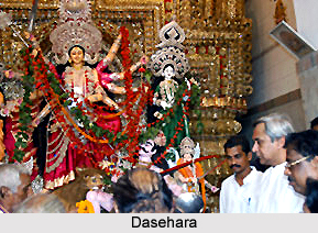 With the completion of Sahasra Kumbha Avisekha, time comes to fete the Dasahara festival with same jubilance and enthusiasm. It is the festival of worship of weapons. During this festival Duraga Madhav Puja is performed. It bears special significance in the community of conventional farmers. They are called Paikas, who once upon a time formed an integral part of martial troupes of Orissa state.
Kumar Purnima Festival : Kumar Purnima is observed in Aswini month. Innumerable festivals constitute Puri, amongst them this festival deserves special mentioning. Legend says that `Kumar` or `Kartikeya`, the good-looking son of Lord Shiva was born on this auspicious day. Later he was revered as the `God of war`. Interestingly no such ritual is observed for worshipping this God. Instead the Sun and Moon are adored by a myriad of devotees. As a key ritual, ladies take a bath for purification of their bodies. Dressing up in new clothes and offering food to the Sun god are carried on afterwards. Throughout the day they keep on fasting. During evening when the moon shines, they offer a special variety of food to the God. Only when the rituals are completed they can consume food. Music and dance form an integral part of it. Girls dance and sing raising the tempo to its fullest. Apart from singing special type of songs, they also love to play Puchi, a unique game. Women also engage themselves in playing other type of country games.
The Gajalaxmi Puja : This holy day is also feted as the birthday of Goddess Laxmi, the deity of wealth. Folk legend speaks of two sets of priests playing dice. One represents Lord Jagannath and the other goddess Laxmi. It is however not known for certain who wins or loses the game. Quite a number of people revere the Goddess in their respective homes. They keep themselves awake by playing Pasha (Chess), and a few more indoor games. If any one desires to gain wealth they should be on vigil throughout the night. It is a popular faith of the believers.
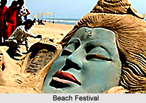 Apart from these, there are handful of festivals that are observed by all the pious residents of Puri. They include- Sayan Ekadasi , Samazik Chori, Chitalagi, Gamha, Purnima, Krishan- Lil , Magha Purnim , Bakula Amabasy, Odham Sasthi and many more. In present times, effort is being exercised to attract tourists from all over the country. Organised in the months of April and November the Puri Sahi Yatra and Beach festival captivates the tourers, who are utterly mesmerised seeing the extravaganza associated with these festivals.
Amongst the festivals of Puri quite a few can be described as
Abhisheka : Abhisheka marks the start of the chain of all those festivals of Puri related to Lord Jagannath. Abhisheka, also known as `Avhisheka` marks the coronation ceremony of the Lord, held on the full moon day in the month of `Pausha` i.e. months of December and January. Keeping in mind the time of its celebration, people also call it Pushyavisheka, meaning `coronation done in Pausha month`.
Dolayatra : Dolayatra, or the festival of colours, is celebrated from the tenth day of the bright fortnight of Falguna (March to April) till the full moon day. Just like the entire nation, residents of Puri also go gaga with the fervour of festivity. Truly it is one of the famous festivals of Puri where people abide by rituals in their true spirit. Dolagobinda or Madan Mohan is enshrined on a swing and also coloured powder or abira is put on his feet.
Chandanyatra : Starting on the 3rd day of the bright fortnight of Baisaksh Akshay Trutiya , this spectacular festival continues for twenty-one days the time period being from April to May. At the time of the festival idols of deities namely Krishan , Rama, Madan Mohan , Saraswati and Laxmi are taken out in a beautiful procession to Narendra Tank. Along with them five Shivas or Pancha Pandavas like Lokanath, Yameswar, Markandeya, Kapal Mochan and Nilakanth are brought outside. Idols of Madan Mohan, Laxmi and Saraswati are placed in a boat, nicely decorated . Rama, Krishna and all the five Shivas are placed in another boat. Cruising of the celestial gods are done in accompaniment of music and songs. Thus it is called the outer Chandan Yatra.
Snana Yatra :
Popularly acclaimed as Snana Yatra , this counts among the popular festivals of Puri. It is held on the auspicious full moon day of Jyestha ( May- June). This is the day when the three deities along with Lord Madan Mohan and Sudarshan are taken outside. At the end of a colourful procession, they are taken to the outer enclosure of the temple. Snana Vedi is the bathing platform where they are placed to perform the holy rite of bathing accompanied by 108 pitchers of water drawn from a well near the Northern Gate.
Anasara : Anasara follows the of Snana Yatra. After the completion of holy bathe, the deities remain in the Anasar House for a period of fifteen days. At that time nobody, not even the priests or Pandas, are allowed to enter the house. It is believed that the deities are infected with fever due to exposure to prolonged bathes. At that time only a class of `Sevaks` of the temple, called Daitas are allotted the duty of revering them secretly.
Chitalagi Amavasya : It is observed on the new moon day of the month of Srabana, i.e. July. No grand rituals and festivities are associated with Chitalagi Amavasya. However numerous people assemble in the temple premises to catch a glance of the gaudy ornaments of the three idols, exhibited during the festival of bathing.
Sri Gundicha or Car festival : Every year the coastal area comes alive with the celebration of Sri Gundicha or Rath Yatra. This is one of the most admired festivals of Puri. It has worldwide fame. Millions of devotees gather in Puri to behold the grandness of this festival. Usually held on the 2nd day of the bright fortnight of Asadha, it falls in the months of June and July. On this day, the 3 deities of Jagannath, Balabhadra and Subhadra are brought out from the main temple of Lord Jagannath for public viewing. Travelling on three newly built huge chariots made up entirely of wood, they move forward to the Gundicha Temple, lying almost three km away.
Nava Kalebara : Nava Kalebara is another ritual associated with this car festival of Puri. It implies a process of renewal of body. It is believed according to the Hindu calendar, once in every twelve years, gods and goddesses discard their old frames and metamorphose into new idols.
It is a sacred ritual, feted by the illustrious temple priests. Choosing and dropping of the tree, cutting and drawing new images and most importantly transmission of the celestial spirit from the old to the new frame are some of the ritualistic functions that they need to perform with reverence.
Bahuda Yatra :
After staying in the Gundicha Temple for 7 days the idols are brought back to the main temple on the chariot. This occasion is popular as Bahuda Yatra. On the way, the chariots halt at various spots. Mausima Temple is one such stop where deities are offered with baked cakes, popularly known as Podapitha. On the auspicious day of Ekadeshi, the deities reach the Lion`s gate of the Jagannath temple. They wear beautiful gold ornaments or Suna Vesa. Special sarbat , known as Adharpana is offered to them. In the following day the deities are taken into the temple to `Ratna Vedi`. Its popular name is Niladri vije. This marks the end of the car festival.
Jhulan Yatra : The whole region decks up in new colours and vivacity, when the time of celebrating Jhulan Yatra draws near. In the true sense, Jhulan Yatra is one of the important festivals of Puri. Feted every year in the premises of `the Temple` and in several `Maths in Puri`, this festival lasts for six days. It starts from the tenth day of the dazzling fortnight of Shrabana (June-July) till the 1st day of Bhadraba (July-August). Jhulan Yatra is the occasion of joy when idols of deities like Vishnu and Laxmi are placed on a swing of `Jhulan Mandap` with full decorations. They are swung to and fro to the rhythm of beats of music and songs.
Satapuri Amabasya Festival of Puri : The month of August, known as Bhadraba in Hindu calendar, is the time to celebrate Satapuri Amabasya, one of the significant festivals of Puri.
Radhastami Festival of Puri : Radhastami Festival of Puri is a joyous occasion when devotees revere the idol of Sudarsana. It is the festival that is closely associated with Lord Krishna`s consort, Radha. On the auspicious day of Radhastami, Sudarsana circumvallates the inner area of the Temple.
Ananta Chaturdarshi Festival : In the vista of Puri festivals, Ananta Chaturdarshi Festival holds a place of special significance. Ever year in the Bhadrava month (August) people enthrall in the joyful mood of this festival. On the very day a social ceremony is observed in the Ananta Basudev temple.
Sahasra Kumbha Avisekha : It marks the celebration of consecrating thousand vessels, which begins on the eighth day of the murky fortnight in `Aswina` or October. On this auspicious day goddess Vimala along with few other goddesses are revered following the Sakta or Tantric rites. The famous Autumnal festival also commences with Sahasra Kumbha Avisekha.
Dasahara Festival :
With the completion of Sahasra Kumbha Avisekha, time comes to fete the Dasahara festival with same jubilance and enthusiasm. It is the festival of worship of weapons. During this festival Duraga Madhav Puja is performed. It bears special significance in the community of conventional farmers. They are called Paikas, who once upon a time formed an integral part of martial troupes of Orissa state.
Kumar Purnima Festival : Kumar Purnima is observed in Aswini month. Innumerable festivals constitute Puri, amongst them this festival deserves special mentioning. Legend says that `Kumar` or `Kartikeya`, the good-looking son of Lord Shiva was born on this auspicious day. Later he was revered as the `God of war`. Interestingly no such ritual is observed for worshipping this God. Instead the Sun and Moon are adored by a myriad of devotees. As a key ritual, ladies take a bath for purification of their bodies. Dressing up in new clothes and offering food to the Sun god are carried on afterwards. Throughout the day they keep on fasting. During evening when the moon shines, they offer a special variety of food to the God. Only when the rituals are completed they can consume food. Music and dance form an integral part of it. Girls dance and sing raising the tempo to its fullest. Apart from singing special type of songs, they also love to play Puchi, a unique game. Women also engage themselves in playing other type of country games.
The Gajalaxmi Puja : This holy day is also feted as the birthday of Goddess Laxmi, the deity of wealth. Folk legend speaks of two sets of priests playing dice. One represents Lord Jagannath and the other goddess Laxmi. It is however not known for certain who wins or loses the game. Quite a number of people revere the Goddess in their respective homes. They keep themselves awake by playing Pasha (Chess), and a few more indoor games. If any one desires to gain wealth they should be on vigil throughout the night. It is a popular faith of the believers.
Apart from these, there are handful of festivals that are observed by all the pious residents of Puri. They include- Sayan Ekadasi , Samazik Chori, Chitalagi, Gamha, Purnima, Krishan- Lil , Magha Purnim , Bakula Amabasy, Odham Sasthi and many more. In present times, effort is being exercised to attract tourists from all over the country. Organised in the months of April and November the Puri Sahi Yatra and Beach festival captivates the tourers, who are utterly mesmerised seeing the extravaganza associated with these festivals.Tourism of Puri
 Tourism of Puri has always been popular among travel enthusiasts due to the existence of many amazing tourist places in Puri including the Jagannath Temple. One of the four celebrated religious centers of India, Puri is the abode of Lord Jagannath. According to tradition Puri was once a thickly wooded hill. Known for its historic antiquities, religious sanctuaries, architectural grandeur, seascape beauty, moderate climate and spiritual significance, this coastal state of Odisha attracts a number of visitors every year.
With a rich historic heritage dating back to 3rd Century BC, this temple town welcomes both the pilgrims and fun seekers offering its splendid beaches and temples. Recognition of the Rath Yatra at a global level, acceptance of Odissi as a classical dance form and Orissan School of architecture have helped a lot to fetch Puri, the status of an internationally known city.
Puri represents a sense of holiness with the aroma of antiquity, which attracts most of the tourists. Sanctuaries, golden beaches and glorious lakes that is visually fascinating, crafts that are colourful and vibrant and the numerous festivals etc are the principal attraction in Puri, which stimulate the rapid development of the tourism industry in Puri. Some of the tourist attractions of Puri are discussed below:
Raghurajpur : Raghurajpur is known as the artisans" village, is a living museum itself. Raghurajpur is 12km from Puri. This village is famous for Patachitra. Every household has a painter and can show some lavishly painted the age-old tradition paintings on canvas, silk and other varieties like papier mache, masks, stone idols, sculptures, wooden idols, toys and many more.
Pipili : Pipili is again a craft village for Applique work. One can find a series of shops decorated with many applique works with bright colors. The varieties are like umbrellas, lamps shades, wall cloths, table covers, sofa covers, children cloths, bed covers and many more.
 Dhauli : Dhauli is an important historical site famous for Shanti stupa and Ashokan Rock Edicts on a hillock. It is said that the famous Kalinga War was fought here during the 3rd century BC. It is also a Buddhist site and many archaeologist relics are discovered here. It is only 6 km away from Bhubaneshwar.
Konark : The famous Konark Sun Temple is situated about 40 kms northerly direction to Puri which is world famous for its magnificent architecture. There are 7 horses and 24 carved wheels which show that this has been carved to depict the Sun God.
Chilka Lake : Chilka Lake is the largest lagoon of the Asia which is about 1100 sqkm of brackish waters of Bay of Bengal. It is also famous for migrated birds such as flamingoes, pelicans, Ospreys, Ruffs and Avocets from Siberia and Persia.
Bindu Sagar Lake : Bindusagar is a small artificial lake which has a great religious importance. It is believed that the holy waters of all the sacred rivers along with nectar, wine are present within the lake. During the Rath Yatra, the deity of Lingaraj Temple is taken for ceremonial bath.
Jagannath Temple : Jagannath Temple is one of the most impressing monuments of Odisha. The temple was constructed by a famous king of Ganga Dynasty Ananta Varman Chodaganga Deva dating back to 12th century. This astounding Vaishnava temple enshrines Lord Jagannath, Devi Subhadra and Balarama. The main temple of Jagannath is an impressing and amazing structure constructed in Kalinga architecture, with a height of 65 meters placed on an elevated platform.
Jagannath Rath Yatra : The much famous Temple Chariot Festival of Lord Jagannath takes place in Puri. Thousands of visitors come to Puri to experience this eye catching scene that is viewed once in a year.
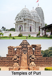 Temples of Puri : The land of temples, Puri represents religious architecture. Jagannath temple, representing the saga of religious and sculptural architecture enhances the tourist quotient.
•Gundicha Temple
•Astachandi Temple
•Panchatirtha Temple
•Loknath Temple
•Dasavatara Temple
•The Temple of Seven Mother Goddesses
•Mausima Temple
•Chhatia Jagannath Temple
•Parasurameswara Mandir
•Raja Rani Mandir
•Mukteshwara Temple
•Lingaraj Temple
•Brahmeswara Temple
Recently updated articles in States of India
History of Thissur District
Early History of Thissur District explains flourishing of the port cities. Now these port cities are transformed into archaeological sites.
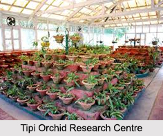
Tippi Orchid Research Centre, Arunachal Pradesh
Tippi Orchid Research Centre in Arunachal Pradesh is renowned for its rich collection of exotic and endangered orchids. Surrounded by lush rainforest...
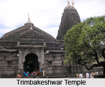
Tourism in Nashik District
Pilgrimage tourism in Nashik district involves visiting the various places of Hindu and Jain worship located here. Some of the holiest sites for Hind...
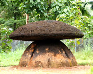
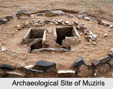
Mangadu, Kerala
Mangadu in Kerala’s Kollam district is a significant megalithic site known for its urn burials, cist burials, menhirs, and stone circles. Excavations...
Devaswom
History of Devaswom is not very ancient and can be dated back to late seventeenth century.
Related articles in States of India

East Indian States
East Indian States comprises of Bihar, Jharkhand, West Bengal, Odisha and also the Union Territory of Andaman and Nicobar Islands. It defines the cult...

Purnia District in Bihar
Purnia District is located in Bihar and extends from River Ganga to Nepal. The district has a rich Hindu history and glorious past.

Hooghly district
Hooghly District along the bank of the river Hooghly is one of the principal trading ports of West Bengal.

Geography Of Chittoor District
Geography of Chittoor district is spread along the topography of the land which is divided into two natural divisions; Chittoor has a dry and healthy...

Districts of West Bihar
Districts of West Bihar is comprised of medieval monuments that were built by the different governors of Mughal era.