 According to the historical records the district of Puri, it existed since the prehistoric Pleistocene times but unfortunately the historical records of that time regarding the formation of district is not yet found. Therefore the historical significance and the antiquity of the district Puri is limited to the archaeological excavations and the stone tools discovered in the adjacent regions.
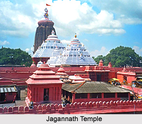
Though the history and formation of the district Puri is known from the archaeological excavated facts, however the reason behind the nomenclature of Puri district is still in utter confusion. The District has been named after its head quartes town, Puri.According to Cunningham, the eminent historians the ancient name of this town was Charitra mentioned by the Chinese piligrim Hiuen Tsang as Che-li-ta-lo. Though the town Puri was not significantly associated with the political history of Orissa, it attained spotlight with the king Chodagangadeva and became an important seat of the Vaishnav cult in Orissa, when he established the temple of Purusottama Jagannath and installed the images of the deities. Thereafter, it became famous as the abode of Purushottamadeva and was popularly called Purusottam Kshetra. But it is still in obscurity that how the Purusottam Kshetra came to be transformed into a new name of Puri district
The manuscripts of the contemporary people, also serve as the chief sources of the historical records of Puri district. The Nagari Plate of Anangabhimadeva III of the Saka year 1151-52 i.e., 1229-30 A.D., the present district of Puri is mentioned as Purusottam Kshetra. The Mughal, the Maratha as well as the early British rulers in their official records used Purusottam Kshetra in the form of Purusottama Chhatar or only in the form Chhatar. Even in Yoginitantra and Kalikapurana the city of Puri is referred to as Purusottam. Puri region was also known as Utkal. However the historical records are not clear enough to decipher the actual fact behind the identification of Purusottam Kshetra as Puri. Though the indigenous historical records relate the name of the district as Purusottam Chhatar, in the British records of 19th century, the district is mentioned as Pooree. However presently the name "Puri" is acknowledged.
When the Mughals occupied Orissa and considered it for the revenue administration, they divided the entire tract of Orissa into three circars, namely Jaleswar, Bhadrak and Kataka each of which under the Muhgal jurisdiction was subdivided into Bishis. As the history of Puri suggests, Puri was a part of the Kataka Circar. Again when the Marathas became the sole authority of the Orissa province, they brought some alterations in the revenue divisions of the province. Orissa, which was then extending from the river Suvarnarekha in the North to the lake Chilika in the South, was fragmented into five Chakalas viz. Pipli, Kataka, Soro, Balasore. 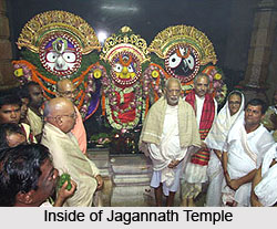 As far the historical records of Puri are concerned, the major section of the present district of Puri comprised the Chakalas of Pipli. During the arrival of the British in Orissa, the entire province has undergone another phase of subdivision of the revenue districts. At that time the revenue districts of Orissa was divided into Northern and southern subdivision. As the raja of Barabati revolted in 1804 he was arrested and was placed in confinement in the Fort of Barabati at Cuttack. In 1807 he was allowed to live at Balisahi in the town of Puri and function as superintendent of the temple of Jagannath. Moreover Puri survived as the capital of Orissa province and the headquarter of the collector till 1816. The proposal has been approached by the Government officials to transfer the capital from Puri to Jajpur, but it was not however sanctioned. From 1813 to 1819 a joint Magistrate was appointed at Puri with the jurisdiction over the Thanas of Pipli, Gop, Hariharpur and Kiran. Following the historical records of Puri, during the British supremacy in India, Puri served as the key center to carry out all the administrative in Orissa.
Finally on 23rd October 1828, Orissa province was divided into three districts, namely Balasore, Cuttack and Jagannath, later known as Puri. In 1912, the new province of Orissa and Bihar was formed and subsequently after Orissa became a separate administrative state, the British Government reorganized the district speaking Oriya and decided to merge them with the newly formed province of Orissa. Consequently after incorporation with Orissa on 1st January 1948 of the feudatory states of Nayagarh, Despalla, Khandapara and Ranapur with a total area of 3941 1st km. a separate Sub-Division comprising these ex-states was annexed with Puri District with headquarters at Nayagarh. However the district of Puri has undergone several changes in the year of 1959 during the subdivision of Bhubaneswar. The present Puri district is a Puri District comprises of Puri Sadar Sub-Division only.


