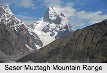
 Saser Muztagh Mountain Range is in the neighbourhood of the borderline between Pakistan and India. Saser Muztagh Mountain Range is surrounded by the south, east and north-east with the Shyok River, Ladakh district, India. On the west, Saser Muztagh Mountain Range is separated from the neighbouring Kailas Mountains by the Nubra Valley. The Sasser Pass (Saser La) marks the border line between it and the Rimo Muztagh to the north. The Ladakh Range stands to the south of the Saser Muztagh, across the Shyok River.
Location of Saser Muztagh Mountain Range
Saser Muztagh Mountain Range is situated in the Karakoram Range of the Kashmir region of India. The Shyok River changes the direction sharply in the region of the south-east corner of the Karakoram Range.
Glaciers and Peaks of Saser Muztagh Mountain Range
There are a number of glaciers in the area of Saser Muztagh Mountain Range namely, North and South Shukpa Kunchang Glaciers, the Sakang Glacier and the Chamshen Glacier. There are a number of peaks in the region of Saser Muztagh Mountain Range namely, Saser Kangri I at a height of 7,672 meters. It is the highest mountain peak among the all five brothers and is ranked 35th in the world. Saser Kangri II at a height of 7513 meters and Saser Kangri III at a height of 7495 meters above the sea level are the two other peaks in this mountain range. These three peaks have a mountain prominence (it is a measure of vertical departure between mountains) over 500 meters (1524 feet).
There is presently a little climbing and investigative actions going on in the Saser Muztagh Mountain Range, with the exception of special invasions by the Indian military.
This article is a stub. You can enrich by adding more information to it. Send your Write Up to content@indianetzone.com.


