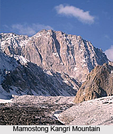
 Mamostong Kangri is the highest mountain range in the remote sub range of the Rimo Muztagh which is a sub range of the Karakoram Range in India near its border with China. The name of the mountain is also spelled as `Mamostang Kangri`. Mamostong Kangri is the forty eighth highest independent peak in the world. On the slopes of the Mamostong Kangri there are a number of glaciers namely, the South Chong Kumdan Glacier, Kichik Kumdan (Thangman), Mamostong, and South Terong Glaciers. The parent mountain of Mamostong Kangri is Gasherbrum I.
Location of Mamostong Kangri Mountain
It is located in the Kashmir state of India. The mountain is positioned in the southeast direction of the snout of the Siachen Glacier. The peak is situated at a height of 7,516 meters (24,659 feet) above mean sea level. Geographically, the mountain is located between 35 degree 08`27North latitude and 77 degree 34`39 East longitude. The mountain prominence (it is a measure of vertical separation between mountains) of Mamostong Kangri is 1,083 meters.
Exploration of Mamostong Kangri Mountain
The first European exploration of Mamostong Kangri was made in the year 1907. The peak was first scaled in the year 1984 by an Indo-Japanese expedition, via the Northeast Ridge. Mamostong Kangri can be approached along the Mamostong glacier or along the Thangman glacier.


