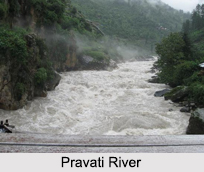
The Parvati River rises from the Man Talai Glacier below the Pin Parbati Pass. This pass connects the fertile and lush Parvati valley on the Kullu side with the Pin valley on the Spiti side. Situated at an elevation of 5,319 metres, the pass has now become a popular trekking route.
The river flows in a gradual curve from the north-northwest to the west-southwest past the pilgrimage centre of Manikaran. The Parvati River flows to Lahaul across the Sara Umga La Pass, then to Spiti across the Pin Parbati Pass and moves on to the recently discovered Debsa Pass. The river has fine first-growth forests in its upper reaches which are being degraded as a consequence of development of its vast hydro-electric potential. The Parvati River also has geothermal springs on the banks of the river at Manikaran and Khirganga.
This article is a stub. You can enrich by adding more information to it. Send your Write Up to content@indianetzone.com
(Last Updated on : 08-09-2018)
|
|
|
|
|
|
|
Recently Updated Articles in Geography of India
|
|
|
• | History of Indian Forests History of Indian Forests reveals a constant process of exploitation and preservation. The history of Indian forests is rather intimately associated with the political history of the state.
| | • | Forests in Ancient India FForests in Ancient India and forestry traditions have been wonderfully documented in the religious literary texts. Both protective as well as productive aspects of Forests in Ancient India can be found in the various traditional literary texts like Vedas, Puranas and the great Epics.ests in Ancient India and forestry traditions have been wonderfully documented in the religious literary texts. Both protective as well as productive aspects of Forests in Ancient India can be found in the various traditional literary texts like Vedas, Puranas and the great Epics.
| | • | Koyna Dam Koyna Dam is the largest dam in Maharashtra. This dam has been constructed in the Koyna Nagar nestled in the Western Ghats between Chiplun and Karad. It originates from Mahabaleshwar, a hill station in the Sahyadris Mountain Range.
| | • | Jindhagada Peak Jindhagada Peak is the tallest peak of Eastern Ghats Mountain Range.
| | • | Eastern Coastal Plains The Eastern Coastal plains extend amongst the sea coast from Subarnarekha River to Kanyakumari and Eastern Ghats. The Deltas of Mahanadi, Godavari, Kaveri and Krishna River traverse these plains. The eastern coast has several sub categories in it as well.
| | |
|
|
|
|