 Malaprabha River is an Indian river which flows through the Karnataka state of India. It is one of the confluences of the Krishna River. After rising in the Western Ghats the river joins Krishna River at Kudalasangama in Bagalkot district. There is a dam known as Renukasagar built on this river. There are various temples situated on the banks of this river. These temples serve as religious spots which are frequented by a number of tourists and pilgrims from varied distant places.
Origin and Flowing of Malaprabha River
The river originates in the Western Ghats at an elevation of 792 metres above the mean sea level. This part of the Western Ghats is located in the west of Jamboti village at a distance of sixteen kilometers in Khanapur taluk in the Belgaum district of Karnataka After flowing in the east and then in the northeast direction, the river finally joins the Krishna River at Kudala Sangama in Bagalkot district of Karnataka at a height of 488 meters above mean sea level. The river flows for three hundred and four kilometers before merging with the Krishna River. The river has a total catchment area of nearly 11,549 square kilometers.
 Tributaries of Malaprabha River
Bennihalla, Hirehalla and Tuparihalla are the main tributaries of Malaprabha River.
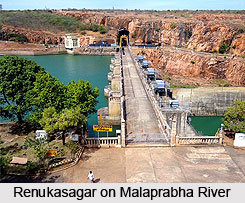
Economical Significance of Malaprabha River
A dam is built across this river near Munavalli in Belgaum district. The dam is known as Renukasagar. The reservoir of this dam is created with a catchment area of 11549 km³. This reservoir is said to irrigate more than two thousand square kilometers of agricultural land.
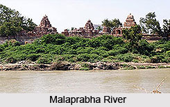
Religious Significance of Malaprabha River
The river has religious significance owing to the presence of various ancient temples on its bank. An ancient temple dedicated to Shree Mauli Devi is situated at the origin of this river. Another temple dedicated to deity Yellamma is nestled on a nearby hill. This temple is visited by thousands of devotees. Aihole, Pattadakal and Badami are some of the other temples located on the banks of the Malaprabha River. These temples have been declared as World Heritage sites by UNESCO (United Nations Educational, Scientific and Cultural Organization).


