Home > Indian History > Geography of India > Natural resources of Lohardanga District
Natural resources of Lohardanga District
The natural resources of the Lohardanga district are immense which has enhanced its socio economic scenario.

Share this Article:

The immense natural resources of the Lohardanga district have further added to the economic status of the district. There are various natural resources, which can be mentioned in the following grounds:

Natural resources of Lohardanga District Minerals:
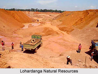
The laterite and bauxite are the main mineral resources of this district. In addition to this china clay is also found here. In the North west of Lohardaga there is a mountain part that is spread like a wall. This is a vast godown of bauxite. In addition to the petty contractors, two main aluminum companies` extract bauxite from this area. It has been said that this bauxite is spread in this area for 60-70 years.

Soil & River:
The quality of soil and river in this district is very unusual. Major part of the area is covered with red laterite acidic soil. Morum, forest and stone, etc generally cover the upland. The Major rivers of this district are koyal, sankh, Nandani, sahi, fulshar. These rivers are generally rainy rivers.

Flora & Fauna:
One important part of the district is, it is covered with forest. The district has about 27% of forest area while other areas are also covered with lush green forest. Important forest products are Saal seeds, Kokun, Lac, Tendu leaves, Karanj, Chiraunji etc. The major trees can be named as Sal Bija, Gamhar, Kathal, Jamun, Mango, Bamboo, Neem etc.

Industry:
In Lohardaga district, small scale industries are there which are mainly based on agriculture, forest, mining, machinery fabrication, leather goods, electric, printing press, Kalin Industry, Road transportation etc. Many labors are engaged in these works and maintain their livelihood based on this work. Average annual income of each entrepreneur is quite good and is enough to maintain the family. Bauxite is extracted from this area and it is done by the two major aluminum companies other than some petty contractors.

Agriculture and irrigation:
Mineral wealth is found everywhere in the district. But the farmers here are mainly depended on agriculture. Almost 79% of the total work force of the district depends on agriculture and so related activities. Due to erratic rain, obscene of irrigational facilities, the farmers are not able to grow enough to supplement their food. And this is why they keep on migrating to other places.

The district comes under the influence of three river systems namely the Damodar or Ganga basin, North Koel and South Koel. The district has a surface flow of 481 MCM that is still untapped. Most of the nallahs have enough flow during the monsoon but the flow is considerably reduced in bean periods and these are not enough storage even for individual pump sets.


Share this Article:

Related Articles

More Articles in Geography of India


Geography of Uttar Pradesh
The fourth largest State in India UP is located in the Northern part of India whose area is 2,36,286 sq Kms.
Geography of Maharashtra
Covering an area of 308,000 sq. km, Maharashtra, the third largest state in India.
Geography of Kerala
Geography of Kerala includes plains, hills, valleys and coasts. With the Arabian Sea in the west, the Western Ghats in the east and networked by several rivers, Kerala enjoys diverse geographical features.
Geography of West Bengal
The geography of West Bengal is unique with high peaks of the Himalayan range in the north, the Bay of Bengal in the south and the remaining region is covered with both plains and plateaus.
Geography of Jharkhand
Geography of Jharkhand is comprised of the rich mineral resources and the highly agricultural prospect in this state.
Geography of Sikkim
Geography of Sikkim is characterised by a vast array of magnificent hillock that extends from one corner of the state to the other.
Geography of Meghalaya
The suitable climate, highland plateaus, rivers and the flora and fauna together forms the geography of Meghalaya.
Geography of Mizoram
Mizoram is surrounded by hills, valleys, rivers, waterfalls and lakes. The hills range from 1000 meters to 2000 meters. Rivers, lakes and waterfalls also play major role in forming the land of Mizoram.
Geography of Jammu & Kashmir
Jammu and Kashmir is encompassed by valleys. Some of the dominant valleys of the state are Kashmir Valley, Tawi Valley, Chenab Valley, Poonch Valley, Sind Valley and Lidder Valley etc. Jhelum River is the only major Himalayan River which flows through the Kashmir valley. Indus, Tawi, Ravi and Chenab Rivers are the major ones flowing through the region.
Geography of Daman and Diu
Daman and Diu is situated on the west coast of India and are the smallest union territories of India.
Geography of Goa
Geography of Goa occupies a prime location along the Konkan coastal belt on the western coast of India. The state is bordered by Maharashtra in the north and Karnataka in the south. The Western Ghats in the east contribute to the flora and fauna of Goa.
Geography of Arunachal Pradesh
Geography of Arunachal Pradesh reveals that it is a hilly tract nestled in the foot of Himalayas.
Geography of Kutch
Geography of Kutch District is covering an area of 45,612 km. Kutch District is the largest district in the state of Gujarat.
Geography of Ladakh
Geography of Ladakh mainly comprises the huge Karakoram Range with long stretch of cold desert which mark the region separately from the rest of the states of Indian subcontinent. Surrounded with the mountain ranges from all corners this small region separates Indian subcontinent from rest of the Asian continent.
Geography of Rajasthan
Geography of Rajasthan defines the dry topography with arid climate of the western mountain region.
Geography of Tamil Nadu
The Indian state of Tamil Nadu is located in the Northern hemisphere in the hot zone.