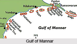
The Gulf of Mannar, a large shallow bay is located on the southeastern tip of India and is extended till the west coast of Srilanka. It has earned the distinction of being the first marine biosphere reserve in the South and Southeast Asia region. The Gulf of Mannar is separated from the Palk Strait by an array of low islands and reefs known as Ramas Bridge also called Adam Bridge. It spreads from Tuticorin to Rameshwaram Island for about 140 km. along the coastline of the Gulf of Mannar, there are nearly twenty one islands which are classified into four major groups-Tuticorin, Mandapam, Keezahakarai and Vembar. The Tuticorin Junction Railway station is the nearest railway station and the Madurai Airport at a distance of 150 km. Tuticorin is the nearest airport. The Tambaraparani from the coast of India and the Aruvi Aru from the Srilankan coast empties into the Gulf of Mannar. The chief ports on the Gulf of Mannar are the Thoothukudi in Tamil Nadu and Colombo in Srilanka.
This region is one of the richest coastal regions in Asia and is the habitat of more than 3,000 species of flora and fauna. The region is bestowed with variety of marine ecosystems, which includes mangroves, sea grass, seaweeds and coral reefs. In fact, one hundred and seventeen kinds of hard coral species have been found here. The Gulf also shelters some of the endangered species like dolphins, dugongs, whales and sea cucumbers.
For the purpose of conservation, twenty-one islets lying between Thoothukudi and Dhanushkodi of Tamil Nadu were declared as the Gulf of Mannar Marine National Park in 1986 and the buffer zone was declared as a Biosphere Reserve in 1989. The Marine National Park and the Biosphere Reserve is considered to have the world`s richest marine biological resources.


