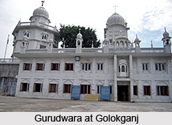
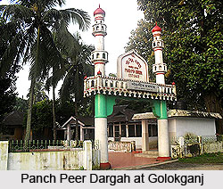
 Golokganj is a small census town in Dhubri district of the north-eastern state of India, Assam. The district headquarters is in the town of Dhubri, which is in the north-west of Golokganj at a distance of 16 km. The nearest railway station is the Golokganj Rail Station. The nearby towns are Gauripur and Dhubri where the Panch Peer Dargah and the Gurudwara of Guru Teg Bahadur are located. Golokganj is one of the historical places of Dhubri district.
Demographics
As per the 2011 India census report, Golokganj had a small population of 8,244 inhabitants of which 4,276 are males while 3,968 are females. Thus males constitute 54% of the population and females constitute 46% of the population. In Golokganj, 10.31% of the population is less than 6 years of age. Golokganj has an average literacy rate of 79.75%. This rate is higher than the nationwide average literacy rate, which is 59.5%. The male literacy rate is 85.46% and the female literacy rate is 73.63%.
Geography
Golokganj is located at an average elevation of 45 m (148 ft). Golokganj is situated 20 km from the district headquarters. Golokganj is situated on the east bank of Gangadhar River and the Indo-Bangladesh border is almost 5 km. away from heart of the place.
 The Brahmaputra divides the district into two parts. Tributaries of the Brahmaputra such as Gangadhar, Gaurang, Tipkai, Champamoti in the north and Jinjiram, Jinari and Kaloo in the south are all major contributors of floods in the area. Golokganj is the prime commercial place of its adjacent towns and villages.
Golokganj Railway Station
There is an old Railway-cum-Road bridge (unused) constructed by the British government in 1901 under the inspection of British Engineers. Golokganj railway station is situated in the heart of Golokganj town which was constructed before the East Bengal Partition of 1905 by the British. A newly resumed railway connection is constructed from Guwahati to West Bengal via this Golokganj town.
With the partition of India in 1947, railways in Assam got de-linked from that of the rest of India. Indian Railway took up the Assam Link Project in 1948 to build a metre gauge rail link between Fakiragram and Kishanganj. Fakiragram was connected to the Indian railway system in 1950.
Up to the sixties there was a railway link from Cooch Behar to Dhubri via Golokganj. It was then known as the Assam Line Railway Service. It also connected East Pakistan, even after partition. However, collapse of the rail-cum-road bridge over the Gadadhar in the seventies ended that link. The bridge has been rebuilt and the track laid again as broad gauge, entirely through Indian Territory. The line became operable in 2012.


