


 Buldhana district, with an area of 9,680 sq km is positioned in the Amravati division of the state of Maharashtra in western India. The district lies at a distance of around 500 km from the state capital, Mumbai. The place is widely known for being home to the world's largest hyper-velocity meteorite impact crater in basaltic rock, the Lonar crater. The district consists of five subdivisions, namely Buldhana, Mehkar, Khamgaon, Malkapur, and Jalgaon-Jamod. There are thirteen talukas- Buldhana, Chikhli, Deulgaon Raja, Malkapur, Motala, Nandura, Mehkar, Sindkhed Raja, Lonar, Khamgaon, Shegaon, Jalgaon Jamod and Sangrampur. Buldhana is believed to have been a part of the kingdom of Vidharaba mentioned in the Mahabharata. Since then, it has been under the rule of a number of different dynasties before it fell into the hands of the East India Company. Buldhana district, with an area of 9,680 sq km is positioned in the Amravati division of the state of Maharashtra in western India. The district lies at a distance of around 500 km from the state capital, Mumbai. The place is widely known for being home to the world's largest hyper-velocity meteorite impact crater in basaltic rock, the Lonar crater. The district consists of five subdivisions, namely Buldhana, Mehkar, Khamgaon, Malkapur, and Jalgaon-Jamod. There are thirteen talukas- Buldhana, Chikhli, Deulgaon Raja, Malkapur, Motala, Nandura, Mehkar, Sindkhed Raja, Lonar, Khamgaon, Shegaon, Jalgaon Jamod and Sangrampur. Buldhana is believed to have been a part of the kingdom of Vidharaba mentioned in the Mahabharata. Since then, it has been under the rule of a number of different dynasties before it fell into the hands of the East India Company.
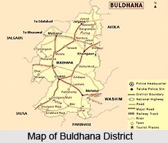
Location of Buldhana District Buldhana district is located in the central portion of the state of Maharashtra. Akola, Jalgaon, Jalna, Parbhani districts are the adjoining districts to the East, West and South respectively. Nemad district of Madhya Pradesh lies to the North. The district of Buldhana lies between the North latitudes of 19 degrees 51 minutes and 21 degrees 17 minutes and east longitudes of 75 degrees 57 minutes and 76 degrees 49 minutes. The district is bounded by the state of Madhya Pradesh on the north, the Akola district and the Washim district in the east, the Parbhani and the Jalna districts to the south, and to the west lie the Jalna and the Jalgaon districts. The district Head Quarters is at Buldhana which is connected to all thirteen talukas of the district by state highway. The state capital of Mumbai is 450 km to the west and is connected to Buldhana by road. History of Buldhana District 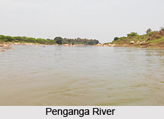 It is believed that Buldhana district, along with the rest of the erstwhile Berar province, was part of the legendary kingdom of Vidarbha that finds mention in the Mahabharata. This district also constituted a part of the Mauryan Empire during the reign of Ashoka(272 to 231 BCE). The province of Berar later came under the regulation of the Satavahana dynasty (2nd century BCE-2nd century CE), the Vakataka dynasty (3rd to 6th centuries), the Chalukya dynasty (6th to 8th centuries), the Rashtrakuta dynasty (8th to 10th centuries), and the Chalukyas again (10th to 12th centuries), and finally the dynasty of the Yadavas of Devagiri (late 12th to early 14th centuries). A period of Muslim rule began in the district when Ala ud din Khilji, Sultan of Delhi, occupied the area in the early 14th century. The district was part of the Bahmani Sultanate, which became separate from the Delhi Sultanate in the middle of the 14th century. At the end of the 15th century, the Bahmani Sultanate broke up into smaller sultanates, and in 1572 Buldhana district along with the rest of Berar became part of the Nizam Shahi sultanate, based at Ahmednagar. The Nizam Shahis surrendered Berar to the Mughal dynasty in 1595. As Mughal rule began to proliferate at the start of the 18th century, Asaf Jah I, the Nizam of Hyderabad took possession of the southern provinces of the empire (including Berar) in 1724, forming an independent state. In 1853, the Buldhana district together with the rest of Berar came under the administration of the British East India Company. Berar was divided into East and West Berar with Buldhana district being included in West Berar. It is believed that Buldhana district, along with the rest of the erstwhile Berar province, was part of the legendary kingdom of Vidarbha that finds mention in the Mahabharata. This district also constituted a part of the Mauryan Empire during the reign of Ashoka(272 to 231 BCE). The province of Berar later came under the regulation of the Satavahana dynasty (2nd century BCE-2nd century CE), the Vakataka dynasty (3rd to 6th centuries), the Chalukya dynasty (6th to 8th centuries), the Rashtrakuta dynasty (8th to 10th centuries), and the Chalukyas again (10th to 12th centuries), and finally the dynasty of the Yadavas of Devagiri (late 12th to early 14th centuries). A period of Muslim rule began in the district when Ala ud din Khilji, Sultan of Delhi, occupied the area in the early 14th century. The district was part of the Bahmani Sultanate, which became separate from the Delhi Sultanate in the middle of the 14th century. At the end of the 15th century, the Bahmani Sultanate broke up into smaller sultanates, and in 1572 Buldhana district along with the rest of Berar became part of the Nizam Shahi sultanate, based at Ahmednagar. The Nizam Shahis surrendered Berar to the Mughal dynasty in 1595. As Mughal rule began to proliferate at the start of the 18th century, Asaf Jah I, the Nizam of Hyderabad took possession of the southern provinces of the empire (including Berar) in 1724, forming an independent state. In 1853, the Buldhana district together with the rest of Berar came under the administration of the British East India Company. Berar was divided into East and West Berar with Buldhana district being included in West Berar.
Geography of Budhana District The Buldhana district experiences a tropical type of climate. It lies in the Tapti River and Godavari River basins. Purna River is a tributary of the Tapti River while Penganga River and Kadakpurna Riverare tributaries of Godavari River. The main crops grown in the district are cotton, jowar, oilseeds, soyabeans, sunflower and groundnut. The district has many minor and medium sized irrigation projects. The important ones are Nalganga and Vaan. The foremost industrial areas are at Khamgoan and Malkapur and comparatively smaller industrial areas at Chikhli, Buldhana, Dasarkhed, Deoulgaonraja, Mehkar, Sangrampur and Lonar. The railway stations in and around the Buldhana district are Khamkhed, Malkapur, Wadoda, Chandur, Biswa, Nandura, Kumgaon, Burti, Jalamb Junction, Khamgaon, Shegaon, and Nagzari. The district is connected to other places by a network of roads. The airport nearest to the district is in Aurangabad, which is at a distance of around 150 km. 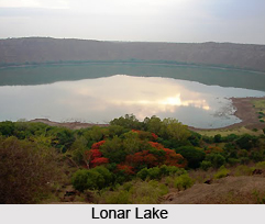
Administration of Buldhana District District Collector is the head of District Administration in Buldhana. One Additional District Magistrate assists him with eight deputy collectors to run the administrative machinery. Five Sub Divisional Officers work at the division level to distribute power at the local level. There are thirteen Tehsil headquarters assigned to the five Sub Divisions. Each one has a Tehsildar as the administrative officer. The entire department of a Tehsildar works in accordance with the land record system to serve the farmers and land holders. Tehsils are divided into circles and out of this a group of 3-4 circles are handled by the Naib Tehsildar. They enjoy all the powers of a Tehsildar for their assigned circles. Demography of Buldhana district Buldhana District has a population of 2,232,480 of which 1,144,314 are males and 1,082,014 are females (as per the 2001 census). The literacy rate is around 76.14 percent, which is considerably higher than the national average literacy rate Culture of Buldhana district Folk arts and crafts abound in the district, one of the foremost aspects of the culture of a district. The folk arts prevalent in the district are Bhajan, Keertan and Gondhal. A fair is held every year in the district on the occasion of Ram Navami. Tourism in Buldhana District There are a number of places of tourist interest located in the district. The places to visit in this district are Lonar (famous for the Lonar Crater, Lonar Lake and Lonar Sanctuary), Ajanta caves, Sindkhed Raja (birth place of Veer Mata Jijabai, mother of Chatrapati Shivaji), Chikhli (Temple of Shri Renuka Devi), Shegaon, Mehkar, Deulgaon Raja, Chikhli, Malegaon, the Dayanganga Sanctuary, the Ambabarva Sanctuary and Nandura (which harbours the world's biggest idol of Lord Hanuman). |
| |||


Buldhana District
| Buldhana district is located in the state of Maharashtra in the western part of India. Buldhana district is believed to have been part of the legendary kingdom of Vidarbha mentioned in the Mahabharata. |
| ||||||||||||||||||||||||||||

