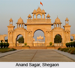
 Shegaon has acquired fame as a pilgrimage center because of Shri Sant Gajanan Maharaj. In the city there are so many institutes, temples and trusts are named on Sant Gajanan Maharaj.
Geography
Shegaon is located at 20.78 33° N lattitude 76.68 33° E Longitude . It has an average elevation of 275 metres (905 feet). Shegaon is located around 550 km east of the Mumbai city and 300 km west from Nagpur city. Shegaon`s maximum temperature during summer is 40°C and in winter it is 19°C.
Transport
By Air: Nearest airport are Akola, Aurangabad and Nagpur.
By Rail: Shegaon is a station on the Mumbai-Calcutta route of Central Railway.
By Road: Shegaon is well connected with all its neighbouring cities.
Division
Shegaon is a municipality in the Khamgaon Sub-Division of Buldhana district, along with Khamgaon tehsil.Shegaon tehsil has an area of 436 square km and consists of 95 villages has a population of around 125,000.
Demographics
 As per 2001Census of India,Shegaon had a population of 52,418. Males constitute 52% and females 48% of the population. 14% of the population is under 6 years of age.
Shegaon has an average literacy rate of 73%, higher than the national average of 59.5%: male literacy is 78%, and female literacy is 66%.
As per 2001Census of India,Shegaon had a population of 52,418. Males constitute 52% and females 48% of the population. 14% of the population is under 6 years of age.
Shegaon has an average literacy rate of 73%, higher than the national average of 59.5%: male literacy is 78%, and female literacy is 66%.
Festivals
Ram Navami, Magh Vadya Saptami (seventh lunar day in Magh month) and Rishi Panchami (one day after Ganesh Chaturthi) are important days in Shegaon. Every Thursday there is a procession and the entire Shegaon turns up for the palanquin darshan. Sansthan horses and Elephants are presently in service to the Lord.
Dharma Bhaskar Sant Pachalegaonkar Maharaj math is the nearest holy place of the Shegaon.
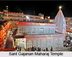
Shegaon is famous as a pilgrimage center because Shri Sant GajanaMaharaj lived there. Hindus consider Gajanan Maharaj as a saint with miraculous powers. The origins of Shri Sant Gajanan Maharaj are untraceable in history. Shri Sant Gajanan Maharaj took "Samadhi" at Shegaon. Shri Sant Gajanan Maharaj Temple is built on the Samadhi of Gajanan Maharaj at Shegaon. Sant Gajanan Maharaj Sansthan is the biggest temple trust in the Vidarbha region and is so called as "Pandharpurof Vidarbha". It attracts pilgrims from all over Maharashtra.


