Home > Travel > States of India > Balaghat District
Balaghat District
Balaghat District in Madhya Pradesh was formed during the years 1967-1973. Balaghat District in the map of Madhya Pradesh looks like a flying bird.

Share this Article:

Balaghat District, Madhya PradeshBalaghat District in Madhya Pradesh looks like a flying bird and is situated in southern part of Jabalpur division. It occupies the southeastern region of the Satpura Mountain Range and Upper Wainganga River Valley.

History of Balaghat District
Balaghat District was constituted during the years 1967-73 by amalgamation of parts of the Bhandara District, Mandla District and Seoni districts. The headquarter of the district was originally called "Burha" or "Boora". Later, however, this name fell into disuse and was replaced by "Balaghat", which was originally the name of the district only. The Wainganga River is the most important river of the district.

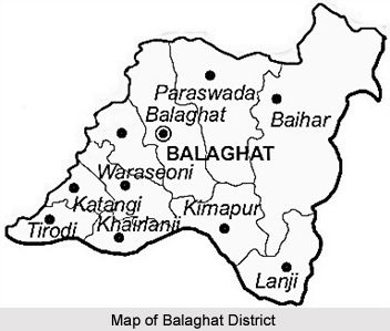
Geography of Balaghat District
Balaghat district of Madhya Pradesh spans over a degree from 21.19 degrees to 22.24 degrees North and 79.31 degrees to 81.3 degrees east. The total area of the district is 9245 square kilometres. The Wainganga River separates the district from Seoni while the Bawanthadi River and Bagh River define the inter-state boundary.

The District is very rich in forest wealth. Around 52% of the area is covered with forest. Teak, Sal, Bamboo and Saja are the main trees. Almost 25 years ago, the district was nicknamed as "Hunters Paradise". District is still proud of its varied fauna consisting of Royal Bengal Tiger, Leopard, Bear, Nilgai, deer & bison on one side and birds like Peacock, Red Bulbul and Koyal on the other.

Balaghat district occupies a pride place on the mineral map of India. About 80 percent of the Manganese production of the country comes from Balaghat. The recent discovery of Copper deposit at Malajkhand is regarded as the largest in the country. Over and above this Bauxite, Kyanite and Limestone are the other main minerals of the district.

Demography of Balaghat District
In 2011, Population Census revealed that Balaghat had population of 1,701,156 of which male and female were 841,794 and 859,362 respectively. Balaghat District population constituted 2.34 percent of total population of Madhya Pradesh. The average literacy rate of Balaghat in 2011 was 78.29 compared to 68.72 of 2001.The male and female literacy was 87.13 and 69.71 respectively.

Tourism of Balaghat District
Some of the popular tourist spots of Balaghat District are Part of Kanha National Park, Lanji Fort and Temple, Nahlesara Dam, Rampaily Temple and Gomji-Somji Temple.


Share this Article:

Related Articles

More Articles in States of India


East Indian States
East Indian States comprises of Bihar, Jharkhand, West Bengal, Odisha and also the Union Territory of Andaman and Nicobar Islands. It defines the cultural heritage, rich historical background and the linguistic unity.
Erode District
Erode District is one of the districts in the state of Tamil Nadu. The district of Erode is having a land-locked area with no sea coast.
Purnia District in Bihar
Purnia District is located in Bihar and extends from River Ganga to Nepal. The district has a rich Hindu history and glorious past.
South Delhi District
South Delhi District is the third largest district of Delhi as far as its area is concerned. South Delhi District is known for its economic, historical, cultural and social significance.
North Indian States
North Indian States formed the cultural and religious unity in spite of having many foreign invasion and the political disturbances from the early era till the British gained supremacy in Indian sub continent.
Kendujhar District
Kendujhar District, spread over an area of 8,240 sq kms, is as varied as the whole of Orissa with waterfalls roaring gorges, mountains and minerals. The manifold expressions of nature in Kendujhar District are considered as unique.
Hooghly district
Hooghly District along the bank of the river Hooghly is one of the principal trading ports of West Bengal.
Districts of South Tamil Nadu
Districts of South Tamil Nadu consist of many tourism destinations like archaeological sites and the history of Pandyas and Cholas. Considering their proximity to the sea, many districts also boast of serene beaches and coastal beauty.
Flora of Arunachal Pradesh
Flora of Arunachal Pradesh includes infinite species and is a subject of great interests for the botanists.
Districts of South Gujarat
Districts of South Gujarat are the epicenter of Jain pilgrimages and the early Hindu kingdoms.
North West States of India
North West States of India consist of three states, which are Rajasthan, Punjab and Haryana. All of them are culturally and traditionally diverse and they have been ruled by different dynasties in historical time.
Geography Of Chittoor District
Geography of Chittoor district is spread along the topography of the land which is divided into two natural divisions; Chittoor has a dry and healthy climate.
Districts of North Rajasthan
District of Northern part of Rajasthan is dotted with ancient forts and medieval villages.
Districts of North Odisha
District of North Odisha has Bengal boundary and shares the same culture. These are reachable if one pays a weekend visit to Digha.
Districts of West Bihar
Districts of West Bihar is comprised of medieval monuments that were built by the different governors of Mughal era.
Districts of South Haryana
Districts of South Haryana consists of many cities of industrial excellence. These districts are dotted with popular tourism destinations.
Medieval History of Assam
Medieval history of Assam narrates the advent and rule of a number of kingdoms in the region. The prominent dynasties of the kingdom left an everlasting imprint on the socio cultural heritage of India.
Geography of Meghalaya
The suitable climate, highland plateaus, rivers and the flora and fauna together forms the geography of Meghalaya.
Districts of Rayalaseema
Districts of Rayalaseema in Andhra Pradesh state has urban population and rural settlements as well.
Districts of South Punjab
Districts of Southern part of Punjab depict medieval history of Punjab and the rise of Sikhs.