Introduction
The district covering an area of 3142 sq.km, was originally a part of erstwhile Bangladesh, a part of undivided India, but after the independence when India was divided, and the eastern part covering the whole area of Bengal was separated into Bangladesh (East Pakistan) and West Bengal, the western tract of Dinajpur came under the jurisdiction of Indian Government, maintained by the State Government of that particular area. However, due to some internal discord and administrative inconveniences, west Dinajpur was again subdivided into North and South Division, which form the independent separate districts.
Geography of North Dinajpur District
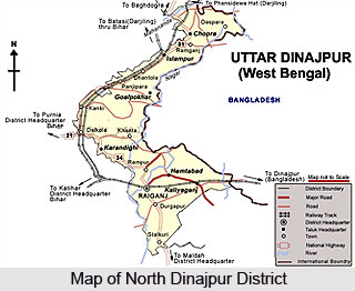 North Dinajpur District lies in the state of West Bengal. It came into existence on 1st April 1992, after after the bifurcation of erstwhile West Dinajpur District. The District lies between latitude 25 degrees 11minutes north to 26 degrees 49 minutes North and longitude 87 degrees 49 minutes east to 90 degrees 00 minutes east. It occupies a total area of 3142 Sq. Kms and is enclosed by Bangladesh on the East, Bihar on the West, Darjeeling and Jalpaiguri District on the North and Malda District on the South. North Dinajpur is well connected with the rest of the State through National Highways, State Highways and Railways. NH-31 and NH-34 passes through the heart of the district. The regional topography is generally flat with a gentle southerly slope.
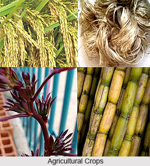
North Dinajpur district has been blessed with a very fertile soil. The district forms a part of the basin lying between Rajmahal hills on the East. The older alluvium is estimated to be Pleistocene age. The soil is very rich in nature due to the alluvial deposition which helps to grow Paddy, Jute and Mesta, sugarcane etc. Raiganj on the bank of the River Kulik is the District Headquarter where Raiganj Wildlife Sanctuary, the second largest bird sanctuary in Asia situated.
The district has good annual rainfall of about 160 cm. The rivers are either rain fed or are perennial with their source being the snowmelt of the Himalayas. The main rivers in the district are the Mahananda River, Kulik, Dauk, Nagar, Sudhani and a number of other streams. This river network provides sufficient surface water all over the district. Underground water supply and management is satisfactory in this region through Tube Wells, Deep Tube wells and other pump sets.
The North Dinajpur district is primarily agricultural in nature. Here, due to its diverse and surplus production of various crops like tea, jute, potato, ginger, spices and pineapple etc. the district has a strong base for agro-based and horticulture- based industry. Due to the suitability of climate and the fertility of soil, the district of North Dinajpur produces a number of fruits. Among the major fruits grown here are mango, jackfruit, litchi, sapota, guava, citrus fruits, banana, papaya, pineapple, cashew nut and coconut.
Since the district is mainly agriculture-based, high yield seed, agriculture accessories etc are distributed among the farmers at subsidy rate through various schemes. Also, training is imparted on developed and scientific ways of cultivation through display centres and training centres. Farmers have much been benefited by these schemes. Where industries are concerned, the district of North Dinajpur has as many as 9 large and medium scale industries and about 1261 registered small scale units.
Demography
According to the demographic survey of 2001, north Dinajpur has an average population of nearly 25 lakhs and the rural areas are densely populated. Majority speaks Bengali but Hindi and Urdu is spoken by minority section in the Islampur subdivision.
Education
The district however does not provide sound base of education to the inhabitants there. As per the 2001 census, there were only 232 literates all over the district. Though there is a band of primary school, the standard of higher education is beneath the desirable rate.
However, several NGO`s have been working to set developments in the region. They maintained some schools and have developed some welfare societies to induce the social upliftment of the rural sectors.
Economy of North Dinajpur
 Dinajpur, at the northern part of West Bengal is not economically sound and the very basis of its economy is the forest resources, which abound in plenty. The humid tropical climate induces the rapid growth of the mixed deciduous forest.
The forest distributed irregularly provides the varied raw materials for the growth of forest-based industries. The wood products and the firewood constitute the principal materials for the forest-based industries. Essentially a rural economy, the forest based industry provides employment to the rural populace. The per capita consumption of the firewood in the rural areas is 7,30,000tonnes. The surplus of firewood is exported. Firewood is the chief source of earning foreign exchange.
As the forest in Uttar Dinajpur is highly productive and accounts for the largest quantity of export, the government has undertaken several steps for the inception of social forestry, thereby bringing the un-utilized area under forest. The social forestry has reduced the burden of the natural forest to some extent. Several kinds of hybrid variety trees have been planted which gives the maximum output than the natural forests. Thus social forestry is supplementary to the natural forest, supporting the rural economy greatly.
With the augmentation of social forestry special emphasis has been offered to the development of the Canals, rivers & railway embankment etc. for the easy transport of the forest products. During the construction of the infrastructure, a large volume of local folk was employed which served the economy to a large extent. Moreover the forests also served the local demand of timber, firewood, pole and fodder. The cottage industries in the region specialize in the products of timber and firewood. The handicrafts, which employed mainly the rustics, at the same time serving the domestic purpose, also get exported to the neighboring areas.
The topographical feature of North Dinajpur is essentially a flat made up of alluvium soil estimated of the Pleistocene age. Moreover the three rivers -Kulik, Nagar and Mahananda, feed the region, forming a part of basin between the Rajmahal Hills in the east. The physical feature is highly conducive for agriculture. The economy that is why is predominantly controlled by the agriculture. The soil is supportive for the cultivation of paddy, jute, Mesta, sugarcane. This crops mainly supports for the local demands of food. All the varieties of the paddy are cultivated in North Dinajpur
The favorable kind of soil also supports the growth of horticulture and the orchard crops. The slopes in the northern part help in the tea plantation. Potato, Ginger and spices are the important crops, which as well as, supplying the domestic industries and earns foreign exchanges. The pineapple of Dinajpur is highly in demand in the areas throughout the country.
Raipur, the district headquarter is a principal center of agriculture-trade and jute exporting in North Dinajpur.
Forestry in North Dinajpur District
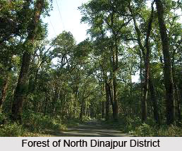 Forestry in North Dinajpur is immensely important owing to a number of forest based industry in the district. About 0.19 % of the total geographical area of the district which is about 1483.75 acres of land is under forest cover. The area covered by forest in the district of North Dinajpur is quite less. Tropical Moist and Mixed Deciduous Forests forms the major forest cover where main species found are Sissoo, Simul, Khair, Akashmoni, Khadam, Jarul, Arjun, Sal and many more. Teak is also found in some patches. The distribution of forests is very irregular and mostly spread in small pockets. There are some pockets of natural forests of 282.11 acre. The rivers of Kulik, Nagar and Mahananda flow through the district and provide great fertility to the soil; paddy, jute and sugarcane are grown in large numbers.
Forestry Activities in North Dinajpur District
A number of forestry activities are carried out in the North Dinajpur District. For bringing the non utilizable land lying outside the Government Forest area under forest cover, Raiganj Social Forestry Division has been created. The initial steps of social Forestry project included identification of uncultivated land. Emphasis has been given to the linear strips that run along the roads, rivers, canals and railway embankment. Under the project, many sterile waste lands belonging to private individuals were also identified. Meeting the local demand of fire wood, timber, fodder, pole etc and providing employment through plantation were the main objectives of this project.
Forestry and Employment in North Dinajpur District
Rural population of the district is greater than the urban population and thus the dependence on forest products is much more. Thus the forestry project has greatly reduced the problems of low forest cover. Per capita annual consumption of fire wood has been estimated in the rural areas of the district to be 7, 30,000 tonnes.
Forest Based Market and Industry in North Dinajpur District
During Kharif and pre-Kharif season, Paddy is mostly produced in the district. Rest of the industry is artisan oriented where forest based handicrafts are produced. Small scale and cottage industries are scattered throughout the district. Major forest based industry of North Dinajpur District include Saw Mill Industries and Ply Wood and Veneer making Industries.
Tourist Spots in North Dinajpur
•Sap-nikla forest, located 22 km from Islampur where visitors can visit the lake and forest for sight seeing.
•Karnajora Museum and park
•Burhana Fakir"s Mosque
•Goddess Kali"s temple at Baira
•Malgaon and Kunore - Famous for terracotta work
•Goddess Bhairabi"s temple at Bindore
•Kunore - famous for terracotta pottery & Malgaon.
•Banabithi Resort at Barui, Barduari.
•Farm-House at Samaspur, Hemtabad
Developmental Projects in the Forestry of North Dinajpur
In the context of North Bengal Forests, the Social Forestry Plantations have not yet been able to take pressure off the natural Forests. Government Forest contain a higher proportion of big size timber from valuable species (e.g. Sal, Teak etc), than strip plantation and farm forestry. The strip plantation are also prone to theft, damage, fire, grazing and encroachment and therefore, not much timber and fire wood remains available at the time of harvesting to meet the local demand fully. But for the land outside the control of the Government is still lying in unplanned productivity condition in respect of forestry. There is scope of enhancement of production in these lands. Possible Developments in the forestry would be Medicinal and Aromatic plants like Ashok, Swarpagandha, Lemon grass, Makna, Kalamegh, Nichinda, Costach, Abir, Isabgol, Ming Oil, Menthanol, Jasmine essence possible export items which are already being planted in some parts of the district.
Population increase in the district has greatly enhanced the need of forest products. Owing to this, much efforts has been put to increase the productivity and various projects have been taken up. Social Forestry activity has augmented the forest productivity and has supported the forest based small scale industry to a great extent.
Tourism
The district of Dinajpur in West Bengal is dissected, the major part of which falls under the present area of Bangladesh. Bounded within a small tract, the area of North Dinajpur does not have a lot of places, attracting tourists. However, mention may be made of the forests and the sanctuaries in the Districts.
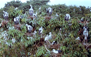 The diversified flora of deciduous variety here forms the dense, impenetrable forest, which is undoubtedly a place of immense interest for people loving forest. Sapnikla forest is the famous tourist spot, where the tourist can enjoy a beautiful lake. Several sanctuaries maintained by the state government have been grown up here. The principal one is the Raiganj bird Sanctuary, which is one of the largest sanctuary in Asia lies along the National Highway 34, which extends over an area of 35 acres. The diversified Avifauna is the key attraction here. A number of migratory birds including open billed storks, knight herons, egrets and cormorants and a large species of indigenous birds are found here.
There are a number of temples and mosques in the region, which attracts a bunch of pilgrims in the region. Goddess Bhairabi`s Temple at Bindore and Goddess Kali`s temple at Baira are the notable ones. Burhana Fakir`s mosque famous for its architecture, which also represents the culture of the Muslims, once inhabited the land. Malgaon and Kunore are famous for the terracotta work. The small cottage industry is an important sight of interest in the region. Karnajora Museum & Park is famous for the collection of a rare kind of flora & fauna. Due to the lack of the tourist centers of ample variety, the tourism is not well developed here.


