 Elephanta Island, also called `Gharapuri Island` or `place of caves` is one of a number of islands in Mumbai Harbour, lying east of Mumbai in India. Elephanta Island is a popular tourist destination. It features seven decorative cave temples called the `Elephanta Caves` that are carved out of rock.
History of Elephanta Island
In the ancient times, Elephanta was known as Gharapuri. The present name Elephanta was given by 17th century Portuguese explorers. They gave the name after seeing a monolithic basalt sculpture of an elephant found here near the entrance.
The explorers decided to take the sculpture home but they dropped it into the sea because their chains were not strong enough. Later, this sculpture was moved to the Victoria and Albert Museum (now Dr. Bhau Daji Lad Museum) in Mumbai, by the British.
Architecture of Elephanta Island Caves
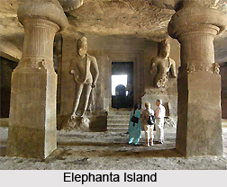
Elephanta Island comprises of several caves that one can explore. The caves are divided into two groups. The first group consists of Stupa Hill which is situated in the east. It contains two caves, one of which is undeveloped. The second group is present in the west and comprises of five rock-cut Hindu shrines. The main cave is popular for its beautiful carvings to the glory of Shiva, who is exalted in various forms. The cave consists of a square plan mandapa whose sides measure about 27 m. The walls of the mandapa are adorned with pictures of Shiva.
 The interior is divided up into smaller areas by rows of supports. The whole shape looks like a building; false profiled beams have been carved in the roof of the cave and the supports.
At the very entrance to the cave, to the north of an esplanade reached by a steep flight of steps, one will find two large carved panels depicting, on the left, Shiva Yogisvara and, on the right, Shiva Nataraja, both treated in a monumental style. In a chapel on the right of the entrance stands the cylindrical lingam, which is regarded as the symbol of the Supreme Being and principle of all energy. The chapel has four doors, each flanked by colossal figures of dvarapala.
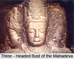
Opposite the entrance, on the south wall, is the famous three-headed bust of the Mahadeva, whose three faces are the incarnation of three essential functions; to the east, Aghora or Bhairava, terrifying destroyer; to the west, Vamadeva, creator of joy and beauty, incarnated by a woman`s head; and in the centre, Tatpurusha, master of positive and negative principles of existence and preserver of their harmony.
Connectivity of Elephanta Island
The Elephanta Island is easily accessible by ferry from Mumbai, being about 10 km from the south east coast of the island city. Boats leave daily from the Gateway of India and take about an hour each way for the journey. From the boat landing stage on the Elephanta Island, a walkway leads to steps that go up to the famous caves.
Along the path, several hawkers sell mementos, paintings etc that can be possessed at a reasonable price. There are also stalls to buy food and drinks in the Elephanta Island.