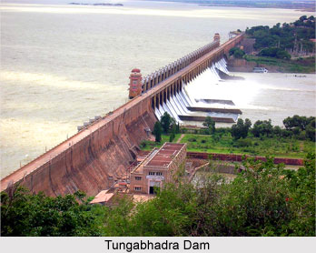
 The Tungabhadra dam is 2441 metres long and its height is 49.38 metres. This dam is built on the Tungabhadra River at Mullapuram in the Bellary district. The River Tungabhadra is a tributary of the Krishna River. It is located at a distance of about 4.8 kilometres from Hospet. This is one of the largest multipurpose dams of the state of Karnataka. The Tungabhadra project also consists of three major canals, one on the left bank side and another on the right bank side. They are known as the Left Bank Canal, the Low Level Canal and the High Level Canal.
The Left Bank Canal is 225 kilometres long and having a capacity of 7000 cusecs cubic feet per second. It has the capacity to provide water for irrigation to about 3 lakh hectares of land in the Raichur and Bellary districts of the state of Karnataka and Anantpur, Kurnool and Cuddapah districts in the state of Andhra Pradesh. The Low Level Canal is 349 kilometres long. Starting from the right flank of the Tungabhadra River, this canal runs through the Indian state of Andhra Pradesh. This project has the capability to irrigate a total of about 97,566 hectares of agricultural land in the states of Andhra Pradesh and Karnataka. The Power Canal on the Right Bank side sustains the power house at Hampi. The High Level Canal has a total length of 196 kilometres. The capacity of this canal is 4999 cusecs at the head. This canal offers irrigation facilities to about 80900 hectares of agricultural land in the state of Karnataka and 101900 hectares of land in the state of Andhra Pradesh.
Apart from the three main canals, the Tungabhadra project also possesses two powerhouses with a collective installed capacity of 72 MW. The power generated by both the powerhouses is distributed between the States of Andhra Pradesh. Furthermore, NCL Energy Ltd, a company which is based in Hyderabad, has been selected to set up a mini hydra project with a capacity of 8.25 MW on the Right Bank High Level Canal. The cost of the project is likely to be Rs 22.20 crores. The basin of the High Level Canal close to the dam has been selected as the future location of the powerhouse and the powerhouse is anticipated to have three units each with a capacity of 2,750 KV. The plant is expected to produce a gross energy of 30 million KW hours per annum. The project will be exploiting the water released from the Tungabhadra dam reservoir into the RBHLC in order to generate power. The energy generated at the project will be supplied to the two states of Karnataka and Andhra Pradesh in India.
The present day functioning of the Tungabhadra project include the regulation of supplies of water to the States of Karnataka and Andhra Pradesh. Regulation of power from the two power houses on the right side in accordance with such rules as may be made on this behalf by the Board and the maintenance of the dam and reservoir of the project, common to both the States, which includes undertaking safety measures for the dams and spillway.
In the current functioning of this project, the maintenance of the common portion of the Right Bank High Level Canal and Low Level Canal as well as the common distributaries of Right Bank Low Level Canal and any other works common to both the States of Andhra Pradesh and Karnataka are included. The Tungabhadra project also facilitates fisheries in the reservoir as well as the main canal. The project also looks into the proper utilization of the land which was acquired for this purpose and the development of new schemes for the generation of hydro electric power.


