 Hirakud Dam is a longest dam in the world located in Odisha.
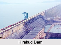
Location of Hirakud Dam
Hirakud Dam stands in the Sambalpur district across the Mahanadi River. Hirakud is not only the longest earthen dam but also the biggest artificial lake in Asia which has a storage capacity of 743 sq km and a shoreline of over 640 km
History of Hirakud Dam
Hirakud Dam was built in the year 1957 and is the largest earthen dam that exists. It is also a major multipurpose river valley project in India that was built after India was liberated from the British Government in India in the year 1947.
Geography of Hirakud Dam
The Hirakud is 6 km from NH (National Highway) and 8 km from the Hirakud Railway Station. It is 61 m in height and 4801 m in length, stretching between the hills of Lamdungri in the left and the Chandili, Dunguri on the right. The dam has 21 km of dykes.
Construction of Hirakud Dam
The construction of Hirakud Dam dates back to the period of devastating floods in the year 1937. The foundation of the dam was laid by Sir Howthrone Lewis, the governor of Odisha , on 15th of March, 1946. A project report was provided to the government in June 1947. Jawaharlal Nehru officially inaugurated Hirakud Dam in the year 1957. The project had started functioning at its full capacity from the year 1966.
Purpose of Hirakud Dam
Hirakud Dam regulates the flow of the Mahanadi River and as a result alleviates the situations of floods at various regions. Not only does the dam control floods but also it relieves the situations of drought. Another important function of the dam is to produce hydro electricity with the help of several hydro-electric power plants.
Projects on Hirakud Dam
The entire project of Hirakud consists of 3 dams namely the Hirakud dam, the Tikarpara dam and the Naraj dam. It provides 1, 55,635 Hectares and 1, 08,385 Hectares of irrigation to Rabi and Kharif crops respectively in the districts of Sambalpur, Bargarh, Bolangir, and Subarnpur in Odisha . The water released through the power house irrigates a further 436000 Hectares in the Mahanadi delta. The two powerhouses at Burla and Chiplima have a cumulative installed capacity of 307.5 MW. The main aim of the Hirakud dam project is to control the flow of the Mahanadi River, which, with a catchments area of 132000 sq km, has alarming floods from time to time. Hirakud dam intercepts 83400 sq km (32200 sq miles) of Mahanadi catchments.
Canals of Hirakud Dam
The project provides flood protection to 9500 sq km of delta area in the districts of Cuttackand Puri. The entire irrigated patch of land of the dam constitutes two canal systems. They are the Sason canal and the Bargarh canal. Each canal is of different type: the Sason canal is of the ridge type and the Bargarh canal is of the contour type.
Management of Hirakud Dam
The Chief Engineer, two Superintending Engineers and seven Executive Engineers and their staff are concerned with the maintenance and repair of the dam with the funds allotted to the Chief Engineer by the State government from time to time. The difference between the ridge type canal and the contour type canal is that the ridge type canal does not have banks on either side unlike the contour type canal.
Benefits of Hirakud Dam
A very important benefit of the Hirakud Dam is that it has facilitated the exploitation the rich resources of Odisha like iron, coal, manganese, bauxite, chromite and limestone. At present, the Hirakud project has facilitated power supply to an aluminium plant at Hirakud paper mills at Brijrajnagar, cement works at Rajgangpur, iron and steel plant at Rourkella and several other industries in Cuttack District, Puri District, Sambalpur District, Kendujhar District, Mayurbhanj, Bolangir District and other districts. In the recent years pisciculture has been a growing activity in the areas around the Hirakud Project.
Tourism of Hirakud Dam
Cattle Island which stands at one extreme of the Hirakud Project has become an area of tourist attraction. Cattle island is nothing but a submerged hill which used to be a village before the establishment of the dam. After the construction of the dam the hill was surrounded with water from the reservoir and henceforth has become an island. The cattle from the earlier village managed to survive and now have become wild and are not easily tamed. Moreover, The Debrigarh Wildlife Sanctuary is situated near the Hirakud Dam.
Related Articles
Resources in India
Water Resources in India
Dams in India
Dams in Odisha
Odisha, Indian state
Temples of Odisha
Nature Tourism in Odisha
Puri
Hirakud Dam
Hirakud Dam is located in Sambalpur District of Odisha. This is the longest dam in the world and also an important multi purpose project and one of the major tourist attractions in eastern India.


