 Dams in Gujarat were mainly constructed to control floods, but they later started to function as water suppliers and reservoirs. Out of a total of 541 Indian Dams, Gujarat has around 21 large dams. In general, the Dams in Gujarat play an important role in the development of the state and the lifestyle of the people of Gujarat. The five chief dam related projects of Gujarat are Sardar Sarovar, Ukai, Dantiwada, Kadana and Dharoi dam projects. These projects are considered to be the main sources of water for irrigation and drinking across the state. These 5 dams in Gujarat hold national significance. Given below are some of Dams in Gujarat.
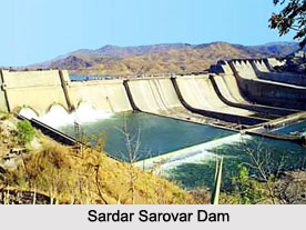
Sardar Sarovar Dam
Sardar Sarovar Dam was one of the main projects executed in Gujarat. 30 large dams were planned for Narmada River in Gujarat. Sardar Sarovar Dam being the largest is a gravity dam and has a height of around 163 meters. The multi-purpose Sardar Sarovar Project (SSP) irrigates a land of more than 1.8 million hectares.
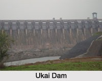
Ukai Dam
Ukai Dam has been constructed across the Tapti River in Surat district. It has the largest reservoir in Gujarat known as "Vallabh Sagar". It is the second largest dam in the state and has the second largest storage capacity among the existing dams in Gujarat. Ukai Dam has a height of about 80 meters.
Dantiwada Dam
 Dantiwada Dam is located on the outer reaches of Dantiwada in Banaskantha District of Gujarat. The mud and masonry dam stands across the Banas River and was built in the year 1965. The principal reasons behind the construction of Dantiwada Dam were flood control and provision of water for irrigation projects in the state. The dam is nearly 61 meters high and 4,832 meters long. The reservoir covers an area of about 40 square kilometers. The dam is considered to be a prime tourist attraction of the district and attracts many visitors to its scenic surroundings and natural beauty. Situated nearby is Balaram Ambaji Wild Life Sanctuary that forms the division between the Dharoi Dam and Dantiwada Dam.
Dharoi Dam
Dharoi Dam is located at Dharoi in Sabarkantha District. Dharoi Dam was constructed for supplying drinking water to urban areas including Ahmedabad, which is located around 85 kilometers away. Dharoi Dam was built across Sabarmati River in the year 1973. The dam is one of the popular tourist spots of Gujarat.
Kadana Dam
Kadana Dam is another popular dam of Gujarat. More specifically, it is masonry with embankment dam and the prime objective behind its construction on Mahi River was to control floods in the catchments. It is an area where frequent floods take place, whenever around 10 lakh cusec of water is released from the Kadana Dam. With profound rains in the catchments of Rajasthan, huge amount of water is released in this dam. During the monsoon season, the water level in the Kadana Dam increases up to 412.75 ft.
Dholidhaja Dam
Dholidhaja Dam, located in Surendranagar is the chief source of water for the cities of Wadhwan, Joravarnagar, Ratanpar and Surendranagar. The dam is on the Bhogavo River and supplies clean drinking water to almost 4 lakh people in and around the cities.
Kamleshwar Dam
Kamleshwar Dam or Hiran I Dam is located inside the Gir Forest National Park on the Hiran River in Visavadar, Junagadh district. It is a rock-fill embankment dam with a height of about 25 m. The reservoir is famous for crocodiles and birds.
Other Dams in Gujarat
Some of the other Dams in Gujarat are Khodiyar Dam, Mitti Dam, Sukhi Dam and Nayka Dam.
Dams in Gujarat
Dams in Gujarat play a vital role in flood control, provide adequate water to the people and are utilized for agricultural purposes.


