 There are several forests and sanctuaries along the River Narmada and they are some of the distinguished ones in India. Teak and India`s best hardwood forests are found along the Narmada River and are affluent in the basin. Moreover, these teak trees are much older than the ones in the Himalayas.
The lower Narmada River Valley and the adjoining uplands, covering an area of 169,900 km² is abundance of dry deciduous forests. The Ecoregions lies between moister forests to the northeast, southeast, and southwest and these areas receive greater rainfall from the southeast monsoon. The drier forests and scrublands of the Deccan to the south and Malwa and Gujarat to the west and northwest in the Narmada basin do not receive that much rainfall. The natural vegetation of the region can be categorized as three-tiered forest.
Some of the distinguished species of plant are as follows
•Teak or the Tectona grandis is the dominant canopy tree, in association with Coromandel Ebony or the Diospyros melanoxylon
•Dhaora or Anogeissus latifolia, Lagerstroemia parviflora, Terminalia tomentosa.
•Lannea coromandelica, Hardwickia binata and Boswellia serrata.
•Riparian areas, which are along the rivers and streams receive year-round water and are home to moist evergreen forests, whose dominant tree species are Terminalia arjuna, Syzygium cumini, Syzygium heyneanum, Salix tetrasperma, Homonoia riparia, and Vitex negundo.
The Ecoregions is home to 76 species of mammals, and to 276 bird species none of which are rare or endemic. According to the World Wildlife Fund, almost 30% of the Ecoregions is sheltered in relatively intact vegetation. The Ecoregions includes some large blocks of environment in the Vindhya and Satpura ranges. Around 5% of the Ecoregions lies within protected areas, including the Bandhavgarh, Panna, and Sanjay national parks.
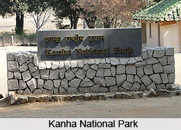
There are many important national parks and wild life sanctuaries in the valley. The Kanha National Park is located in the upper courses of Narmada almost 18 Km from Mandla boasts of several wild animals including the Tiger. The two tributaries of Narmada, Hallon and Banjar flow across this park. It is one of the best National Parks in Asia, which has been described brilliantly by Rudyard Kipling in his famous creation Jungle Book.
Satpura National Park was constructed in 1981and is located in Hoshangabad district of Madhya Pradesh, India. The name of this park is derived from Satpura hill ranges (Mahadeo hills) and covers an area of 524 km² and along with the adjoining Bori and Panchmarhi Sanctuaries, provides 1427 km² of unique Central Indian Highland ecosystem. Satpura National Park is a unique ecosystem and is very rich in biodiversity. The fauna comprises tiger, nilgai, sambar, chital, leopard, Bhedki, four-horned antelope, chinkara, wild dog, bison (gour), wild boar, fox, bear, porcupine, black buck, flying squirrel, Indian joint squirrel, mouse deer and many others. There are a variety of birds. Hornbills and peafowl are the most seen birds. The flora of the national park consists of mainly sal, bel, teak, aonla, tendu, mahua, bamboo and a variety of grasses and medicinal herbs.
Mandla Plant Fossils National Park, Dindori National fossils park Ghughuya is situated in Dindori district of Madhya Pradesh in India. This national park has plants in fossil form that existed in India anywhere between 40 million and 150 million years ago spread over seven villages of Mandla District. The district covers the regions of Ghuguwa, Umaria, Deorakhurd, Barbaspur, Chanti-hills, Chargaon and Deori Kohani. The Mandla Plant Fossils National Park is a park encompassing an area over 274,100 square metres. Such fossils are available in three other villages of the district also, but they lie just outside the national park.
One theory is that the area in which the fossils are located, i.e., the Narmada Valley near Mandla, was once upon a time a deep inundation of the sea into peninsular India till the Post- Cambrian Tertiary age that was about 40 million years ago. This means that Narmada had been a very short river which deceased in the inland sea above Mandla, and that the recession of the sea effected in geological disturbances, which created the present rift valley across which the Narmada River and Tapti River flow in their present journey to the Arabian Sea. All this, however, is an assumption and conjecture because it is only recently that an interest has developed regarding the fossils of Mandla and explained the scientific studies and more research is being done.
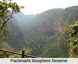
The Pachmarhi Biosphere Reserve covers few zones of three civil districts, including Hoshangabad, Betul and Chhindwara of Madhya Pradesh. The total area of this park is 4926.28 sq km. 3 wildlife conservation units, namely Bori Sanctuary (518.00 sq km), Satpura National Park (524.37 sq km), and Pachmarhi Sanctuary (461.37 sq km) are included in the periphery of this park. Satpura National Park comprises the core zone and the remaining area of 4501.91 sq km surrounding the core zone serves as shock absorber zone. The area is made up of around 511 villages. The area displays a wide variety of geological rock and soil formations. There is a wide range of floral and faunal uniqueness that occupy the Satpura conservation area. It is one of the oldest forest reserves in the country, which has an established tradition of scientific management of forests. It constitutes a large adjacent forest block that harbors a variety of plant and animal species typical of the central highland region.
 Apart from the above national parks, there are also a number of natural preserves in Narmada river basin such as the Amarkantak, the Bagh Caves, and the Bhedaghat. In the association of the Environmental Action Plan for the Narmadasagar and Omkareswar HEPs, as per the recommendations of the Wildlife Institute of India, 3 new protected areas are created, which are the Narmada National Park (496.70 km2), Surmanya Sanctuary (126.67 km2) and Omkareshwar Sanctuary (119.96 km2). All these sanctuaries comprise a total area of 788.57 km2.
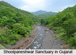
Shoolpaneshwar Sanctuary in Gujarat, near the Sardar Sraovar dam site was earlier called the Dumkal Sloth Bear Sanctuary. This is the old sanctuary that has been expanded four times and presently covers an area of about 607 sq.km. A major watershed feeds the Sardar Sarovar and Karjan reservoir on the Karjan River that is a tributary of Narmada in Gujarat. It is the environment of mammals and a variety of birds, including the eagles and hawks. Rajwant palace resort is a lovely place offering accommodation near the sanctuary.
Forests and sanctuaries along Narmada
The forests and sanctuaries along the River Narmada have special significance for its collection.


