 The Mahakali River flows between the border of Nepal and India. This river forms the western international border between Nepal and India and it originates from the Greater Himalayas at Kalapaani. The river flows down from a height of 3600 m, in the Pithoragarh District of Uttarakhand, India. Eventually, it joins with the Gori Ganga at Jauljibi area. This river again joins the Saryu River at Pancheshwar. The vicinity around Pancheshwar is called `Kali Kumaon`. Kalapani is located on Kailash Lake Mansarover trek and it is said that at this place the Great Sage Vyasa meditated and the valley is called Vyasa valley. The river is named after the Goddess Kali and her temple is situated in Kalapaani near the Lipu-Lekh pass at the border between India and Tibet.
The river flows at the periphery of the Nepalese Mahakali Zone and the Indian state of Uttarakhand. This site was earlier the Nepalese military base during the Gurkha War. The Sugauli Treaty signed by Nepal and British India in 1816, after the end of the war, locates the Mahakali River as Nepal`s western boundary with India. The river flows in a gorge section in the upper region. The Mahakali after it flows into the plains of India is called the River Sarda, later it meets the Ghaghara (Karnali in Nepal) in Indian Territory at about 323.5 km 1 & 6 from the existing Upper Sarda Barrage at Banbasa.
Mahakali flows for a length of around 223 km length in Nepal and 323.5 km in India up to its confluence with Ghaghra River. The Mahakali is one of the five major river basins of Nepal, which is shared with India and has a total basin area of 14871 km2 up to Upper Sarda Barrage, about 34 per cent of which lies in Nepal. The total catchment area is around 17,818 km2 up to Lower Sarda Barrage 1. Kumaon of Champawat district and part of Udham Singh Nagar district are under the Sarda basin. None of the larger tributaries join the Sarda between Upper Sarda and Lower Sarda barrages in India. In Uttar Pradesh, part of Lakhim-Kheri district is also considered to be under the Sarda basin.
The important towns and villages along the banks of this river include Amargadhi, Chandani, Kalika, Dodhara, Dasrathchand, Dharchula Bazar, Patan, Mahendranagar city and others in Nepal. Balwakote, Banbasa, Jauljibi, Champawat, Lohaghat, Titri, Handeshar, Munsiyari, Jhulaghat, Pancheshwar, Tanakpur and others lie in India to the west of Mahakali river.
The important national parks beside this river are the Shuklaphanta Wildlife Reserve in Nepal and the Dudhwa National Park at the Indo-Nepal border in India. Water Rafting in Kumaon Region is considered to be one of the premier modes of recreation. As the river flows down from the Nepal border through Kumaon hills and as the Kali and Gori Rivers meet at Jauljibi, with greater than before water volume, it offers grand river rafting adventure to professionals, for a length of 117 km, from Jauljibi to Tanakpur. Below Tanakpur, lowered down among the ice-covered slopes, the river becomes calmer thus offering the amateurs, a sporting challenge.
Places of Religious interest in the Mahakali River basin - In the Kumaon region in India every peak, lake or mountain range is somehow associated with some myth or the name of a God or Goddess, ranging from those associated with the Shaiva, Shakta and Vaishnava traditions, to local Gods like Ham, Saim, Chhurmal, Kail Bisht, Golla, Bholanath, Gangnath, Airy and Chaumu. In Kumaon, Famous temples are the Kali temple at Kalapani, Shiva temple of Singhphal in Dudhwa reserve, the Baleshwar temple at Champawat, an Indian National Heritage Monument of Archaeological Survey of India and Nagnath temple in Champawat.
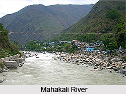
Mahakali River
Mahakali River is also known as Sarda River and flows in between the border of Nepal and India.


