Budhi Gandak River, Indian River - Informative & researched article on Budhi Gandak River, Indian River
 Indianetzone: Largest Free Encyclopedia of India with thousand of articlesGeography of India


in  
 Art & Culture|Entertainment|Health|Reference|Sports|Society|Travel
Forum  | Free E-magazine  | RSS Feeds  
Geography of India : Indian Climate |Indian Mountains |Indian Forests |Indian Soil |Indian Vegetation |Animal Husbandry in India |Resources in India |Indian Demography |Indian Natural History |Indian Astronomy |Indian Industries |Indian Islands |Indian Airports |Zoos in India |Indian Mines and Minerals |Indian Physiography |Indian Transport |Indian Geology |Communication in India |Indian Trade |Indian Astronomers |Indian Telecommunications
Home > Reference > Geography of India > Resources in India > Water Resources in India > Indian Rivers > Inland Drainage Basin > Budhi Gandak River
Budhi Gandak River, Indian River
Budhi Gandak River is a significant river of India.

 Budhi Gandak River, Indian River
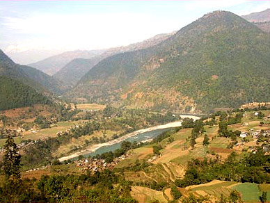
Budhi Gandak River is a significant river flowing in northern India. The other river named the Gandak is a much broader river originating from the Himalayas in Nepal. The origin of Budhi Gandak is at the West Champaran near Ramnagar and Bagaha. The river passes through various districts of Bihar including the East Champaran, Muzaffarpur, Samastipur and Khagaria. The river flows into Ganges River near Khagaria or Manasi.

This article is a stub. You can enrich by adding more information to it. Send your Write Up to content@indianetzone.com

(Last Updated on : 06/10/2010)
 
 
Mahi River Jaldhaka River Subarnarekha River
Shipra River Kameng River Vidarbha River
Teesta River Sindh River Sankh River
Rangeet River Pahuj River Kwari River
Koel River Kaliasote River Kali Sindh River
Bawanthadi River Brahmaputra River in India Budhi Gandak River
Damodar River Halali River Meghna River
Baitarani River Kathajodi River  
Recently Updated Articles in Geography of India
Trisuli Peak
Trisuli is situated at an elevation of 7,074 metres above mean sea level in the Pithoragarh district of Uttarakhand.
Suj Tilla East Peak
Suj Tilla East situated in the Pithoragarh district of Uttarakhand is a part of the Kumaon Himalaya division.
Siniolchu Peak
Siniolchu is one of the tallest mountains in Sikkim situated at a height of 6888 meters (22,598 feet).
Nun Kun Peaks
Nun Kun peaks are the two neighboring peaks of the Himalayan range, lying close to Jammu and Kashmir.
Nanda Kot
Nanda Kot is a mountain peak in the Kumaon Himalayan range .
E-mail this Article | Post a Comment
Forum
Forum on Geography of India
Free E-magazine
Subscribe to Free E-Magazine on Reference
 
 
Budhi Gandak River, Indian River - Informative & researched article on Budhi Gandak River, Indian River
Sitemap
Contact Us   |   RSS Feeds
Copyright © 2008 Jupiter Infomedia Ltd. All rights reserved including the right to reproduce the contents in whole or in part in any form or medium without the express written permission of
Jupiter Infomedia Ltd.