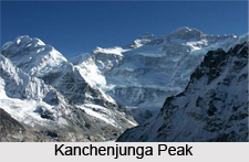
 Kangchenjunga Peak, also known as Sewa Lungma in Limbu language and is the third highest mountain in the world, after Mount Everest and K2. Kangchenjunga has an elevation of 8,586 metres or 28,169 ft. Kangchenjunga literally means the Five Treasures of Snows. Since Kangchenjunga contains five peaks, four of them over 8,450 metres. The treasures represent the five repositories of god, which are gold, silver, gems, grain, and holy books. Kangchenjunga is also called Sewalungma in local Limbu language and considered holy in Kirant religion.
Three of these five peaks of Kangchenjunga are called the main, central, and south and they lie on the border of North Sikkim district of Sikkim, India and Taplejung District of Nepal, while the other two completely lie in Taplejung District. Nepal is home to the Kangchenjunga Conservation Area Project controlled by the World Wildlife Fund in association with HMG in Nepal, the sanctuary is also home to the Red Panda and other snow animals, birds and plants. India`s side of Kangchenjunga also has aprotected park area called the Khangchendzonga National Park.
Although Kangchenjunga is the official spelling that was declared by Douglas Freshfield, A.M. Kellas, and the Royal Geographical Society that gives the best suggestion of the Tibetan pronunciation, there are a number of alternative spellings, which include Kangchen Dzo-nga, Khangchendzonga, Kanchenjanga, Kachendzonga, Kanchenjunga or Kangchanfanga. The final word on the use of the name Kangchenjunga was derived from His Highness Sir Tashi Namgyal, the Maharaja or chogyal of Sikkim, who said that although junga had no meaning in Tibetan, it was actually Zod-nga (treasure, five) Kang-chen (snow, big) that conveyed the meaning correctly.
Until 1852, Kangchenjunga was declared as the highest mountain in the world, but calculations made by the British Great Trigonometric Survey in 1849 and concluded that Mount Everest, known as Peak XV at the time was the highest and Kangchenjunga the third-highest. Kangchenjunga was first climbed on May 25, 1955 by Joe Brown and George Band of a British expedition. The British expedition honoured the beliefs of the Sikkimese, who hold the Kangchenjunga sacred, by stopping a few feet short of the actual summit. Most successful trekking groups since then have followed this tradition.
 The five peaks of Kangchenjunga are Kangchenjunga Main, Kangchenjunga West, Kangchenjunga Central (Middle), Kangchenjunga South and Kangbachen. Great ridges running roughly due east to west and north to south, forming a giant `X`, buttress the huge massif of Kangchenjunga. These ridges are made up of a host of peaks between 6,000 and 8,000 metres. On the East Ridge in Sikkim, is Siniolchu (6,888 m/22,600 ft). The west ridge culminates in the magnificent Jannu (7,710 m/25,294 ft) with its imposing north face. To the south, clearly visible from Darjeeling, are Kabru North (7,338 m/24,075 ft), Kabru South (7,316 m/24,002 ft) and Rathong peaks (6,678 m/21,910 ft). The north ridge, after passing through the minor sub-peak Kangchenjunga North (7741 m/25,397 ft), contains The Twins and Tent Peak, and rises up to the Tibetan border by the Jongsong La, a 6,120 m (20,080 ft) pass.
Kangchenjunga is a popular tourist spot and is known for its famous views from the hill station of Darjeeling. On a clear day, it presents a picturesque view not as much of a mountain but of a white wall hanging from the sky. The people of Sikkim admire Kangchenjunga as a sacred mountain. Permission to climb the mountain from the Indian administration is rare, but sometimes it is allowed. Owing to its remote location in Nepal and difficult access from India, the Kangchenjunga is not much explored by trekkers. It has, therefore, hold back much of its pristine beauty. In Sikkim too, trekking into the Kangchenjunga region has lately been permitted. The Goecha La trek is gaining popularity amongst tourists. It goes to the Goecha La Pass, located right in front of the huge southeast face of Kangchenjunga. Another trek to Green Lake Basin has recently been opened to public for trekking. This goes to the Northeast side of Kangchenjunga along the famous Zemu Glacier.
The Kangchenjunga Conservation Area (KCA) encompasses 2,035 km² surrounding the mountain on the Nepalese side. In 1848Joseph Dalton Hooker explored parts of the eastern Nepal previously completely unknown to Europeans. He made repeated tours of the river valleys into the foothills leading up to Kangchenjunga and reached within 22km of the peak, and the passes into Tibet. Following this event, many more expeditions were done to Kangchenjunga in 1855, 1882, 189, 1905 and so on. From the east Kachenjunga is accessible through Sikkim via Lachen and the Zemu Glacier. From the west it is accessible from the North-western Ridge. Every year a festival is celebrated during the early part of autumn, which is dedicated to the worship of the snow range of Kanchenjunga.


