Sharavati River - Informative & researched article on Sharavati River
  Indianetzone: Largest Free Encyclopedia of India with thousand of articles Geography of India


in  
Art & Culture | Entertainment | Health | Reference | Sports | Society | Travel
Forum  | RSS Feeds  | Free E-magazine
Geography of India : Indian Climate l Indian Mountains l Indian Forests l Indian Soil l Indian Vegetation l Animal Husbandry in India l Resources in India l Indian Demography l Indian Industries l Indian Islands l Indian Airports l Zoos in India l Indian Mines & Minerals l Indian Physiography l Indian Transport l Indian Geology l Communication in India l Indian Trade l Indian Astronomers l Indian Telecommunications
Home > Reference > Geography of India > Resources in India > Water Resources in India > Indian Rivers > Deccan Rivers > Sharavati River
Sharavati River
The Sharavathi River originates in Shimoga district of Karnataka and empties into the Arabian Sea at Honnavar .

Sharavati River at KarnatakaOne of the prominent rivers in Karnataka is the Sharavathi River, which originates in Karnataka and flows throughout the state. It is one of the few rivers in the India, which flows in the west direction. A large part of the river basin lies in the Western Ghats.

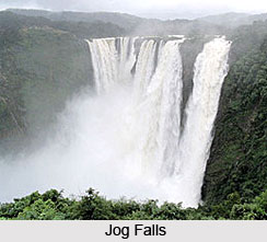
The source of the Sharavathi River is in Ambutheerta in the Thirthahalli taluk of Shimoga district. It empties into the Arabian Sea at Honnavar near Uttara Kannada district after flowing in the northwestern direction for about ninty-five kilometres. During its course, the Sharavathi River flows over even paths and gorges. This river falls to a depth of 253 metres forming the highest waterfalls in India, the Jog Falls. The total length of the river is Jog Falls formed by the Sharavathi riverone hundred and twenty eight kilometers and the major tributaries of the river are Nandihole, Haridravathi, Mavinahole, Hilkunji, Yennehole, Hurlihole, and Nagodihole.

The river basin falls in two districts of Karnataka namely, Uttara Kannada and Shimoga. The upstream river basin extends to two taluks of Shimoga district, which are Hosanagara and Sagara. The entire area drainage basin has an area of 2985.66 square kilometers with upstream of 1988.99 square kilometers. The soils in the Sharavathi basin are mainly lateritic in origin and reddish to brownish in colour.

The Sharavathi Hydroelectric was constructed to generate hydroelectricity from the river water. There are three power generating station in this project. The Sharavathi Generating Station, the Linganamakki Dam Powerhouse and the Gerusoppa Dam Project.

(Last Updated on : 19/01/2009)
  More on Deccan Rivers...
 
Achankovil River Adyar River Cheyar River
Chaliyar River Chalakudi River Penner River
Periyar River Tunga River Ponnaiyar River
Bharathapuzha River Sharavati River Mandovi River
Meenachil River Kallayi River Kannadipuzha River
Himayat Sagar Vedavathi River Vaigai River
Thamirabarani River Tamraparni River Kaveri River
Bhadra River Kapila River  
Recently Updated Articles in Geography of India
  • Grand Trunk Road
    Grand Trunk Road is one of the oldest, longest and most important roads of South-Asia.
  •  
  • Types of Forests in India
    Elevation, topography, climate and soil type are the major factors which determine the type of forest.
  •  
  • Sispara Peak
    Sispara Peak is an Indian mountain peak, situated in the south Indian state of Tamil Nadu.
  •  
  • Indian Railway Zones
    Indian Railway network is classified into seventeen zones for administrative purposes.
  •  
E-mail this Article | Post a Comment
Free E-magazine
Subscribe to Free
E-Magazine on Geography of India

 
Sharavati River - Informative & researched article on Sharavati River
Sitemap
Contact Us   |   RSS Feeds
Copyright © 2008 Jupiter Infomedia Pvt. Ltd. All rights reserved including the right to reproduce the contents in whole or in part in any form or medium without the express written permission of Jupiter Infomedia Pvt. Ltd.