 Kameng River flows in Arunachal Pradesh and Jia Bhoreli in Assam. Earlier it was known as Bhareli River. It is one of the chief tributaries of the Brahmaputra River. It is about 264 kilometers long. The drainage basin of Kameng River is about 11,843 square kilometers large. River rafting and kayaking that takes one through lush rainforests are the attractions of this river.
Origin and Course of Kameng River
The river originates in the eastern Himalayan Mountains, in Tawang district from the glacial lake below snow capped Gori Chen Mountain at an elevation of 6,300 metres or 20,669 ft on the India-Tibet border in South Tibet. Then it flows through Bhalukpong circle of West Kameng District, Arunachal Pradesh and Sonitpur District of Assam, India.
 It forms the boundary between East Kamemg District and West Kameng District. It also acts as the boundary between the Sessa and Eaglenest sanctuaries to its west and the Pakke tiger reserve to the east. On the east of the Kameng River falls Dafla Hills and on the west fall the Aka Hills which is known as the home of Aka tribe.
Tributaries of Kameng River
The eastern part of Eaglenest-Sessa Wildlife sanctuaries is shattered by the Tippi Naala or Tippi River, which joins Bhareli River at the village of Tippi on the Bhalukpong-Bomdila highway. The other major rivers like Tenga, Bichom and Dirang Chu in the West Bhareli District are also tributaries of the Bhareli.
Flora of Kameng River
Earlier there was a long stretch of forest along the Bhalukpong-Bomdila highway on the west bank of the river in West Kameng. In the last few years, the entire stretch of forest has vanished. However, the forest across the river continues to be in a vigorous flow.
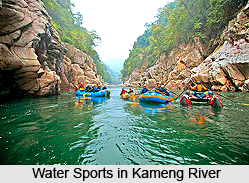
Water Sports Attractions of Kameng River
Water sports like kayaking and rafting have recently been introduced to this river. According to many adventure enthusiasts, it is one of the best river trips the Indian Himalayas have to offer. The raft takes one through Pakhui Tiger Reserve, Sessa and Eaglenest Sanctuaries. The river has white water and the adventure journey might offer one to spot various animals.
Kameng River
Kameng River, earlier known as Bhareli River, flows in Arunachal Pradesh and Assam. It is one of the chief tributaries of the Brahmaputra River.


