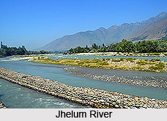
 Jhelum River is a river that flows in India and Pakistan. It is the largest and most western of the five rivers of Punjab. It is a tributary of the Indus River and has a total length of about 725 km (450 mi). In its course this river takes the form of a stream, which is a lovely site for camping in the trekking.
Course of Jhelum River
Jhelum River originates from a spring at Verinag, which is at the foot of Pir Panjal in the south-eastern part of Kashmir Valley. It then flows through Srinagar and Wular Lake and enters Pakistan through a deep ravine. The largest tributary of the Jhelum is the Kishenganga (Neelum) River, which joins near Muzaffarabad and enters into the Punjab.
Etymology of Jhelum River
The Sanskrit name of Jhelum River is "Vitasta". The river got this name from the incident regarding the origin of the river as explained in "Nilamata Purana". Goddess Parvati was requested by Sage Kasyapa to come to Kashmir for purification of the land from evil practices and impurities of Pisachas living there. Goddess Parvati then assumed the form of a river in the Nether World. Then Lord Shiva made a stroke with his spear near the abode of Nila (Verinag Spring). By that stroke of the spear, Goddess Parvati came out of the Nether World. Shiva himself named her as "Vitasta". He had excavated with the spear a ditch measuring one Vitasta (a particular measure of length defined either as a long span between the extended thumb and little finger, or as the distance between the wrist and the tip of the fingers, and said to be about 9 inches), through which the river - gone to the Nether World - had come out, so she was given the name Vitasta by him.
 History of Jhelum River
In ancient times the Indians called Jhelum as "Vitasta" and the Greeks called it "Hydaspes". The Greeks regarded this river a god as they did to most mountains and streams. According to the major religious work Srimad Bhagavad Gita, the Vitasta is one of the many transcendental rivers flowing through land of Bharata, or ancient India.
Alexander the Great and his army crossed the Jhelum in 326 BC at the Battle of the Hydaspes River where it is believed that he defeated the Indian king, Porus.
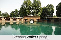
Verinag - Origin of Jhelum River
Verinag is approximately 80 km (50 mi) from Srinagar, by road, at an elevation of 1,876 meters (6,155 ft). It is believed that the eponymous Verinag spring is the chief source of the river Jhelum. There is an octagonal base at the spring, surrounded by a covered passage.
The Verinag spring is one of the principle tourist attractions of Verinag. The spring, which was originally shaped in a circular form was given a change of shape during the reign of the Mughal Emperor Jahangir in 1620, when he gave orders to renovate the spring in the Mughal traditional shape of an octagon. Today, picturesque in its settings and surrounded by tall pine trees, the Verinag Spring is characterized by waters which are calm and sparklingly clear.
Development Projects of Jhelum River
Water control structures are being built across the river, as a result of the Indus Basin Project including several dams, barrages, bridges. Canals are also constructed along the riverside.


