Introduction
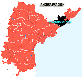 Visakhapatnam district is located towards north-eastern coastal Andhra Pradesh. It is also known by the name of Visakha Zila. The administrative headquarter of the district is Visakhapatnam. Presently the district is one of the busiest commercial and industrial regions of the country.
History of Visakhapatnam District
 History of Visakhapatnam district goes back to an era of long dynastic rule. There is a story behind the name of the district. Tradition has it that some centuries ago a King of Andhra Dynasty encamped on the site of the present Head Quarters Town of Visakhapatnam on his pilgrimage to Varanasi and being pleased with the place, had built a shrine in honour of his family deity called Visakeswara to the South of the Lawsons Bay from which the district has derived its name as Visakheswarapuram which subsequently changed to Visakhapatnam. The encroachment of waves and currents of the sea supposed to have swept away the shrine into off shore area.
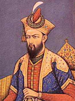
Inscriptions found here indicate that the district was originally a part of Kalinga Kingdom. It later went on to be conquered by the rulers of the Eastern Chalukya dynasty sometime in the 7th century AD. They established their stronghold here and ruled over it with their headquarters at Vengi. Following the Chalukyas, the region came under the rule of a number of rulers belonging to different dynasties. These include the Reddy Rajahs of Kondaveedu, the Gajapathis of Orissa, the Nawabs of Golconda and the Mughal Emperor Aurangzeb through a Subedar.
Due to the constant succession dispute among the Andhra Kings, the territory passed on to the French, and the region finally came under the British reign. There were no geographical graftings till 1936. It was in the same year when, consequent to the formation of the Orissa state, the Taluks namely Bissiom, Cuttack, Jayapore, Koraput, Malkanagiri, Naurangapur, Pottangi and Ryagada in their entirety and parts of Gunpur, Paduva and Parvathipur Taluks were transferred to Orissa State. The Visakhapatnam District was reconstituted with the remaining area and residuary portions of Ganjam District namely Sompeta, Tekkali and Srikakulam Taluks in entirety and portion of Parlakimidi, Ichchapuram, Berahmpur retained in Madras presidency. With the passage of time, the reconstituted District was found administratively unwieldy and therefore it was bifurcated into Srikakulam and Visakhapatnam districts in the year 1950. The residuary district of Visakhapatnam was further bifurcated and the Taluks of Vizianagaram, Gajapathinagaram, Srungavarapukota and a portion of Bheemunipatnam Taluk were transferred to the newly created Vizianagaram District in the year 1979.
Geography Of Visakhapatnam District
 Visakhapatnam District is one of the North Eastern Coastal districts of Andhra Pradesh and it lies between 17°15 minutes and 18°32 minutes Northern latitude and 18° 54 minutes and 83° 30 minutes East longitude. It is bounded on the North partly by the Orissa and partly by Vizianagaram District, on the South by East Godavari District, on the West by Orissa State and on the East by Bay of Bengal. Visakhapatnam District presents two distinct Geographic divisions. The plains division consists of the strip of the land along the coast and the interior and hilly area of the Eastern Ghats flanking it on the North and West called the Agency Division. The Agency Division consists of hills with an altitude of about 900 metres dotted by several peaks exceeding 1200 metres. Sankaram Forest block, topping with 1615 metres, embraces the Mandals of Paderu, G. Madugula, Pedabayalu, Munchingput, Hukumpeta, Dumbriguda, Araku Valley, Ananthagiri, Chinthapalli, G.K. Veedhi, and Koyyuru erstwhile Paderu, Araku Valley and Chinthapalli taluks in entirety. Machkhand River, which on reflow becomes Sileru River, drains and waters the area in its flow and reflow and is tapped for Power Generation. The other division, the plains division, has an average altitude no where exceeding 75 metres watered and drained by Sarada, Varaha and Thandava Rivers and rivulets Meghadrigedda and Gambheeramgedda.
Along the shore lies a series of salt and sandy swamps. The coast line is broken by a number of bald head lands, the important of them being the Dolphin`s Nose which had afforded the establishment of Natural Harbour at Visakhapatnam, Rushikonda(village) Polavaram Rock and the big Narasimha Hill at Bheemunipatnam. Administratively, the District is divided into 3 Revenue Divisions and 43 Mandals.
 The district has differing climatic conditions in different parts. Near Coast the air is moist and relaxing, but gets warmer towards the interior and cools down in the hilly areas on account of elevation and vegetation. April to June are the warmest months. The temperature gets down with the onset of South West Monsoon and tumbles to a mean minimum of 18.8 degree Celsius by December after which there is a reverse trend till the temperature reaches mean maximum of 37.4 degree Celsius by the end of May.
The district receives annual rainfall of 1202 mm, which are contributed to by the South West and North East monsoon. The rest is shared by summer showers and winter rains. Agency and inland Mandals receive more rainfall from the South-West Monsoon, while Coastal Mandals get similarly larger rainfall from North-East monsoon. However, both monsoons play truant, and as there is no accountability of the monsoons, the district experiences drought conditions too often.
More than the one third of the area in the District is covered by forest. The forests are of moist and dry deciduous type. The common species available in them are Guggilam, Tangedu, Sirimanu, Kamba, Yagisa, Nallamaddi, Gandra, Vepa etc. Bamboo shurbs are sparsely scattered. There has been seen a decline in the forest area of the district due to the podu practice. To stem this, regeneration programmes are being carried out.
 As regards the soil in the district, red loamy soils predominate, and cover about 69.9% of the villages of the district. The Soils are poor textured and easily drained. The next most commonly found soil is of the sandy loam variety. It is largely confined to the coastal areas. Black cotton soils are found in sizeable chunks in K.Kotapadu, Devarapalli, Cheedikada, Paderu and Hukumpeta Mandals. The soils in the district are quite low in organic and phosphorous content.
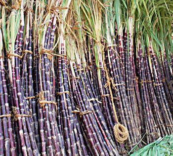
The total geographical area of the district is 11.34 lakh hectares. Of this 30.5% alone is arable area while 42.1 percent is forest area. The rest is distributed among barren and uncultivable land put to non agricultural uses. Agriculture is the mainstay of nearly 70% of the population. Rice is a staple food of the people and paddy is therefore the principal food crop of the district followed by Ragi, Bajra and Jowar, and Cash Crops such as Sugarcane, Groundnut, Sesame and Chillies are important. Since there is no Major Irrigation system, only about 30 percent of the cropped area is irrigated under the Ayacut of the Medium Irrigation System and Minor Irrigation Tanks. The rest of the cultivated area is covered under dry crops depending upon the vagaries of the monsoon. The productivity of the crops is low.
The District has mineral deposits of Bauxite Apatite (Rock Phosphate) Calcite, Crystalline limestone confined to tribal tracts. Bauxite deposits at Sapparla, Jerrila and Gudem of G.K.Veedhi Mandal are considered to be the largest in the country. Phosphate Apatite is available in Kasipatnam village of Ananthagiri Mandal. Rich deposits of crystalline limestone and Calcite are mapped in Borra Caves and along the Valley up to Araku from Borra and around Valasi village of Ananthagiri mandal. Ruby Mica is another mineral available in the District essential for electrical and electronic industries. The mineral occurs in the form of Phologopite and is confined to Borra tract. Quartz is another mineral found mostly in Bheemunipatnam, Padmanabham, Devarapalli, K.Kotapadu and Ananthagiri mandals. Vermiculate found near Kasipatnam of Ananthagiri mandal. Clay deposits near Malivalasa of Araku mandal are identified. Limeshell useful for manufacture of chemical grade lime is also available in the district. Red and Yellow ochre deposits are also identified in Araku and Ananthagiri mandals.
Demography of Visakhapatnam District
 According to the census of 2001, the district has a population of 38.32 lakh and the density of population in the district is 343 persons per square kilometer. The density of the population is more in the plain divisions than in the Agency Division. The sex ratio of the region is 985 females per thousand males and most of the people in the Visakhapatnam district dwell in the villages. The literacy rate in the region is 52.25 percent of which more number of males are literate than the number of females.
Visakhapatnam district has a work force equal to 16.03 lakh as per the census of 2001.
According to the census of 2001, the district has a population of 38.32 lakh and the density of population in the district is 343 persons per square kilometer. The density of the population is more in the plain divisions than in the Agency Division. The sex ratio of the region is 985 females per thousand males and most of the people in the Visakhapatnam district dwell in the villages. The literacy rate in the region is 52.25 percent of which more number of males are literate than the number of females.
Visakhapatnam district has a work force equal to 16.03 lakh as per the census of 2001.
As far as education of the district is concerned it has a number of primary and secondary schools to which large number of students are enrolled. Besides the schools, there are also a number of professional colleges and general colleges which benefit huge number of students annually.
Economy of Visakhapatnam District
The principal occupation of the people of Visakhapatnam is agriculture; almost 70 percent of the households in the region are engaged in agriculture. Rice is the most common crop grown by the farmers of Visakhapatnam. The other cash crops which are grown in the region are sugarcane, groundnut, Chillies and sessamum.
The other allied economic activities of the region are animal husbandry and fishing.
Besides these economic activities in the recent past there has been a lot of industrial development in the region. Some of the major industries of the region are Hindustan Shipyard, Hindustan Petroleum Corporation, Visakhapatnam Steel Plant and a lot more.
Some of the agro based industries of the region are sugar factories, rice mills, jute mills etc. The recent economic development of the region has been aided by the well developed communication system of the district.
Temples of Visakhapatnam District
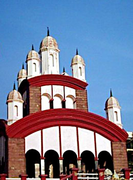
 Visakhapatnam, known as `Vizag`, is a port city, the 2nd largest district in Andhra Pradesh, and the mastermind behind India`s steel production silver lining. It is lovingly called `The City of Destiny`. However, the ancient period of time cannot be neglected, as Visakhapatnam was ruled by perhaps all the key ruling dynasties of the erstwhile era. Hindu temples, evidently occupy a major portion of the district. Some widely explored are- Appikonda Temple, Bheemeswaralayam, Kotilingam Temple, Sri Varaha Lakshminarasimha Temple, Simhachalam Temple, the shrines of Lord Venkateshwara in Kailashgiri, the Bhavatarini Kali Temple and the numerous excavated ruins of Hindu temples, the Buddhist and Jain shrines, yet to be declared accepted by the archaeologists. Ancient caves, standing strong since the pre-historic era, tower the area. The temples, built during the reigns of King Krishna Deva Raya, Emperor Ashoka, the Chola dynasty or the Pallava dynasty, are exclusive in their own style of architecture. Lord Shiva and Vishnu dominate the shrines here too, with a handful of temples consecrated in their name. There is a dearth of the female community, when divinity is concerned. Most of the temples were built in between the 12th-15th centuries.
Kotilingam Temple
Location: Panchadarla near Anakapallee
Deity: Lord Shiva
This temple is situated close to the `five fountains` - five jets of water fed by a perennial spring. The presiding deity Shiva has 12 rows of 85 lingams carved on a single lingam. This temple has inscriptions dating back to the 15th century Eastern Chalukyas.
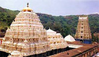
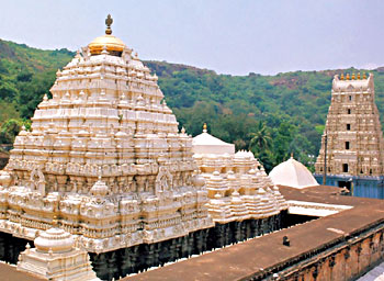
Simhachalam Varaha Lakshminarasimha Temple
The Tamil Cholas and Vijayanagar emperors patronized this temple. Built on a hill, this temple has exquisitely carved halls. There is extensive use of both Chalukyan and Orissa architecture styles. The shrine is dedicated to Lord Narasimha.
Tourism In Visakhapatnam District
Pilgrimage Tourism In Visakhapatnam District :
 Pilgrimage tourism in Visakhapatnam district is an enriching experience as there are a number of temples and places of worship situated here. The prime places of pilgrimage tourism are discussed below.
Simhachalam is a place of pilgrimage in Visakhapatnam mandal. The word Simhachalam means the hill of lion, and it is located 244 metres above sea level. At the Simhachalan temple, one of the richest and best sculptured shrines, is found a man-lion incarnation of Lord Vishnu. Located on the hill is the Simhachalam Varaha Lakshminarasimha temple at a height of 244 metres above sea-level. Architecture of this ancient temple is rather remarkable. It contains a square shrine surmounted by a high tower, a portico in front with a small tower, a square sixteen pillared mandapam facing the portico and an enclosed veranda, all made of dark granite. All these are richly and delicately carved with conventional and floral ornaments and scenes from the Vaishnavite puranas. One of the pillars locally known as the Kappa stambam is believed to possess great curative powers. There is a stone car with stone wheels and prancing stone horses. The image of the deity is small and always kept covered with sandal paste. On the north side of the temple there is an excellent Natya mandapam where Kalyanotsavam is performed. This mandapam is supported by 96 pillars of black stone, exquisitely carved and arranged in sixteen rows of six each.
Apart from the religious importance attached to the place, Simhachalam is a place of enchanting scenic beauty. It is situated on the Simhachalam range of hills about 16 km. from Visakhapatnam connected by both rail and road.
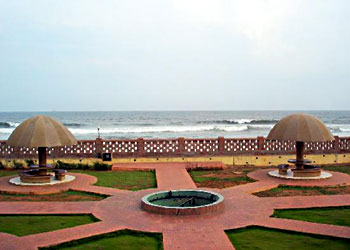
 The Ramakrishna Mission Ashram beach is a beautiful spot for relaxation and pleasure. There is an imposing Kali Temple near this beach. The aquarium here is an added attraction.
The famous Ross Hill on the seashore is a place enveloping three religions viz., Dargakonda has a mosque and a shrine of a Muslim sage Lashaque Madina and Sri Venkateswara Konda has a temple which was built by Capt. Blackmoor in 1886 and the third shrine is a holy place for Christians.
Bhavatarani Charitable Trust was constructed the famous Kali Temple in 1984 on the Beach road. The Temple architecture is very unique. The uniqueness of Shiva Temple is its Linga made of 10 Kg single stone called Rasalinga.
Lothugedda is situated at about 42 Kilometresfrom Narsipatnam of Chintapalli Mandal. The village contains the ruins of 3 or 4 granite temples of Lord Shiva the largest of which has elaborate sculptural depictions.
Appikonda is a small village situated on the coast of the Bay of Bengal at a distance of 18 Kilometresfrom Visakhapatnam. Kapilamahamuni is said to have installed the image of Somalingeswara swamy in this village. It assumed religious importance owing to the existence of a Shiva temple containing a life size bull carved out of black stone. There are also other small temples around the Shiva temple but they are covered with sand dunes and their gopurams alone are visible. The Shiva temple contains inscriptions of the 12th century AD. These inscriptions mention that this village was granted by a Commander in chief of the Cholas for the maintenance of worship in the temple. The Shivaratri festival celebrated here is attended by a large number of devotees.
 The Upmaka village is located at a distance of one kilometre from Nakkapalli. On the hill near Upmaka there is a well known shrine of Lord Venkateswara is one of the important worship places for the devotees.
About 3 kilometres South West of Narsipatnam lies on the Bank of Varaha River a place known as Baligattam. This place owes its importance to the Brahma Lingeswara Temple at the foot of a small hill on the Western bank of the river. Here the shrine faces
the West. It is interesting to note that this temple is supposed to have been built by Lord Brahma and that the river is declared to have been made by Lord Vishnu during his incarnation as a boar (Varaha). Therefore, the river is known as Varahanadi. The deposits of white clay on the river bank are supposed to be the ashes of a sacrifice performed hereby Bali, the demon king from whom the village takes its name as Baligattam. The river at this place flows from North to South for a short distance. On account of these peculiarities, the place is considered to be very sacred. The Shivaratri festival celebrated here every year attracts a large number of devotees.
The Panchadarla village is situated at a distance of about 10 kilometres North East of Yelamanchili and 24 Kilometres. From Anakapalli, it derived its name from the five Jets of water coming out of five fountains which receive their supplies from a natural perennial spring. Near by there is lingam on which are carved other lingams in 12 rows of 85 each and which is consequently known as the Kotilingam or Crore of lingams. There are several inscriptions on the pillars of the Mandapam in the temple and two of them dated in AD 1407 and 1428 contain a genealogy of chiefs who claimed Eastern Chalukya ancestry and bore the Eastern Chalukya titles of Sarvalokasraya and Vishnu Vardana.
Padmanatham lies 16 kilometres North West of Bheemunipatnam on the left bank of the Gosthani River. Padmanabham is known in the local history as the place where the Raja of Vizianagaram was slain in AD 1794 in the fight with the British East India Company`s troops and the spot is marked by a small memory erected in his name. The Padmanabheswara Swamy temple of this place is one of the most important temples of the region. The presiding deity Padmanabha swamy is said to be the lord who readily responds to the desires of his devotees. On the top of the hill which overlooks the place, is the shrine of Padmanabha and the Kalyanostavam of the deity celebrated annually.
Leisure Tourism In Visakhapatnam District
 Leisure tourism in Visakhapatnam district has a lot to offer the in terms of parks, museums, historical monuments and places of natural beauty. For instance, Kailasagiri is a picturesque hill over looking the sea. The 350 acres of natural beauty has been developed into a lush green park has a panoramic sea view with a serene atmosphere with water sprinklers, microwave repeater station and beautiful garden locations making it an outstanding tourist spot. On the top of the hill a giant illuminated statue of Sivaparvatulu and Sanku Chakra and Namalu of Lord Venkateswara are established.
Vuda Park covers a vast area has beautiful greenery and a panoramic sea view. Found here are a dancing musical fountain boating facilities and a skating rink, a well-equipped gymnasium and pleasure rides on horses and camels.
Lumbini Park is located on the beautiful beach road. It has a large statue of Lord Buddha in the middle of the park and is gifted with idyllic hills on one side and the blue sea on the other. It is one of the major tourist attractions of the place.
Mudasarlova, as the name itself depicts, is a valley formed by the natural hills. It is situated 10 Km from Visakhapatnam. It has a lake that supplies drinking water to the city. The Municipal Corporation, Visakhapatnam has developed this into a beautiful park with different types of green plants and orchards. It is a beautiful picnic spot attracting a good number of tourists and public.
A conspicuous land marks in Visakhapatnam the Dolphin`s Nose. It is a huge rocky head land 174 meters high and 358 meters above sea level jutting out into the sea resembling the shape of Dolphin. The powerful beacon of the light house set on rock at sea directs ships 65 Km. away.
A number of places of natural beauty are found at Visakhapatnam district, such as Tyda, Ananthagiri, Kondakarla Ava, Matsyakundam etc. The Victory at Sea is a War Memorial built in 1996 by Eastern Naval Command to Commemorate the Indian Navy Victory at Sea in 1971. The beautiful landscape and coloured fountain around the monument is surrounded by the elegant war tanker Ajanta and War Flight.
The Kurapam tomb is a 100 year old Tomb built in memory of Rani of Kurapam. Its architectural style is spectacular with an amalgamation of the sikara and the dome in the same monument. The structure has carvings of the Acanthus leaf, deities and floral motifs.
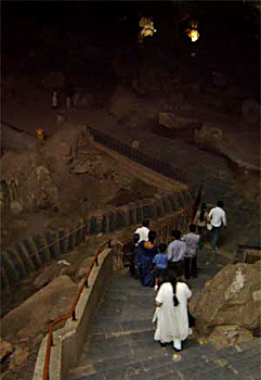
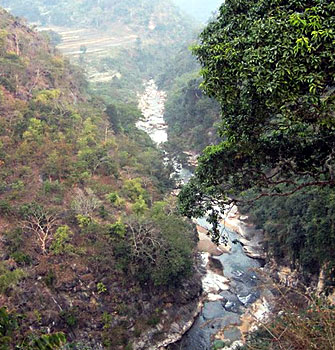
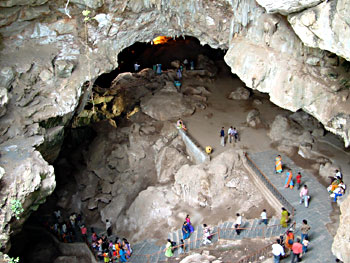
Borra caves are a natural formation in the Eastern Ghats mountain range, situated in Ananthagiri Mandal at a distance of 100 Kilometresfrom Visakhapatnam and 10 Km from Visakhapatnam to Araku Valley road point. The Borra Caves have geological and Historical importance. Deep in the caves there is Sivalingam over which the water drips from above which is said to be the origin of the river Gosthani. The river gosthani flowing from these caves forms a beautiful sight. These caves have been beautifully illuminated and attract a large number of tourists daily. The crystal white calcium stones are seen in various forms like a hooded serpent, Lord Brahma, Radha and Lord Krishna etc.
Gopalapatnam is situated on the left bank of river Thandava in Payakaraopeta Mandal of Visakhapatnam district. Explorations in and around the village revealed many items of historical interest. Found here were stupas, viharas and early historic pottery. These were seen inside the villages as also on the hill ranges. The entire village appears to have been built on ancient habitation.
Sankaram is a small village which is over six Kilometres from Anakapalli. There are two low contiguous rock hills running east and west which are locally known as Bojjannakonda. They contain some notable Buddhist remains. Three huge stupas at three different places were cut with great difficulty from the rocks in these hills. The biggest of these is about nine meters in diameter. On the eastern side of the hills is a rock cut temple with numerous Buddhist Sculptures and also a life size statue of Lord Buddha. Sankaram is a place of great archaeological importance.
 Archaeological excavations have also been made at places like Totlakonda, Bavikonda and Pavurala Konda which have thrown up a number of important findings of historical interest.
Submarine Museum is an originally de-commissioned submarine located on the sands of the R.K.Beach, which has now been converted into a museum. This project is jointly taken up by the NSDRC and Eastern Naval Command.
The Visakha Museum was opened in 1991 to preserve the house collections from the cultural and social heritage of the city of the Visakhapatnam.
A number of beaches are also found scattered around the district, such as Yarada Beach, Gangavaram Beach, Mutyalampalem Beach and Creek, Rushikonda Beach, Bheemili Beach etc. The Etikoppoka village is famous for the toys made here, specially made out of Ankudu wood. The town of Ankapalli is well-known for the - wholesale marketing for Jaggery which is exported to various places in the country. It is also famous for sugarcane and guava fruits.
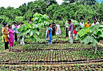
Araku Valley is about 115 Km. from Visakhapatnam lying on the top of the Eastern Ghats. The entire area is inhabited by aboriginal tribes and attracts visitors from all over the country. The Ananthagiri hills on the way to Araku Valley are famous for coffee plantation. Araku Valley has an exploratory-cum demonstration farm which is about 20 hectares in extent a Government orchard and a Government silk farm with mulberry gardens.
The beautiful Araku Valley with its bracing climate, orchards and the Ananthagiri ghats, offers good communication and halting facilities to the tourists. . Dhimsa Dance is a unique feature of the tribes of Araku, which is organised every Saturday and Sunday for entertaining tourists. A habitat museum which reveals the entire
tribal culture and a Horticulture nursery cum training centre at Padmapuram and a waterfall at Ranajilleda is worth seeing at Araku.


